River Thurne

Last updated

Contents

Thurne
Norfolk broads 2.jpg
The River Thurne at Potter Heigham
Norfolk UK relief location map.jpg
Red pog.svg
Location of the river mouth within Norfolk
Location
Country England
Region Norfolk
Physical characteristics
Source 
  locationnear Martham Broad, West Somerton
  coordinates 52°43′19″N1°39′14″E / 52.7219°N 1.6539°E / 52.7219; 1.6539
  elevation1 m (3 ft 3 in)
Mouth River Bure
  location
Thurne
  coordinates
52°40′54″N1°32′57″E / 52.6816°N 1.5492°E / 52.6816; 1.5492 Coordinates: 52°40′54″N1°32′57″E / 52.6816°N 1.5492°E / 52.6816; 1.5492
  elevation
0 m (0 ft)
Length10.6 km (6.6 mi)
Basin features
River system River Bure
River Thurne
BSicon uxSTRwmr.svg
Randall's Mill
BSicon uexSTR.svg
New Cut (drain)
BSicon uexBRUCKEu.svg
Lound Bridge
(limit of navigation)
BSicon uSTR.svg
BSicon uexKHSTa.svg
source of R Thurne
BSicon uSTR.svg
BSicon uSTR+FEATURE@l.svg
West Somerton
BSicon uexSTRq.svg
BSicon uSTRwml.svg
BSicon uSTR.svg
Brograve Drainage Mill
BSicon uSTR+l.svg
BSicon uSTRr.svg
BSicon uSTRwml.svg
West Somerton Drainage Mill
BSicon uSTR.svg
BSicon uDOCKS.svg
New Cut and Martham Broad
BSicon uSTR.svg
BSicon uxSTRwmr.svg
BSicon uSTR.svg
Horsey Drainage Mill (NT)
BSicon uDOCKS.svg
BSicon uexSTRr.svg
BSicon uSTR.svg
Horsey Mere (NT)
BSicon uSTR.svg
BSicon uSTRwml.svg
Highham Holmes Drainage Mill
BSicon uSTR.svg
BSicon uSWING.svg
Martham Ferry floating swing bridge
BSicon uSTRl.svg
BSicon uSTR+r.svg
BSicon uFABZgl+l.svg
BSicon uSTRq.svg
Martham Staithe
BSicon uSTR.svg
BSicon uSTRwmr.svg
Martham Level Drainage Mill
BSicon uDOCKS.svg
BSicon uSTR.svg
BSicon uSTR.svg
Hickling Broad
BSicon uSTRl.svg
BSicon uDOCKS.svg
BSicon uFABZgr+r.svg
Heigham Sound
BSicon uSTRwml.svg
High's Drainage Mill
BSicon uSTR.svg
BSicon uSKRZ-Au.svg
A149 Potter Heigham Bypass
BSicon uSKRZ-Yu.svg
Potter Heigham medieval bridge
BSicon uddSTRl.svg
boat yards
BSicon uSTRwmr.svg
Repp's Drainage Mill
BSicon uSTRq.svg
BSicon uSTRq.svg
BSicon uFABZgr+r.svg
Womack Water
BSicon uSTRwmr.svg
Thurne Dyke Drainage Mill
BSicon uFABZgl+l.svg
BSicon uSTRq.svg
Thurne Dyke
BSicon uSTRwml.svg
St Benet's Level Drainage Mill
BSicon uSTRq.svg
BSicon uSTRq.svg
BSicon uFABZqlr.svg
BSicon uSTR+r.svg
Thurne Mouth
BSicon uSTR.svg
River Bure to Great Yarmouth

The River Thurne is a river in Norfolk, England in The Broads. [1] Just 7 miles (11 km) long, it rises 2 miles (3.2 km) from the coast near Martham Broad and is navigable from West Somerton. It flows southwest and is linked by Candle Dyke and Heigham Sound to both Horsey Mere and Hickling Broad. It continues southwest and flows through Potter Heigham (passing under its medieval bridge) and enters the River Bure just south of Thurne dyke, near St Benet's Abbey.

Sailing on the Thurne through Potter Heigham Sailing on the Thurne through Potter Heigham (20618071264).jpg
Sailing on the Thurne through Potter Heigham

Much of the River Thurne system is navigable, but there are a number of restrictions to the size of boats that can use it. The most famous is the medieval bridge at Potter Heigham. Most road traffic now uses the A149 Bypass, slightly to the north, but the narrow central arch restricts passage to boats needing headroom of less than 6.6 feet (2.0 m), and is the lowest bridge on the Broads. In addition, the river is still tidal here, and although the rise and fall is only about 6 inches (15 cm), currents through the bridge are quite strong. It is a requirement that all hire craft take on a pilot before they pass under the bridge. [2]

Above Potter Heigham, the river is joined by Candle Dyke, which connects to Heigham Sound, from which White Slea Mere leads on to Hickling Broad, where there are moorings. Both Heigham Sound and Hickling Broad are quite shallow, and the navigation channels are clearly marked. Hickling Broad is also a National Nature Reserve. From Heigham Sound, Meadow Dyke leads northwards to Horsey Mere, most of which is a National Trust nature reserve. The National Trust also own Horsey Drainage Mill. Beyond Horsey Mere lies Waxham New Cut, along which boats up to 30 feet (9.1 m) long can travel for about 1.5 miles (2.4 km) to Lound Bridge. The sea is less than 1 mile (1.6 km) from the bridge at this point, although it is 26 miles (42 km) away by boat. [2]

The main river is navigable almost to its source. The channel passes between the parts of Martham Broad, which is a nature reserve owned by the Norfolk Wildlife Trust, to reach West Somerton staithes. The staithes are at the end of a dyke cut from Martham Broad to the village. [2]

Below Potter Heigham, Womack Water is navigable to Ludham, about 1 mile (1.6 km) from the main channel, but is only 4 feet (1.2 m) deep. Navigation is restricted to boats under 46 feet (14 m) in length. Thurne Dyke, a little further below that, is only 3 feet (0.9 m) deep and can be navigated for 170 yards (160 m) to the village of Thurne. [2]

Structures

Potter Heigham bridge is one of the most well-known structures on the Broads. It consists of three arches, two triangular ones built in the fourteenth century, and a central circular arch built when the bridge was altered in the fifteenth century. The brick parapets date from the late eighteenth century. The bridge is a grade II listed structure, and is also a scheduled ancient monument. [3] Just to the north of it is the A149 Potter Heigham Bypass bridge, which now carries most of the traffic which formerly used the medieval bridge, and provides a navigable headroom of 7 feet 7 inches (2.31 m). [4]

The only other place at which vehicles can cross the navigable channel is at Martham Ferry, where a nineteenth-century bridge was replaced in the 1920s by a floating swing bridge, the structure was grade II listed in 1987 but replaced in the same year and was de-listed in 2011. [5] The deck rests on two semi-circular steel buoyancy tanks, and there are concrete abutments on both sides of the river. The bridge pivots on a post at the south side of the river, and is connected by a chain to a winch on the north bank. The structure provides access for farm vehicles from Ferrygate Lane to Heigham Holmes, a national nature reserve managed by the National Trust, which is surrounded by water on all sides, and is normally only open to visitors on one day each year. [6] The deck is lowered onto the concrete abutments when in position by pumping water into the buoyancy tanks, and pumping it out again before the bridge can be opened for navigation. As of 2011 the National Trust were looking to replace the bridge, due to the slow and cumbersome nature of its operation. An engineering survey suggested that a conventional swing bridge or bascule bridge could not easily be installed at the site, and so a replacement of a similar design, but incorporating powered operation is the preferred option. [7] [ needs update ]

The function of the derelict Brograve drainage mill is now performed by an electric pumping station nearby. The derelict Brograve drainage mill - geograph.org.uk - 1103030.jpg
The function of the derelict Brograve drainage mill is now performed by an electric pumping station nearby.

There are nine drainage mills situated along the banks of the river. Brograve Mill on the Waxham New Cut is an early nineteenth century, three-storey brick mill, which is derelict but retained parts of its sails and most of its internal machinery in 2003. [8] West Somerton Mill was built in 1900 by Dan England, from the millwrights England's of Ludham, and is in better condition. Although it has no sails, its internal turbine pump and some of the other machinery are still extant. [9] Horsey Mill is a four-storey structure which pumped water into Horsey Mere, and is owned by the National Trust. It was built in the mid-nineteenth century, and was modified in 1897 and again in 1912, when the work was carried out by Dan England. It originally powered a scoop wheel to raise the water into the mere, but this was replaced by a pumping engine in an outbuilding at the foot of the tower. It ceased to operate in 1943 after being struck by lightning, and was acquired by the National Trust five years later. It was restored in 1961, the work being carried out by the Norfolk Windmills Trust. Its fantail was destroyed during a gale in 1987, and during further restoration, which was completed in 2004, new sails were fitted, but with no shutters or the spider mechanism which operates them. [10] [11] Heigham Holmes Mill is a mid-nineteenth century four-storey brick tower which retains most of its machinery. It is grade II* listed. [12] Like West Somerton, Martham Mill was also built by Dan England, but consists of four storeys and was completed in 1908. It drove a turbine pump, and has now been converted into a residence, [13] as has High's Mill, another four-storey brick tower mill built in the mid-nineteenth century. [14] The next mill downstream is the derelict Repp's Drainage Mill below Potter Heigham.

Thurne Dyke windpump was built in 1820 as a two-storey mill, but a third storey was added in the middle of the nineteenth century. Its cap was blown off during a gale in 1919, and a steam turbine was installed in 1926. It ceased to operate in 1936, and gradually became derelict until it was bought by Bob Morse in 1949, after he moved to Norfolk. He started to restore it with help from Albert England, a descendant of the original builders. Further work was done by the millwrights Thomas Smithdale and Sons of Acle in 1962, and Morse was assisted by the Norfolk Mills Trust from 1975, who funded the fitting of some of the shutters to the sails in 2002, enabling the mill to turn under wind power again. It still contains its internal machinery, which drove an external turbine, housed in an iron casing, and it is grade II* listed. Morse went on to form Morse's Wind Engine Park, a museum devoted to wind pumps from around the world, before he died in 2007. [15] [16] [17] The final mill on the river is at St Benet's Level. It is again grade II* listed, and is a four-storey mill built in the late eighteenth century. It was restored in 1976, when the bevel gears had to be replaced, but all other machinery and the external turbine are intact. [18]

Points of interest

Map all coordinates using: OpenStreetMap  
Download coordinates as: KML

Bibliography

Related Research Articles

The Broads Network of rivers and lakes in East Anglia

The Broads is a network of mostly navigable rivers and lakes in the English counties of Norfolk and Suffolk. Although the terms "Norfolk Broads" and "Suffolk Broads" are correctly used to identify specific areas within the two counties respectively, the whole area is frequently referred to as the Norfolk Broads.

Horning Human settlement in England

Horning is an ancient village and parish in the English county of Norfolk. It covers an area of 11 km2 and had a population of 1,033 in the 2001 census. Horning parish lies on the northern bank of the River Bure south of the River Thurne and is located in The Broads National Park. For the purposes of local government, it falls within the district of North Norfolk, although areas alongside the rivers and broads fall into the executive area of the Broads Authority.

Martham Human settlement in England

Martham is a village and civil parish in the English county of Norfolk. It is situated some 15 km (9.3 mi) north-west of the town of Great Yarmouth and 30 km (19 mi) north-east of the city of Norwich.

Potter Heigham Human settlement in England

Potter Heigham is a village and civil parish on the River Thurne in the English county of Norfolk. It is situated 12 mi (19 km) north-east of the city of Norwich on the A149 road, and within the Broads.

Hickling Broad

Hickling Broad is a 600-hectare (1,500-acre) nature reserve 4 km south-east of Stalham, north-east of Norwich in Norfolk. It is managed by the Norfolk Wildlife Trust. It is a National Nature Reserve and part of the Upper Thurne Broads and Marshes Site of Special Scientific Interest and Hickling Broad and Horsey Mere Nature Conservation Review site, Grade I. It is in the Norfolk Coast Area of Outstanding Natural Beauty, and part of the Broadland Ramsar site and Special Protection Area, and The Broads Special Area of Conservation.

National nature reserves in Norfolk, England are established by Natural England and managed by it or by non-governmental organisations such as the Norfolk Wildlife Trust, the Royal Society for the Protection of Birds, and the National Trust.

Martham Broad

Martham Broad is a 60-hectare (150-acre) national nature reserve north of Great Yarmouth in Norfolk. It is managed by the Norfolk Wildlife Trust, and is part of the Upper Thurne Broads and Marshes Site of Special Scientific Interest. It is also part of the Broadland Ramsar site and Special Protection Area, and The Broads Special Area of Conservation.

River Ant River in Norfolk, England

The River Ant is a tributary river of the River Bure in the county of Norfolk, England. It is 27 kilometres (17 mi) long, and has an overall drop of 27 metres from source to mouth. It is said that the Ant was formerly known as the River Smale and that this is the origin of the name of the village of Smallburgh.

North Walsham & Dilham Canal waterway in the English county of Norfolk

The North Walsham and Dilham Canal is a waterway in the English county of Norfolk. It was authorised by Parliament in 1812, but work on the construction of a canal which ran parallel to a branch of the River Ant did not start until 1825. It included six locks, which were sized to accommodate wherries, and was officially opened in August 1826. It was 8.7 miles (14.0 km) long and ran from two bone mills at Antingham to a junction with the River Ant at Smallburgh. It carried offal for the bone mills and agricultural products, as it proved cheaper to land coal on the beach at Mundesley and cart it overland than to use the canal.

Ludham Human settlement in England

Ludham is a village and civil parish in the English county of Norfolk, in the Norfolk Broads, at the end of a dyke leading to Womack Water and flowing into the River Thurne. It lies 1.5 miles (2.4 km) to the East of Ludham Bridge, which is on the River Ant. It covers an area of 12.18 km2 (4.70 sq mi) and had a population of 1,301 in 582 households at the 2001 census, the population reducing to 1,278 at the 2011 census. For the purposes of local government, it falls within the district of North Norfolk.

Horsey Windpump

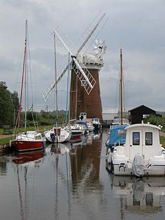
Horsey Windpump is a windpump or drainage windmill in the care of the National Trust in the village of Horsey, on The Broads near Great Yarmouth, Norfolk, England. The structure is a grade II* listed building.

Horsey Mere

Horsey Mere is one of the Norfolk Broads in the east of England; it is one of the more northerly broads close to the North Sea coast.

Brograve Mill grade II listed windmill in the United kingdom

Brograve Mill is a windpump located on Brograve level in the parish of Sea Palling within the Norfolk Broads National Park, United Kingdom. It can be found at grid reference TG448235 and is approximately 1 mile north of Horsey Mere. The mill is a Grade II listed building.

Hickling, Norfolk Human settlement in England

Hickling is a village and a civil parish in the English county of Norfolk. The village is 22 miles south-east of Cromer, 20.3 miles north-east of Norwich and 137 miles north-east of London. The village lies 3 miles east of the Broadlands town of Stalham. The nearest railway station is at Worstead for the Bittern Line which runs between Sheringham, Cromer and Norwich.

Berney Arms Windmill

Berney Arms Windmill is a tower mill located at Berney Arms alongside the River Yare at the south-western end of Breydon Water in the English county of Norfolk. The windmill is in an isolated spot in The Broads around 3.5 miles (5.6 km) north-east of the village of Reedham and 4 miles (6.4 km) south-west of Great Yarmouth. The mill has no road access but can be accessed by boat, by foot or from Berney Arms railway station. It is a Scheduled Ancient Monument under the care of English Heritage.

Boardmans Windmill

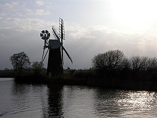
Boardman's Drainage Windmill is located at How Hill in the English county of Norfolk It is on the east bank of the River Ant close to the large Edwardian building houses the Norfolk Broads Study Centre. The Drainage mill is 1+12 miles (2.4 km) west of the village of Ludham. The structure is a grade II* listed building.

Sleaford Navigation Canal in Lincolnshire, England

The Sleaford Navigation was a 12.5 mile (20.1 km) canalisation of the River Slea in Lincolnshire, England, which opened in 1794. It ran from a junction with the River Witham, near Chapel Hill to the town of Sleaford through seven locks, most of which were adjacent to mills. Lack of finance meant that it stopped short of its intended terminus, but it gradually grew to be successful financially. The coming of the railways in 1857 led to a rapid decline, and it was officially abandoned by an act of Parliament in 1878, but remained open for a further three years. The lower part of it remained navigable until the 1940s, when it was blocked by a sluice.

Stubb Drainage Windmill Windmill in Norfolk

Stubb Drainage Windmill is 1.9 miles east of Hickling in the English county of Norfolk. The Windmill is a Grade II listed building and was given this status on 30 September 1987. The estimate is that there were once about 200 wind powered drainage windmills in the Broadlands. Stubb Drainage windmill is listed as one that is at risk of decay by Norfolk County Council.

Heigham Holmes

Heigham Holmes is a national nature reserve located within the Norfolk Broads in the English county of Norfolk. The reserve is, in effect, an island, being surrounded by the river channels, drainage ditches and wetland areas of the Broads. It is only accessible by an unusual floating swing bridge across the River Thurne from the village of Martham.

Upper Thurne Broads and Marshes

Upper Thurne Broads and Marshes is a 1,185.9-hectare (2,930-acre) biological Site of Special Scientific Interest north of Great Yarmouth in Norfolk. Part of it is a Nature Conservation Review site, Grade I, and it is in the Norfolk Coast Area of Outstanding Natural Beauty. It is part of the Broadland Ramsar site and Special Protection Area, and The Broads Special Area of Conservation. Two areas, Hickling Broad and Martham Broad, are national nature reserves managed by the Norfolk Wildlife Trust.

References

  1. Ordnance Survey (2005). OS Explorer Map OL40 - The Broads. ISBN   0-319-23769-9.
  2. 1 2 3 4 Cumberlidge 2009 , pp. 226–227
  3. Historic England. "Potter Heigham Bridge (1305009)". National Heritage List for England . Retrieved 29 August 2011.
  4. "Bridge Heights". Broads Authority. Archived from the original on 2011-09-28. Retrieved 2011-08-29.
  5. "Martham Ferry swing bridge". Norfolk Heritage Explorer. Retrieved 6 August 2019.
  6. "Heigham Holmes open day". Broads Authority. Archived from the original on 2011-09-28. Retrieved 2011-08-29.
  7. "Heigham Holmes Swing Bridge". Eadon Consulting. Archived from the original on 2011-10-07. Retrieved 2011-08-29.
  8. Historic England. "Brograve Mill (1049362)". National Heritage List for England . Retrieved 29 August 2011.
  9. Historic England. "West Somerton Mill (1228023)". National Heritage List for England . Retrieved 29 August 2011.
  10. Historic England. "Horsey Drainage Mill (1373716)". National Heritage List for England . Retrieved 29 August 2011.
  11. "Horsey drainage mill". Norfolk Mills. Retrieved 2011-08-29.
  12. Historic England. "Heigham Holmes Mill (1172656)". National Heritage List for England . Retrieved 29 August 2011.
  13. Historic England. "Martham Mill (1372909)". National Heritage List for England . Retrieved 29 August 2011.
  14. Historic England. "High's Mill (1049921)". National Heritage List for England . Retrieved 29 August 2011.
  15. Historic England. "Thurne Dyke Mill (1050999)". National Heritage List for England . Retrieved 29 August 2011.
  16. "Bob Morse (1924-2007)". Windmill World. Retrieved 2011-08-29.
  17. "Thurne Dyke Drainage Mill". Norfolk Mills. Retrieved 2011-08-29.
  18. Historic England. "St Benet's Level Mill (1171700)". National Heritage List for England . Retrieved 29 August 2011.