The Miami are a Native American nation originally speaking one of the Algonquian languages. Among the peoples known as the Great Lakes tribes, it occupied territory that is now identified as Indiana, southwest Michigan, and western Ohio. By 1846, most of the Miami had been removed to Indian Territory. The Miami Tribe of Oklahoma is the only federally recognized tribe of Miami Indians in the United States. The Miami Nation of Indiana is an unrecognized tribe.

The River Cherwell is a major tributary of the River Thames in central England. It rises near Hellidon in Northamptonshire and flows south through Oxfordshire for 40 miles (64 km) to meet the Thames at Oxford. It adds a significant discharge to the Thames—when entering Oxford, the Thames's discharge is 17.6 m³/s, but after leaving and consuming the Cherwell it has increased to 24.8 m³/s. The river gives its name to the Cherwell local government district and Cherwell, an Oxford student newspaper.

Goulburn River, a perennial river of the Hunter River catchment, is located in the Upper Hunter region of New South Wales, Australia.

Mahabaleshwar is a small town and a municipal council in Satara district in the Indian state of Maharashtra. It is a hill station located in the Sahyadri mountain range. With one of the few evergreen forests of India, it served as the summer capital of Bombay province during the British Raj.

Peel River, a watercourse that is part of the Namoi catchment within the Murray–Darling basin, is located in the North West Slopes and Plains district of New South Wales, Australia.

The West Branch Susquehanna River is one of the two principal branches, along with the North Branch, of the Susquehanna River in the northeastern United States. The North Branch, which rises in upstate New York, is generally regarded as the extension of the main branch, with the shorter West Branch being its principal tributary. The West Branch, which is 243 miles (391 km) long, is entirely within the state of Pennsylvania, draining a large mountainous area within the Allegheny Plateau in the western part of the state. Along most of its course it meanders along mountain ridges and through water gaps, forming a large zigzag arc through central Pennsylvania around the north end of the Allegheny Ridge. In colonial times the river provided an important water route to the Ohio River valley. In the 18th century, its lower valley became a significant industrial heartland of Pennsylvania. In the 20th century, the upper reaches of the West Branch turned a yellow/orange color due to sulfurous drainage from nearby and abandoned deep bituminous coal mines.

The Beaulieu River, formerly known as the River Exe, is a small river flowing through the New Forest in the county of Hampshire in southern England. The river is some 12 miles (19 km) long, of which the last 4 miles (6 km) are tidal. Unusually, the entire river, including its bed, is owned by Lord Montagu of Beaulieu.

The River Bandon is a river in County Cork, Ireland. It rises at Nowen Hill, to the north of Drimoleague. The river then flows to Dunmanway, before turning eastward towards the twin villages of Ballineen and Enniskean. It then makes its way through the centre of Bandon town, and on to Innishannon and Kilmacsimon, before draining into Kinsale Harbour on Ireland's south coast.

The Tungabhadra River is a river in India that starts and flows through the state of Karnataka during most of its course, before flowing along the border between Karnataka, Telangana and Andhra Pradesh and ultimately joining the Krishna River near Alampur village in Mehaboobnagar District of Telangana. In the epic Ramayana, the Tungabhadra River was known by the name of Pampa.

Labis is town and a mukim (commune) in Segamat District in northern Johor, Malaysia. A main trunk road that runs north-south Peninsular Malaysia passes through it, as well as the KTM railway line that connects it with the state's capital in the south, Johor Bahru.

The Kabini, also called Kapila, is one of the major tributaries of the river Cauvery in southern India. It originates in the Wayanad District of Kerala state by the confluence of the Panamaram River and the Mananthavady River. It flows eastward to join the Kaveri River at Tirumakudalu Narasipura in Karnataka.
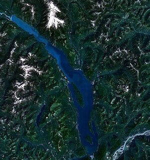
Harrison Lake is the largest lake in the southern Coast Mountains of Canada, being about 250 square kilometres (95 mi²) in area. It is about 60 km (37 mi) in length and at its widest almost 9 km (5.6 mi) across. Its southern end, at the resort community of Harrison Hot Springs, is c. 95 km east of downtown Vancouver. East of the lake are the Lillooet Ranges while to the west are the Douglas Ranges. The lake is the last of a series of large north-south glacial valleys tributary to the Fraser along its north bank east of Vancouver, British Columbia. The others to the west are the Chehalis, Stave, Alouette, Pitt, and Coquitlam Rivers.

Salmo is a village municipality in the West Kootenay region of southeastern British Columbia, Canada. It is located in the Salmo River Valley, surrounded by the Selkirk Mountain range.

The River Lew can refer to either of two short rivers that lie close to each other in Devon, England.
The River Calder is a 13-mile (21 km) long river that is one of the main tributaries of the River Wyre in Lancashire, England. Like the other rivers in England with the name Calder, its name is thought to derive from a mixture of Old Welsh and Old British words meaning "hard and violent water or stream".

The River Meavy is a river in the southwest part of Dartmoor in Devon in south-west England. It runs entirely in the national park and connects Burrator Reservoir to the River Plym.
The River Wolf is a minor river in the west of the county of Devon in England. Its name may come from a Celtic or earlier name recorded by the Roman map-maker Ptolemy as Ουολιβα (Voliba) as a town of the Dumnonii ; rather than referring to the wolf animal.

Llanwrthwl is a village and community in Powys, mid Wales, and the historic county of Brecknockshire. Llanwrthwl lies off the A470 road, north by road from Builth Wells and Newbridge-on-Wye and south of Rhayader. It lies on the River Wye and River Elan and the village is accessed by a bridge over the Wye. In 1833, its population was 517; its population in 1841 was 568; in 1845, its population was 563. In 2005 the community had a population of 201, an electorate of 137 and a council of seven members.

Tin Brook is a 9-mile-long (14 km) tributary of the Wallkill River almost entirely located in the town of Montgomery in Orange County, New York, United States, where it drains 19.2 square miles (50 km2). Near its mouth it flows through the village of Walden. It is one of the few named tributaries of the Wallkill that drain into it from the lowlands between it and the Hudson River to the east, rather than the Shawangunk Ridge to the west.

The River Bray is a small river in North Devon, England. It is a tributary of the River Mole, which in turn is a tributary of the River Taw. It rises in Exmoor, near the border with Somerset.