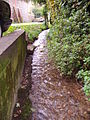
Spring Beck

Last updated
Spring Beck
Spring Beck at Weybourne Spring Beck Weybourne 22nd Oct 2007.JPG
Spring Beck at Weybourne

In Norfolk
Norfolk UK location map.svg
Red pog.svg


Geography
Origin:Hundred Acre Wood, Weybourne Pits
Grid reference: TG 117 419
Mouth:Into the Sea at Weybourne Hope
Grid reference: TG 110 437
Length:2.25 km long (1.4 miles)
Fall:50 metres from source to tidal limit
Catchment Area:Unknown
Tributaries:None
Water Mills:1 Weybourne Watermill

Spring Beck is a minor watercourse flowing near and through the village of Weybourne in the north of the county of Norfolk.

Contents

Course of the beck

This short beck rises from a spring in a substantial hollow on the edge of Hundred Acre Wood in an area called Weybourne Pits, close to Weybourne railway station. From its source it flows under the track bed of the North Norfolk Railway and out across open farmland towards the village of Weybourne about 1-mile (1.6 km) away.
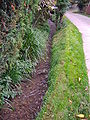
By rights Spring Beck should flow down Beach Road on the northern side of the village, which clearly was the original watercourse, and indeed for a short way an upper overflow channel does just that. The beck's course was modified in the eighteenth century as part of the construction of a watermill and it was dammed to create a substantial mill pond.

The mill and mill pond can be found on Beach Road in Weybourne. Above the mill pond which is now very much silted up and overgrown with rushes, the beck runs round the side of the valley and crosses the A149 coast road near Weybourne Church, at a point some ten to fifteen feet above the lowest point on the road. Streams cannot do this unaided, of course, and indeed it follows an artificial course from some way behind the village, through a site marked: "The Remains of the Priory" and then on to the mill pond.

Water no longer flows through the mill today: the flume is blocked with pre-formed concrete slabs. The spillway is similarly reinforced and conducts the flow round the boundary of the watermill to join the tailrace below. The beck then flows through a culvert under the road to meet the water coming down the road from the upper overflow channel, then out into the marshes behind the shingle bank, often flooding the car park at the end of Beach Road.

Weybourne watermill

The watermill situated on Spring Beck is thought to have been built around 1729, [1] at the same time as the miller's cottage, which has this date built into the wall. The buildings are constructed from beach flint and red brick and have a Norfolk pantiled roof; they are now a private residence. The watermill has not been in operation since the 1930s. [1] The beck’s course was diverted to supply the millpond and power the overshot waterwheel that operated the mill. The beck’s natural course would have been down in the lower part of the gentle valley in which the village of Weybourne is located, probably alongside Beach Road. The diverted course takes a dogleg in the village and can be found to the west of the church and priory remains on higher ground. The millpond is now overgrown and silted up [2] and the millrun has been blocked with concrete. The beck diverts around the old mill building today.

During the 19th century, this area of the coast had a reputation for smuggling. The watermill and much of the Weybourne area were owned by a man called William J. Bolding. It is reputed that he turned a blind eye to smuggled goods landed on the beaches bordering his property and was always duly rewarded with a couple of tubs left discreetly on the mill doorstep.

See also

Related Research Articles

<span class="mw-page-title-main">River Waveney</span> River in east England

The River Waveney is a river which forms the boundary between Suffolk and Norfolk, England, for much of its length within The Broads. The earliest attestation of the name is from 1275, Wahenhe, from *wagen + ea, meaning the river by a quagmire.

<span class="mw-page-title-main">The Moss</span> River in England

The Moss is a brook in North East Derbyshire, England.

<span class="mw-page-title-main">Weybourne, Norfolk</span> Village in Norfolk, England

Weybourne is a village on the coast of North Norfolk, England. The village is surrounded by arable fields, woodland and heathland; it straddles the A149 coast road, 3 miles (5 km) west of Sheringham, within the Norfolk Coast AONB. The area is popular for its local countryside and coastline, particularly for walking, wildlife and bird-watching.

<span class="mw-page-title-main">River Poddle</span> River in Dublin, Ireland

The River Poddle is a river in Dublin, Ireland, a pool which gave the city its English language name. Boosted by a channel made by the Abbey of St. Thomas à Becket, taking water from the far larger River Dodder, the Poddle was the main source of drinking water for the city for more than 500 years, from the 1240s. The Poddle, which flows wholly within the traditional County Dublin, is one of around a hundred members of the River Liffey system, and one of over 135 watercourses in the county; it has just one significant natural tributary, the Commons Water from Crumlin.

<span class="mw-page-title-main">Stainton Beck</span> Stream in Cumbria, England

Stainton Beck is a watercourse in Cumbria, England. Its upper reaches are known as St. Sunday's Beck.

<span class="mw-page-title-main">River Glaven</span> River in Norfolk, England

The River Glaven in the eastern English county of Norfolk is 10.5 mi (16.9 km) long and flows through picturesque North Norfolk countryside to the North Sea. Rising from a tiny headwater in Bodham the river starts 2+12 miles before Selbrigg Pond where three small streams combine. The scenic value of the Glaven valley is important to the tourist industry in North Norfolk. The river is one of over 200 chalk rivers in the world and one of 160 in the UK.

<span class="mw-page-title-main">Heacham River</span> River in Norfolk, England

Heacham River is a small river in the King's Lynn and West Norfolk district of the English County of Norfolk. Its source is near the village of Bircham Newton grid reference TF762 339, 25 metres above sea level. The river is 16.4 kilometres (10.2 mi) long from the source to the outfall on Heacham beach, which discharges into The Wash at low tide.

<span class="mw-page-title-main">River Babingley</span> River in northwest Norfolk, England

The River Babingley is a chalk stream and minor river in the northwest of Norfolk in England. It runs 12.2 miles (19.6 km) from its source at Flitcham to the River Great Ouse at Wootton Marshes where it terminates.

<span class="mw-page-title-main">Rainworth Water</span> Tributary of the River Maun near Rainworth, Nottinghamshire, England

Rainworth Water is a watercourse that is a tributary of the River Maun near Rainworth, Nottinghamshire, England. It is characterised by a number of lakes, including that which forms part of the country park at Rufford Abbey. L Lake at Rainworth forms part of the Rainworth Lakes Site of Special Scientific Interest. There are two designated Local Nature Reserves along its length, one of which is also known by the name Rainworth Water. The Rainworth Water LNR is owned and managed by Nottinghamshire County Council.

<span class="mw-page-title-main">River Mun</span> River in north Norfolk, England

The River Mun or Mundesley Beck is a river in the north of the county of Norfolk, England. Its source is in the parish of Northrepps. The river finally runs into the North Sea in the village of Mundesley.

<span class="mw-page-title-main">Beeston Beck (Norfolk)</span> Minor watercourse in the north of the county of Norfolk, England

Beeston Beck is a minor watercourse in the north of the county of Norfolk, England.

<span class="mw-page-title-main">Scarrow Beck</span> River in England

Scarrow Beck is a minor watercourse which rises in the north of the English county of Norfolk. It is a tributary of the River Bure. Its spring is in the North Norfolk village of Aylmerton west of the main street. It eventually merges, after 7.7 miles (12.4 km) with the River Bure at Ingworth just north of the Blickling Hall estate. There are two watermills on the beck, both of which are no longer in working order. A third windmill at Gresham stands on Gur Beck, a small tributary of Scarrow Beck.

<span class="mw-page-title-main">Gur Beck</span> River in Norfolk, England

Gur Beck is a minor watercourse which rises in the north of the English county of Norfolk. It is a tributary of the Scarrow Beck. Its spring is a little east of the North Norfolk village of West Beckham. It eventually merges after 4.2 miles (6.8 km) with the Scarrow Beck at Sustead. There is one watermill on the beck. This can be found in the village of Gresham, but is no longer in working order.

<span class="mw-page-title-main">Hagon Beck</span> River in Norfolk, England

Hagon Beck is a minor watercourse which rises in the north of the English county of Norfolk. It falls into Great Lake in Gunton Park, which in turn feeds Suffield Beck. Suffield Beck is a tributary of Blackwater Beck which in turn joins the River Bure. Its spring is a little north of the North Norfolk village of Roughton. There were two watermills on the beck. The first was located at Gunton, and the second is a sawmill in Suffield Park.

<span class="mw-page-title-main">River Gavenny</span> River in Monmouthshire, Wales

The River Gavenny or sometimes the Gavenny River is a short river in Monmouthshire in south Wales. It rises 1 mile (1.6 km) southwest of the village of Llanvihangel Crucorney from springs near Penyclawdd Court, supplemented by springs in Blaen-Gavenny Wood and tributary streams there and within the Woodland Trust-owned Great Triley Wood. It flows south for about 4 miles (6.4 km) to its confluence with the River Usk towards the eastern end of Castle Meadows at Abergavenny. The town derives its English-language name from the Gavenny's confluence with the River Usk. Of the buildings on the banks of the river, the Gothic Decorated style church of St Teilo at Llantilio Pertholey is especially notable. Parts of the church date from the thirteenth century with multiple additions since. Blaengavenny Farm, the name of which signifies the 'head of the Gavenny', is a sixteenth-century farmhouse near the river's source.

<span class="mw-page-title-main">Land Yeo</span> River in north Somerset, England

The Land Yeo is a small river which flows through North Somerset, England. It rises on Dundry Hill and supplies Barrow Gurney Reservoirs before flowing through various villages to Clevedon where it drains into the Severn Estuary. During the past 1,000 years it has powered at least ten watermills, however only one is still functional. Since 2003 initiatives have been undertaken to clean up the river, improving water quality and encouraging wildlife.

<span class="mw-page-title-main">Bedale Beck</span> Watercourse in North Yorkshire, England

Bedale Beck is a river that flows through the eastern end of Wensleydale and passes through Crakehall, Bedale and Leeming before entering the River Swale at a point between Morton-on-Swale and Gatenby. Between source and mouth its length is 25.7 miles (41 km).

<span class="mw-page-title-main">Watermills on Zala River</span>

For centuries, the watermills on the Zala river had co-existed in a single harmonious unity with each other as well as with the river, the Zala valley and Zala meadow, both latter ones renowned for their beauty. Landscape rehabilitation would indeed be necessary because due to the closure of the mills and the destruction of the sluices, the level of the ground water in the meadows, usually having very loamy soil, has dramatically decreased, which has had detrimental impacts on the condition of the meadows. The declining tendency in the grassland culture has not helped either. What is more, in several cases parts of the meadows were turned into arable lands or industrial sites. The final blow to the deteriorating meadows that gradually grew characterless was dealt by the disgraceful regulation of the river Zala in the beginning of the 1960s. A further station of the process was the elimination of the mills from the life of the river for all. „There were about 200 known steam mills and watermills in the county Zala at the end of the 1800s. According to the statistical data of the Zala county archives of the year 1949, there were about 180 mills in operation in the county then. In the beginning of the 1940s, there were still about 37 mills grinding on the river Zala. One can still find water in some old mill-ponds. These ponds provide suitable habitat for some aquatic organisms. As for the history of the published data and photos, I. Hajdu, J. Izsák, Á. Jakosa, Gy. Kummer and Mrs. M. Marx, the latter working with Göcseji Muzeum, Zalaegerszeg decided in 2004 to start gathering documents and data systematically on the watermills along the river Zala. We have based our selection of the mills to be presented on a list from the year 1949 preserved in the Zala-county archives. The chart was provided by Mr. Gy. Kummer. A significant number of the photos were also taken by him. The mills indicated by red characters exist today mainly in documents and in the mind's eye only. For the possibility of hydropower by the water of small rivers, e.g. Zala, see Gerse 2014.

<span class="mw-page-title-main">Sea Cut (Scalby Beck)</span> River in North Yorkshire, England

The Sea Cut (Scalby Beck) is a small river that enters the North Sea at Scalby Mills, Scarborough, North Yorkshire, England. The beck is fed from local streams in Scalby, Newby and Burniston and other watercourses draining off the nearby hills. It is also a bypass channel for the upper reaches of the River Derwent when it is under flood conditions.

<span class="mw-page-title-main">Bow Brook, Hampshire</span> River in Hampshire, England

Bow Brook is a small river in the English county of Hampshire, which is a tributary of the River Loddon. Contributary streams rise near Ramsdell and Sherborne St John, and after flowing through rural countryside, it joins the Loddon near Sherfield on Loddon. Historically it has powered at least two watermills.

References

52°56′56.0″N1°8′22.2″E / 52.948889°N 1.139500°E / 52.948889; 1.139500