Cantley, South Yorkshire

Last updated

Cantley
St.Wilfrid's church, Cantley - geograph.org.uk - 173900.jpg
St Wilfrid's Church
South Yorkshire UK location map.svg
Red pog.svg
Cantley
Location within South Yorkshire
Population2,817 (2011 census) [1]
Civil parish
  • Cantley
Metropolitan borough
  • Doncaster
Metropolitan county
Region
Country England
Sovereign state United Kingdom
Post town DONCASTER
Postcode district DN3, DN4
Dialling code 01302
Police South Yorkshire
Fire South Yorkshire
Ambulance Yorkshire
UK Parliament
List of places
UK
England
Yorkshire
53°31′N1°04′W / 53.51°N 1.06°W / 53.51; -1.06 Coordinates: 53°31′N1°04′W / 53.51°N 1.06°W / 53.51; -1.06

Cantley is a village and civil parish in the City of Doncaster in South Yorkshire, England. The village is adjacent to Bessacarr, separated by Bawtry Road. It has a population of 2,830, [2] reducing slightly to 2,817 at the 2011 Census. [1]

Contents

Etymology

The second part of the name is the Old English –lēah meaning "a clearing, pasture, meadow". [3] This is suffixed either to Canta-, an unrecorded but plausible Old English hypocorism, [3] or the Brittonic cant meaning "a circumference, a boundary" and "a division, share of land" (Welsh cant). [3]

Early history

Cantley Hall was probably a home from around the 7th or 8th century, owned by a Saxon called Tochi prior to the conquest of England by the Normans in 1066, after which it probably went to the Everingham's or Everingham Ancestors. By 1209 it was known as Kanteleia, and Cauntele in 1246. By 1280 it was in the possession of Robert de Everingham. The Everingham name lives on to this day in Everingham Road, one of the main roads through Cantley. By the late 15th century the name of Cantley had been established and remained, [4] while the residents of the estate were the Smith family. [5]

Today

Whiphill Top Lane Whiphill Top Lane - geograph.org.uk - 1261347.jpg
Whiphill Top Lane

Most of Cantley was built after the Second World War, with many of its houses 1950s built semi-detached or small terraces. It mainly consists of housing estates, some council estates, plus a large park and areas of woodland. There are two main sets of shops - Everingham Road has a local convenience store, post office, bakers, grocers, butchers, hairdressers, DIY, and the popular "Fish Dish" fish & chip shop. St Wilfrid's shops are near the local health centre and have several convenience stores, off licences, hairdresser's and a Chinese takeaway. The Cantley Library is situated at St Wilfrid's. There is also a Co-Op on Goodison Boulevard, and two petrol stations. A secondary school, The McAuley Catholic High School, is situated across two campuses towards Old Cantley, and primary schools include Hatchell Wood (previously South Cantley Middle School), and Hawthorn Primary School

There were three pubs in Cantley, one near the park ("Bechers Brook", named for the Grand National fence), another at Everingham Road shops ("The Palfreys Lodge") and a third ("The Paddock") at Cantley Lane roundabout. ("The Paddock") closed and was converted into a My Local convenience store, eventually closed when My Local collapsed in June 2016. The pub names were all linked to horse racing - The Palfreys Lodge was originally called "The Two Palfrey's".

The street names in Cantley have links to each other in groups. Examples are streets named after trees e.g. Lilac Grove, Pine Road, Willow Avenue. Another linked group are football grounds e.g. Ninian Grove, Anfield Road, Ewood Drive, Hillsborough Road. Race courses are another group of street names e.g., Ascot Avenue, Newmarket Road, York Gardens, and Epsom Road.[ citation needed ]

Cantley has two large landmarks in the form of two water towers. These can be seen from almost any high ground around the Doncaster district.[ citation needed ]

Cantley has good transport links into Doncaster with a regular bus service from First South Yorkshire route 57, which is now extended for certain journeys to take in the old 91 route to Finningley. Previously First routes 57, 59 and 91 served the village, and before that Leon services 89 and 191. Because of the bus connection, it is a popular retirement village for many people.[ citation needed ]

Old Cantley

The village of Old Cantley, around half a mile in the Armthorpe direction, is built around the Grade II listed Georgian manor house Cantley Hall, presently owned by Graham Kirkham, Baron Kirkham of Old Cantley the founder and chairman of sofa retailer Dfs. [6]

See also

Related Research Articles

<span class="mw-page-title-main">Conisbrough</span> Town in South Yorkshire, England

Conisbrough is a town within the City of Doncaster, in South Yorkshire, England. It is roughly midway between Doncaster and Rotherham, and is built alongside the River Don at 53°29′N1°14′W. It has a ward population of 14,333.

<span class="mw-page-title-main">Austerfield</span> Village in South Yorkshire, England

Austerfield is a village and civil parish in the Metropolitan Borough of Doncaster, South Yorkshire, England. It is 1 mile (1.6 km) to the north-east of the market town of Bawtry on the A614 road, and adjacent to the hamlet of Newington in Nottinghamshire, close to the River Idle. The population in 2001 was 571, which fell to 536 at the 2011 Census.

<span class="mw-page-title-main">Dodworth</span> Village in South Yorkshire, England

Dodworth is a village in the metropolitan borough of Barnsley in South Yorkshire, England. Historically part of the West Riding of Yorkshire, it has a population of 5,742, increasing to 5,900 at the 2011 Census.

<span class="mw-page-title-main">Bessacarr</span> Area of Doncaster, South Yorkshire, England

Bessacarr is a suburb on the south-east edge of Doncaster, South Yorkshire, England. Consisting of mostly private residential development from the 1960s onward, it also contains some of the most expensive property in Doncaster, around St Wildfrid's Road and Warning Tongue Lane. It is largely interwoven with Cantley to the north-east having partially signposted ancient boundaries, upon which its population was 19,803 at the 2001 census.

<span class="mw-page-title-main">Dunnington</span> Village and civil parish in North Yorkshire, England

Dunnington is a village and civil parish in the City of York and ceremonial county of North Yorkshire, England. The population of the civil parish was 3,230 at the 2011 Census. The village is approximately 4 miles (6 km) east from York city centre.

<span class="mw-page-title-main">Balby</span> Suburb and civil parish in South Yorkshire, England

Balby is a civil parish and suburb of Doncaster in the City of Doncaster district in South Yorkshire, England. Historically part of the West Riding of Yorkshire, Balby is within the Doncaster Central constituency and contains the electoral wards Balby South and Hexthorpe and Balby North.

<span class="mw-page-title-main">Armthorpe</span> Village in South Yorkshire, England

Armthorpe is a large suburban village and civil parish in the City of Doncaster, South Yorkshire, England. Historically within the West Riding of Yorkshire, it had a population of 12,630, increasing to 14,457 at the 2011 Census.

Sprotbrough and Cusworth is a civil parish in the City of Doncaster in South Yorkshire, England, with most of its settlements on the western edge of the Doncaster built-up area. It lies between 1 mile (1.6 km) and 4 miles (6.4 km) to the west of Doncaster and is split by the A1(M) motorway. It had a population of 12,166 in 2001 and 12,134 at the 2011 Census. The parish covers most of Doncasters outlying suburbs including the villages of Sprotbrough, Cusworth, and a small part of Scawsby, in addition to several rural hamlets and farmsteads.

<span class="mw-page-title-main">Brayton, North Yorkshire</span> Village and civil parish in North Yorkshire, England

Brayton is a village and civil parish in the Selby District of North Yorkshire, England. The village is situated approximately 1 mile (1.6 km) south from Selby. The parish includes some of south-western Selby, as well as the village of Brayton.

<span class="mw-page-title-main">Edlington</span> Town and civil parish in South Yorkshire, England

Edlington is a town and civil parish in the City of Doncaster, South Yorkshire, England, lying to the south west of Doncaster and Warmsworth. It has a population of 8,276. The original parish town of Edlington is now known as Old Edlington; adjacent, and to the north, is New Edlington. It is often referred to by locals as 'Edlo'. Since 1974 Edlington has been part of the Metropolitan Borough of Doncaster in the metropolitan county of South Yorkshire. It had, since 1894, formed part of Doncaster Rural District in the West Riding of Yorkshire.

<span class="mw-page-title-main">Graham Kirkham, Baron Kirkham</span>

Graham Kirkham, Baron Kirkham, is an English businessman, the founder and chairman of sofa retailer DFS.

<span class="mw-page-title-main">Cantley Hall</span>

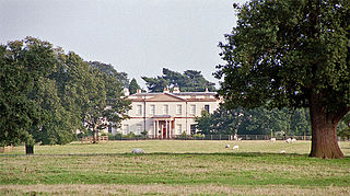
Cantley Hall is a grade II* listed Georgian mansion set in 400 acres (160 ha), in the village of Old Cantley in Doncaster, South Yorkshire, England.

<span class="mw-page-title-main">Crofton, West Yorkshire</span> Village near Wakefield, West Yorkshire, England

Crofton is a village in West Yorkshire, England, about 4 miles (6 km) south-east of Wakefield, some 6 miles (10 km) to the west of the town of Pontefract, and 4 miles (6 km) from the town of Featherstone. The population of the civil parish at the 2011 census was 5,781.

<span class="mw-page-title-main">Cowling, Craven</span> Village and civil parish in North Yorkshire, England

Cowling is a village, electoral division and civil parish in the Craven district of North Yorkshire, England. It is situated on the borders with the adjacent counties of West Yorkshire, and Lancashire.

Harden is a civil parish and village within the City of Bradford Metropolitan District, West Yorkshire, England, 2 miles (3.2 km) west of Bingley. It had a population of 1,615 in the 2001 census, but by 2011 this had risen to 1,900.

<span class="mw-page-title-main">Edenthorpe</span> Village and civil parish in South Yorkshire, England

Edenthorpe is a village and civil parish on the eastern edge of Doncaster, South Yorkshire, England. At the 2001 census, it had a population of 4,752, increasing slightly to 4,776 at the 2011 Census. The village lies 4 miles (6.4 km) to the north east of Doncaster town centre.

<span class="mw-page-title-main">Sprotbrough</span> Village in South Yorkshire, England

Sprotbrough is a village in the City of Doncaster in South Yorkshire, England, 3 miles (4.8 km) west of Doncaster city centre. With Cusworth to the north, it forms the civil parish of Sprotbrough and Cusworth. Sprotbrough village had a population of 3,321 at the 2011 census; this does not include the area of Newton to the east of the A1(M). The civil parish of Sprotbrough and Cusworth had a population of 12,134, which also includes Cusworth, Newton and part of Scawsby.

<span class="mw-page-title-main">Cusworth</span> Suburb of Doncaster, South Yorkshire, England

Cusworth is a village and suburb of Doncaster in South Yorkshire, England, located 2 miles (3.2 km) to its north-west within the civil parish of Sprotbrough and Cusworth and the City of Doncaster, with a population of 4,728. It is home to Cusworth Hall, an 18th century country house, and its surrounding parkland. Some buildings in the old village can be dated back to the 16th century.

<span class="mw-page-title-main">Steeton, West Yorkshire</span> Village in West Yorkshire, England

Steeton is a village in the City of Bradford metropolitan borough, West Yorkshire, England. Historically part of the West Riding of Yorkshire, it is situated approximately 5 miles (8 km) south-east from Skipton, 3 miles (5 km) north-west from Keighley and just south of the A629 road. The village is part of Steeton with Eastburn civil parish.

<span class="mw-page-title-main">Branton, South Yorkshire</span> Village in South Yorkshire, England

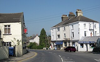
Branton is a village in South Yorkshire, England. It is about 4 miles (6.4 km) east of Doncaster. At the 2011 census, it had a population of 1,992.

References

  1. 1 2 UK Census (2011). "Local Area Report – Cantley Parish (E04000070)". Nomis. Office for National Statistics . Retrieved 9 September 2021.
  2. UK Census (2001). "Local Area Report – Cantley Parish (00CE014)". Nomis. Office for National Statistics . Retrieved 9 September 2021.
  3. 1 2 3 James, Alan. "A Guide to the Place-Name Evidence" (PDF). SPNS - The Brittonic Language in the Old North. Archived from the original (PDF) on 13 August 2017. Retrieved 25 November 2018.
  4. "Cantley Hall". Everingham.com. Retrieved 6 March 2017.
  5. "ANNALS OF SMITH OF CANTLEY, BALBY, AND DONCASTER, COUNTY YORK" (PDF). blunham.com. Archived from the original (PDF) on 17 May 2005. Retrieved 17 January 2022.
  6. "Sofa king sitting pretty on £315m pile". Sheffield Star. Archived from the original on 31 October 2002. Retrieved 6 March 2017.