
Dorney is a village and civil parish in the Unitary Authority of Buckinghamshire, England, bordering on the River Thames to the west and south and bisected by the Jubilee River. In 2011 it had a population of 752 and it is 2.3 miles (3.7 km) west of neighbouring Eton which is a slightly larger parish.

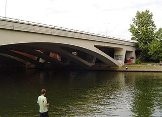
The Jubilee River is a hydraulic channel in southern England. It is 11.6 km (7.2 mi) long and is on average 45 metres wide. It was constructed in the late 1990s and early 2000s to take overflow from the River Thames and so alleviate flooding to areas in and around the towns of Maidenhead, Windsor, and Eton in the counties of Berkshire and Buckinghamshire. It achieves this by taking water from the left bank of the Thames upstream of Boulter's Lock near Maidenhead and returning it via the north bank downstream of Eton. Although successful in its stated aims, residents of villages downstream, such as Wraysbury, claim it has increased flooding.

Maidenhead Railway Bridge is a single structure of two tall wide red brick arches buttressed by two over-land smaller arches carrying the Great Western main line (GWML) over the River Thames between Maidenhead, Berkshire and Taplow, Buckinghamshire, England. It crosses the river on the Maidenhead-Bray Reach which is between Boulter's Lock and Bray Lock and is near-centrally rooted in the downstream end of a very small island.

Bray Lock is a lock and weir on the River Thames in England near Bray and Dorney Reach, and is just above the M4 Bridge across the Thames. The lock is on the Buckinghamshire side of the river on the opposite bank from Bray itself and Maidenhead which are in Berkshire. Here, the county line stands roughly halfway between the lock and the opposite bank, following the course of the Thames itself. The pound lock was built by the Thames Navigation Commission relatively late, in 1845. The lock keeper's cottage is on an island between the lock and the weir.

The A308 is a road in England in two parts. The first part runs from Central London to Putney Bridge. The second part runs from just beyond Putney Heath to Bisham, Berkshire. It traces four, roughly straight lines, to stay no more than 3 miles (4.8 km) from the Thames. It is a dual carriageway where it is furthest from that river, in Spelthorne, Surrey and forms one of the motorway spurs to the large town of Maidenhead. Other key settlements served are Fulham, Kingston (London), Staines upon Thames, Windsor and a minor approach to Marlow

Maidenhead Bridge is a Grade I listed bridge carrying the A4 road over the River Thames between Maidenhead, Berkshire and Taplow, Buckinghamshire, England. It crosses the Thames on the reach above Bray Lock, about half a mile below Boulter's Lock. The Thames Path crosses the river here.

Marlow By-pass Bridge is a road bridge across the River Thames in England. It carries the A404 road between Maidenhead, Berkshire and High Wycombe, Buckinghamshire. and crosses the Thames on the reach between Cookham Lock and Marlow Lock.

The M3 Chertsey Bridge is a motorway bridge in England built in the 1970s.
The M25 Runnymede Bridge is a motorway, A-road and pedestrian and cycle bridge built in the 1960s, 1980s and expanded in the 2000s carrying the M25 and A30 across the River Thames near the uppermost end of the Staines upon Thames and Egham reach of river. It is oriented north–south and is southwest of Heathrow Airport. It consists of the Runnymede Bridge and the New Runnymede Bridge; commonly referred to as one bridge.
Penton Hook Lock is the sixth lowest lock of forty four on the non-tidal reaches of the River Thames in England. It faces an island which was until its construction a pronounced meander and is on the site of its seasonal cutoff. It is against the left bank marking the church parish medieval border of Laleham and Staines upon Thames in Surrey for many centuries. Until 1965 their county was Middlesex. At 266 ft (81 m) it is the third longest lock on the river.

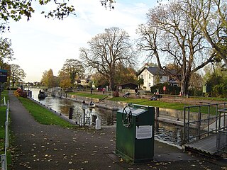
Romney Lock is a lock on the River Thames in England near Windsor and Eton, about half a mile downstream of Windsor Bridge. It is on the Windsor side of the river next to a boatyard and adjoins Romney Island, a long strip-shaped ait in the middle of the river. The first lock was built by the Thames Navigation Commission in 1798.
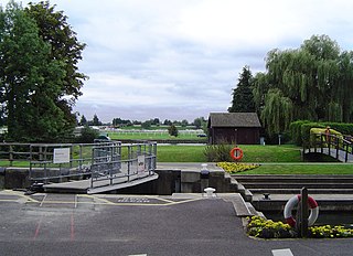
Boveney Lock is a lock on the River Thames situated on the Buckinghamshire bank opposite the Windsor Racecourse and close to Eton Wick. Boveney is a village a little way upstream on the same side. The lock was first built in 1838 by the Thames Navigation Commission. The lock was rebuilt in 1898 closer to the Buckinghamshire bank, and a set of boat rollers were installed on the old site.

Hollyhock Island is an inhabited island in the River Thames in England on the reach between Bell Weir Lock and Penton Hook Lock.

The Summerleaze Footbridge is a footbridge across the River Thames in England linking Dorney, Buckinghamshire and Bray, Berkshire; it is about two miles downstream of Maidenhead Bridge, on the reach above Boveney Lock.

The Maidenhead Waterways are a system of canals in Maidenhead, England. Formerly disused, plans to restore and upgrade them were announced in 2011. The works would initially make the waterways navigable by small craft, and over time by larger craft, as limitations to navigation are gradually removed.

Bridge Eyot also known as Bridge Ait is an island in the River Thames in England just above Maidenhead Bridge on the reach above Bray Lock, near Maidenhead, Berkshire. The island is owned by the Royal Borough of Windsor and Maidenhead.

Grass Eyot is an island in the River Thames in England above Maidenhead Bridge on the reach above Bray Lock, near Maidenhead, Berkshire.
Maidenhead Regatta is a rowing regatta in England which takes place in Maidenhead, Berkshire. It is held in August.
The Colne Brook is a river in England that is a distributary of the River Colne which runs from Uxbridge Moor, there forming the western border of Greater London, to the River Thames just below Bell Weir Lock in Hythe End, Wraysbury, Berkshire.


