Bell Weir Lock

Last updated

Bell Weir Lock
BellWeirLock01.JPG
Bell Weir Lock with the M25 crossing beyond
Waterway River Thames
County Surrey
Maintained by Environment Agency
OperationHydraulic
First built1817
Latest built1877
Length78.51 m (257 ft 7 in) [1]
Width7.44 m (24 ft 5 in) [1]
Fall1.82 m (6 ft 0 in) [1]
Above sea level47'
Distance to
Teddington Lock
17 miles
Power is available out of hours
Bell Weir Lock
BSicon uCONTg.svg
River Thames
BSicon uWEIRr.svg
BSicon uSTRq.svg
BSicon uSTR+r.svg
BSicon uSKRZ-Eu.svg
BSicon uSTR.svg
Ham Lane bridge
BSicon ueABZgl.svg
BSicon uexSTR+r.svg
BSicon uSTR.svg
BSicon uFGATEu.svg
BSicon uxWEIRg.svg
BSicon uSTR.svg
Old Windsor Lock
BSicon uFABZgl+l.svg
BSicon ueABZqr.svg
BSicon uSTRr.svg
BSicon uFABZgl+l.svg
BSicon uSTR+r.svg
BSicon uSTR.svg
BSicon uddSTRr.svg
moorings
BSicon uSTR.svg
BSicon uexSKRZ-Eu.svg
Friary Island
BSicon uSTR.svg
BSicon uexSTR.svg
BSicon uFABZgl+l.svg
BSicon uexSTRr.svg
BSicon uISLAND.svg
Pats Croft Eyot
BSicon uFABZgl+l.svg
BSicon uSTR+r.svg
BSicon uSTR.svg
BSicon uSKRZ-Eu.svg
Magna Carta Island
BSicon uFABZgl+l.svg
BSicon uSTRr.svg
BSicon ueABZgl.svg
BSicon uexSTR+r.svg
BSicon uSTR.svg
BSicon uexSKRZ-Eu.svg
The Island
BSicon ueABZg+l.svg
BSicon uexSTRr.svg
BSicon uWEIRr.svg
BSicon uexCONTfq.svg
weir
BSicon uWEIRr.svg
BSicon uexSTR+r.svg
weir
BSicon uFGATEu.svg
BSicon uSTR.svg
Bell Weir Lock
BSicon uABZg+l.svg
BSicon uSTRr.svg
BSicon uCONTf.svg
River Thames

Bell Weir Lock is a lock on the River Thames in England by the right bank, Runnymede which is a water meadow associated with Egham of importance for the constitutional Magna Carta. It is upstream of the terrace of a hotel and the a bridge designed by Edwin Lutyens who designed an ornamental park gate house along the reach. The bridge has been widened and carries the M25 and A30 road across the river in a single span. The lock was first built by the Thames Navigation Commission in 1817; it has one weir which is upstream. The lock is the eighth lowest of forty-five on the river and is named after the founder of the forerunner of the adjoining hotel who took charge of the lock and weir on its construction.

Contents

Bell Weir Lock with the weir behind BellWeirLock02.JPG
Bell Weir Lock with the weir behind

History

A proposed location for a pound lock (impounded water as opposed to a flash lock) in 1811 was across the next bend upstream. The lock and embankments were built at its present site in the winter of 1817–1818. It was known as Egham Lock, but took its name from Charles "Charlie" Bell who founded in the 18th century an inn by the site, The Anglers Retreat, which he continued to operate when entrusted with keeping the lock and weir. [2] The weir collapsed under weight of ice in 1827, so too the lock in 1866. Lock and weir were rebuilt in 1867. The lock had to be rebuilt in stone in 1877. A new weir was completed in 1904. [3] [4]

Access to the lock

The lock can be reached on foot from the A308 road and is behind the Runnymede Hotel.

Reach above the lock

The meadow and riverside at Runnymede with a Lutyens gatehouse, as seen from the Kennedy Memorial Runnymede from Kennedy Memorial.JPG
The meadow and riverside at Runnymede with a Lutyens gatehouse, as seen from the Kennedy Memorial

The reach runs through Runnymede to Old Windsor. Immediately on the left bank (right heading upstream) is a water input and management facility at the Hythe End part of Wraysbury that supplies the Staines Reservoirs followed by low-rise housing with gardens as on "The Island"; woods facing Magna Carta Island tucked close followed by Pats Croft Eyot; and more riverside dwellings at Wraysbury and on Friary Island. The right bank has riverside houses and a greater recreation area then the Runnymead meadows and Arts and Crafts architecture (Edwin Lutyens) gate houses. The Bells of Ouseley public house commemorates bells of Osney Abbey, Oxford which at the abbey's dissolution disappeared into the mud in official records. A longer built-up stretch follows at Old Windsor.

There are no bridges or ferries.

The reach is home to Wraysbury Skiff and Punting Club. Egham Regatta is held near Hythe End in June; Wraysbury and Old Windsor Regatta is held in August. Pleasure boats from the recreation ground can be launched upstream. The refreshment terraces of a hotel and spa adjoin the lock; hot-tub tugs and others with awnings operate. Its restaurants are The Lock and the Left Bank. [5] [6]

Thames Path

The Thames Path, having changed sides at Staines Bridge runs along the right bank to Old Windsor Lock.

Literature and the media

In Three Men in a Boat, Jerome K Jerome records

Harris and I began to think that Bell Weir lock must have been done away with ... It was half-past seven when we were through .... We had originally intended to go on to Magna Carta Island....But somehow we did not feel that we yearned for the picturesque nearly so much now as we had earlier in the day. A bit of water between a coal barge and a gasworks would have quite satisfied us for that night

See also

Next lock upstream River Thames Next lock downstream
Old Windsor Lock
4.94 km (3.07 mi) [7]
Bell Weir Lock
Grid reference: TQ017720
Penton Hook Lock
4.33 km (2.69 mi) [7]

Related Research Articles

Wraysbury Human settlement in England

Wraysbury is a village and civil parish in the Royal Borough of Windsor and Maidenhead in England. It is under the western approach path of London Heathrow airport. It is located on the east bank of the River Thames, roughly midway between Windsor and Staines-upon-Thames, and 18 miles (29 km) west by south-west of London.

Egham Town in Surrey, England

Egham is a university town in the Borough of Runnymede in Surrey, England, approximately 19 miles (31 km) west of central London. First settled in the Bronze Age, the town was under the control of Chertsey Abbey for much of the Middle Ages. In 1215, Magna Carta was sealed by King John at Runnymede, to the north of Egham, having been chosen for its proximity to the King’s residence at Windsor. Under the Dissolution of the Monasteries in the early 16th Century, the major, formerly eccesiastical, manorial freehold interests in the town and various market revenues passed to the Crown.

Locks and weirs on the River Thames

The English River Thames is navigable from Cricklade or Lechlade to the sea, and this part of the river falls 71 meters (234 feet). There are 45 locks on the river, each with one or more adjacent weirs. These lock and weir combinations are used for controlling the flow of water down the river, most notably when there is a risk of flooding, and provide for navigation above the tideway.

Sonning Lock lock and weir on the River Thames in Berkshire, England

Sonning Lock is a lock and associated weir situated on the River Thames at the village of Sonning near Reading, Berkshire, England. The first lock was built by the Thames Navigation Commission in 1773 and it has been rebuilt three times since then. There is a weir a little upstream at the top of the island where Sonning Backwater separates from the main course of the river.

Runnymede Water-meadow in England, probable location for the sealing of the Magna Carta in 1215

Runnymede is a water-meadow alongside the River Thames in the English county of Surrey, and just over 20 miles (32 km) west of central London. It is notable for its association with the sealing of Magna Carta, and as a consequence is, with its adjoining hillside, the site of memorials. Runnymede Borough is named after the area, Runnymede being at its northernmost point.

Magna Carta Island

Magna Carta Island is an ait in the River Thames in England, on the reach above Bell Weir Lock. It is in Berkshire facing water-meadows forming Runnymede. Its civil and ecclesiastical parish is Wraysbury so it was transferred from Buckinghamshire to Berkshire in 1974.

Thames Path National Trail following the River Thames in England

The Thames Path is a National Trail following the River Thames from its source near Kemble in Gloucestershire to the Thames Barrier at Charlton, south east London. It is about 184 miles (296 km) long. A path was first proposed in 1948 but it only opened in 1996.

Egham Hythe Human settlement in England

Egham Hythe, Pooley Green and Thorpe Lea are adjacent settlements in the Borough of Runnymede in Surrey, England, approximately 18 miles (29 km) west of central London. They are separated from the town of Egham by the M25 and from Staines upon Thames by the River Thames.

Iffley Lock lock on the River Thames in Oxfordshire, England

Iffley Lock is a lock on the River Thames in England near the village of Iffley, Oxfordshire. It is on the southern outskirts of Oxford. The original lock was built by the Oxford-Burcot Commission in 1631 and the Thames Navigation Commission replaced this in 1793. The lock has a set of rollers to allow punts and rowing boats to be moved between the water levels.

Molesey Lock lock on the River Thames in Surrey, England

Molesey Lock is a lock on the River Thames in England at East Molesey, Surrey on the right bank.

Staines Boat Club

Staines Boat Club is a rowing club between Penton Hook Lock and Bell Weir Lock on the River Thames in England. The club was founded in 1851 where its boathouse stands with hardstanding next to the Hythe spur of the Thames Path in Egham Hythe, historically also known as Staines hythe, the last word meaning small harbour or river harbour.

Staines Bridge

Staines Bridge is a road bridge running in a south-west to north-east direction across the River Thames in Surrey. It is on the modern A308 road and links the boroughs of Spelthorne and Runnymede at Staines-upon-Thames and Egham Hythe. The bridge is Grade II listed.

Sunbury Lock lock on the River Thames in Surrey, England

Sunbury Lock is a lock complex of the River Thames in England near Walton-on-Thames in north-west Surrey, the third lowest of forty four on the non-tidal reaches. The complex adjoins the right, southern bank about 12 mile (0.80 km) downstream of the Weir Hotel.

M25 Runnymede Bridge

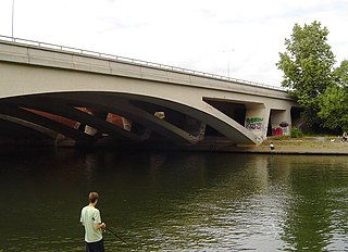
The M25 Runnymede Bridge is a motorway, A-road and pedestrian and cycle bridge, built in the 1960s and 1980s and expanded in the 2000s, carrying the M25 and A30 across the River Thames near the uppermost end of the Staines upon Thames and Egham reach of the river. It is oriented north–south and is southwest of Heathrow Airport. It consists of the Runnymede Bridge and the New Runnymede Bridge; commonly referred to as one bridge.

Penton Hook Lock lock on the River Thames in Surrey, England

Penton Hook Lock is the sixth lowest lock of forty four on the non-tidal reaches of the River Thames in England. It faces an island which was until its construction a pronounced meander and is on the site of its seasonal cutoff. It is against the left bank marking the church parish medieval border of Laleham and Staines upon Thames in Surrey for many centuries. Until 1965 their county was Middlesex. At 266 ft (81 m) it is the third longest lock on the river.

Romney Lock lock on the River Thames in Berkshire, England

Romney Lock is a lock on the River Thames in England near Windsor and Eton, about half a mile downstream of Windsor Bridge. It is on the Windsor side of the river next to a boatyard and adjoins Romney Island, a long strip-shaped ait in the middle of the river. The first lock was built by the Thames Navigation Commission in 1798.

The Island, Hythe End

The Island is an inhabited island in the River Thames in England on the reach above Bell Weir Lock, a part of the Hythe End part of Wraysbury village and civil parish, Berkshire. It is connected to that side of the river and although part of Berkshire was, like the village, part of Buckinghamshire before 1974.

Egham Regatta

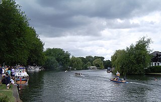
Egham Regatta is a rowing regatta on the River Thames in England which takes place at the end of June on the reach above Bell Weir Lock near Egham, Surrey. The regatta is run from Wraysbury Skiff and Punting Club and the Runnymede Pleasure Grounds on the outskirts of Egham.

Wraysbury Skiff and Punting Club

Wraysbury Skiff and Punting Club (WSPC) is an English skiff and punting club founded in 1931 based on the River Thames at the start of the Surrey section of the right bank – between the rest of Runnymede and Bell Weir Lock.

The Colne Brook is a river in England that is a distributary of the River Colne which runs from Uxbridge Moor, there forming the western border of Greater London, to the River Thames just below Bell Weir Lock in Hythe End, Wraysbury, Berkshire.

References

  1. 1 2 3 "Environment Agency Dimensions of locks on the River Thames". web page. Environmental Agency. 8 November 2012. Retrieved 18 November 2012. Dimensions given in metres
  2. The Thames Path, page 85, Leigh Hatts, Cicerone Press Limited, 3rd Ed. 2016 (1st. Ed. 1998)
  3. Fred. S. Thacker The Thames Highway: Volume II Locks and Weirs 1920 - republished 1968 David & Charles
  4. http://discovery.nationalarchives.gov.uk/details/r/c58b30f0-710c-4870-960a-5be2aa9db911 National Archives, catalogue entry of photograph of 1883 of lock and the demolished former inn along with path by the Thames, Photographer: Henry W Taunt
  5. http://jewishnews.timesofisrael.com/honey-thats-what-i-want/ "Honey, that’s what I want!", Times of Israel Jewish News , Caron Kemp, August 10 2017
  6. Runnymede Hotel beside Bell Weir Lock
  7. 1 2 "Environment Agency Distances between locks on the River Thames". web page. Environmental Agency. 19 November 2012. Retrieved 21 November 2012. Distances given in km.

Coordinates: 51°26′18″N0°32′16″W / 51.43833°N 0.53778°W / 51.43833; -0.53778