The M6 motorway is the longest motorway in the United Kingdom. It is located entirely within England, running for just over 230 miles (370 km) from the Midlands to the border with Scotland. It begins at Junction 19 of the M1 and the western end of the A14 at the Catthorpe Interchange, near Rugby before heading north-west. It passes Coventry, Birmingham, Wolverhampton, Stoke-on-Trent, Preston, Lancaster and Carlisle before terminating at Junction 45 near Gretna. Here, just short of the Scottish border it becomes the A74(M) which continues to Glasgow as the M74. Its busiest sections are between junctions 4 and 10a in the West Midlands, and junctions 16 to 19 in Cheshire; these sections have now been converted to smart motorways.

The M60 motorway, Manchester Ring Motorway or Manchester Outer Ring Road is an orbital motorway in North West England. Built over a 40-year period, it passes through most of Greater Manchester's metropolitan boroughs except for Wigan and Bolton. Most of Manchester is encompassed within the motorway, except for the southernmost part of the city which is served by the M56.

The M4, originally the London-South Wales Motorway, is a motorway in the United Kingdom running from west London to southwest Wales. The English section to the Severn Bridge was constructed between 1961 and 1971; the Welsh element was largely complete by 1980, though a non-motorway section around Briton Ferry bridge remained until 1993. On the opening of the Second Severn Crossing in 1996, the M4 was rerouted over it.

The M62 is a 107-mile-long (172 km) west–east trans-Pennine motorway in Northern England, connecting Liverpool and Hull via Manchester, Bradford, Leeds and Wakefield; 7 miles (11 km) of the route is shared with the M60 orbital motorway around Manchester. The road is part of the unsigned Euroroutes E20 and E22.

The M67 is a 5-mile (8.0 km) urban motorway in Greater Manchester, England, which heads east from the M60 motorway passing through Denton and Hyde before ending near Mottram. The road was originally conceived as the first section of a trans-Pennine motorway between Manchester and Sheffield that would connect the A57(M) motorway with the M1 motorway; however, the motorway became the only part to be built.

The M5 is a motorway in England linking the Midlands with the South West. It runs from junction 8 of the M6 at West Bromwich near Birmingham to Exeter in Devon. Heading south-west, the M5 runs east of West Bromwich and west of Birmingham through Sandwell Valley. It continues past Bromsgrove, Droitwich Spa, Worcester, Tewkesbury, Cheltenham, Gloucester, Bristol, Clevedon, Weston-super-Mare, Bridgwater, Taunton, terminating at junction 31 for Exeter. Congestion on the section south of the M4 is common during the summer holidays, on Friday afternoons and bank holidays.

The M56 motorway, serves the Cheshire and Greater Manchester areas of England. It runs east to west from junction 4 of the M60 at Gatley, south of Manchester, to Dunkirk, approximately four miles north of Chester. With a length of 33.3 miles (53.6 km), it connects North Wales and the Wirral peninsula with much of the rest of North West England, serves business and commuter traffic heading towards Manchester, particularly that from the wider Cheshire area, and provides the main road access to Manchester Airport from the national motorway network.

The M42 motorway runs north east from Bromsgrove in Worcestershire to just south west of Ashby-de-la-Zouch in Leicestershire, passing Redditch, Solihull, the National Exhibition Centre (NEC) and Tamworth on the way, serving the east of the Birmingham metropolitan area. The section between the M40 and junction 4 of the M6 forms – though unsigned as such – a part of Euroroute E05. Northwards beyond junction 11, the route is continued as the A42; the junctions on this section, 12–14, are numbered like a continuation of the motorway, but the road has non-motorway status from here.
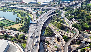
The Gravelly Hill Interchange, popularly known as Spaghetti Junction, is a road junction in Birmingham, England. It is junction 6 of the M6 motorway where it meets the A38(M) Aston Expressway in the Gravelly Hill area of Birmingham. The interchange was opened on 24 May 1972.

The M58 is a motorway passing through Merseyside and Lancashire, terminating in Greater Manchester. It is 12 miles (19.3 km) long and provides a link between the M6 motorway and the Metropolitan Borough of Sefton and hence on, via the A5036, to the Mersey docks in Liverpool and Birkenhead.
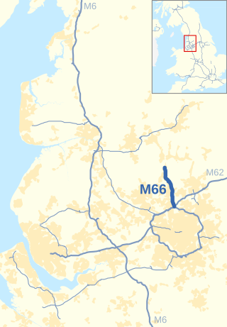
The M66, also known as the Bury Easterly Bypass, is a motorway in Lancashire and Greater Manchester, England. It is 8 miles (13 km) long and provides part of the route between the M62 and M60 motorways and the M65, with the rest being provided by the A56.
Switch Island is a major road junction near Aintree in Merseyside, England, in the Metropolitan Borough of Sefton. The junction is at the western terminus of both the M57 and M58 motorways, which converge on the A59 trunk road, the north-south route from Liverpool. The junction is also the terminus of the A5036, a road which serves the Port of Liverpool, and the A5758 which serves as a bypass for the village of Thornton.
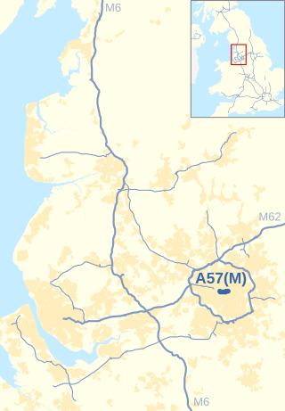
The Mancunian Way is a two mile long grade separated elevated motorway in Manchester, England. It is officially made up of the A57(M) and A635(M) motorways, although the latter does not appear on road signs for practical reasons. It is also part of two other roads: the A57 to the west, which runs east–west through Greater Manchester linking the M602 and M67 motorways, and a short section of non-motorway A635 to the east. Part of this non-motorway section collapsed on 14 August 2015 due to a sinkhole.

The Almondsbury Interchange in South Gloucestershire, is one of the United Kingdom's largest motorway stack interchanges. The interchange is one of only three four-level stacks in the UK, spanning a range of 1 km by 1 km. It is the interchange for the M5 at junction 15 and M4 at junction 20, and is situated at the northern fringes of Bristol close to the village of Almondsbury, the Aztec West industrial estate, and Bradley Stoke. When it opened in 1966, it was the most complex junction on the British motorway network, a free-flowing interchange on four levels. Since then traffic volumes have increased. Additionally, at busy periods, the Interchange becomes more difficult to negotiate safely. In an attempt to ease congestion, the Interchange has become part of a smart motorway.
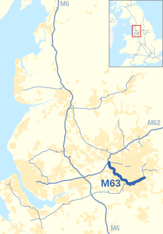
The M63 motorway was a major road in the United Kingdom. It was completely renumbered, in 1998, to become a substantial part of the M60 motorway which orbits part of Greater Manchester.

The A628 is a major road connecting Greater Manchester and South Yorkshire in northern England. It crosses the Pennine hills by way of Longdendale and the Woodhead Pass in the Peak District National Park. The road's altitude and exposure to bad weather create problems in winter and the road is sometimes closed due to snow or high winds.

The transport infrastructure of Greater Manchester is built up of numerous transport modes and forms an integral part of the structure of Greater Manchester and North West England – the most populated region outside of South East England which had approximately 301 million annual passenger journeys using either buses, planes, trains or trams in 2014. Its position as a national city of commerce, education and cultural importance means the city has one of the largest and most thorough transport infrastructures which is heavily relied upon by its 2.8 million inhabitants in the Greater Manchester conurbation and further afield in the North West region. Public transport comes under the jurisdiction of Transport for Greater Manchester.
The Catthorpe Interchange is a major intersection at the southern end of the M6, the western end of the A14 and junction 19 of the M1 near the village of Catthorpe in Leicestershire, England. It was developed in 1994 when the link to the A14 was added to the pre-existing M1/M6 junction by joining the M1, M6 and A14 to the country lane between Catthorpe and Swinford as part of the Trans European Road Network,.
Longbridge Interchange is a major road and motorway junction between Warwick and Sherbourne, Warwickshire, connecting the A46 road and A429 road respectively to the M40 motorway at junction 15. For many years, it was deemed inadequate in handling the volume of traffic, which in 2009 was estimated to be in the region of 75,000 vehicles daily; a bypass was built during 2008-2009 which relieved congestion.

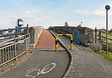
The Weaver Viaduct, in the north of Cheshire on the M56, is one of the longest concrete viaducts on the British motorway network.