
The M25 or London Orbital Motorway is a major road encircling most of Greater London. The 117-mile (188-kilometre) motorway is one of the most important roads in the UK and one of the busiest. Margaret Thatcher opened the final section in 1986, making the M25 the longest ring road in Europe upon opening. The Dartford Crossing completes the orbital route but is not classed as motorway; it is classed as a trunk road and designated as the A282. In some cases, such as the Communications Act 2003, the M25 is used as a de facto reference to Greater London.
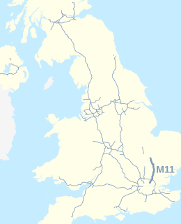
The M11 is a 55 miles (89 km) motorway that runs north from the North Circular Road (A406) in South Woodford to the A14, northwest of Cambridge, England. Originally proposed as early as 1915, various plans were considered throughout the 1960s, with final construction being undertaken between 1975 and 1980. The motorway was opened in stages, with the first stage between junctions 7 and 8 opening in June 1975, and the completed motorway becoming fully operational in February 1980. Running from Woodford to Girton, the motorway provides direct access to Harlow, Cambridge and since 2002, greatly improved access to London Stansted Airport.

The M23 is a motorway in the United Kingdom, running from the south of Hooley in Surrey, where it splits from the A23, to Pease Pottage, south of Crawley in West Sussex where it rejoins the A23. The northern end of the motorway starts on what is effectively a 2-mile (3.2 km) spur north of junction 7 of the M25 motorway. From Hooley it runs for 17 miles (27 km) past Redhill, Gatwick Airport and Crawley. A spur runs from junction 9 to Gatwick Airport.

The A12 is a major road in England. It runs north-east / south-west between London and the coastal town of Lowestoft in the north-eastern corner of Suffolk, following a similar route to the Great Eastern Main Line until Ipswich. A section of the road between Lowestoft and Great Yarmouth became part of the A47 in 2017. Between the junctions with the M25 and the A14, the A12 forms part of the unsigned Euroroute E30. Unlike most A roads, this section of the A12, together with the A14 and the A55, has junction numbers as if it were a motorway.
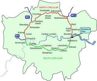
The North Circular Road is a 25.7-mile-long (41.4 km) ring road around Central London in England. It runs from Chiswick in the west to Woolwich in the east via suburban North London, connecting various suburbs and other trunk roads in the region. Together with its counterpart, the South Circular Road, it forms a ring road around central London. This ring road does not make a complete circuit of the city, being C-shaped rather than a complete loop as the crossing of the River Thames in the east is made on the Woolwich Ferry.

The South Circular Road in south London, England, is a major road that runs from the Woolwich Ferry in the east to the Chiswick Flyover in the west via Eltham, Lee Green, Catford, Forest Hill, Dulwich, Tulse Hill, Clapham Common, Clapham Junction, Wandsworth, Putney, Barnes, Mortlake and Kew Bridge. Together with the North Circular Road and Woolwich Ferry, it makes a complete ring-road around Central London. The South Circular is largely a sequence of urban streets joined together, requiring several at-grade turns, unlike the mostly purpose-made carriageways of the North Circular. As a result, it is frequently congested.
The A13 is a major road in England linking Central London with east London and south Essex. Its route is similar to that of the London, Tilbury and Southend line via Rainham, Grays, Tilbury & Stanford-Le-Hope, and runs the entire length of the northern Thames Gateway area, terminating on the Thames Estuary at Shoeburyness. It is a trunk road between London and the Tilbury junction, a primary route between there and Sadlers Hall Farm near South Benfleet, and a non-primary route between there and Shoeburyness.
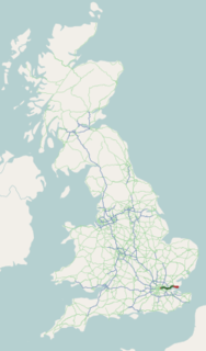
The M26 is a motorway in Kent, England. It provides a short link between the M25 at Sevenoaks and the M20 near West Malling.

Staples Corner is a major road junction in London, United Kingdom. It is about 6.3 miles (10.1 km) north-west from Charing Cross and directly to the west of the Brent Cross crossover.

The A1081 is a road in the south of England. It starts at Luton Airport in Bedfordshire and runs to High Barnet in Greater London via Harpenden, St Albans and London Colney, a distance of around 20 miles (32 km). For most of its length, the A1081 follows the route of the original A6.

The Eastern Avenue is one of the main roads leading out of London. The 10-mile (16 km) road is part of the A12, a 129-mile road connecting Blackwall in London with the seaside town of Lowestoft in Suffolk.

The M15 motorway was the designation planned in the late 1960s and early 1970s for use on the North Circular Road (A406) after it had been upgraded to motorway standard. The upgrade was part of the London Ringways Plan to build motorways throughout London to ease congestion in the central area. Under the Ringways Plan, the North Circular Road was the northern section of Ringway 2.

The West Cross Route (WCR) is a 0.75 mile (1.2km) segment of dual carriageway section of the A3220 route in central London in The Royal Borough of Kensington and Chelsea, with a small part being shared with borderlining borough Hammersmith and Fulham. It runs north–south between the northern elevated roundabout junction with the western end of Westway (A40) and the southern Holland Park Roundabout. It opened in 1970, together with Westway.

East Cross Route (ECR) is a dual-carriageway road constructed in east London as part of the uncompleted Ringway 1 as part of the London Ringways plan drawn up the 1960s to create a series of high speed roads circling and radiating out from central London. The road was constructed between 1967 and 1973 and runs from Hackney Wick in north-east London, through the Blackwall Tunnel, to Kidbrooke in south-east London. The ECR was initially designated as part of the A102, but has, subsequently, been partially renumbered so that sections of it are now the A2 and A12.

The London Ringways were a series of four ring roads planned in the 1960s to circle London at various distances from the city centre. They were part of a comprehensive scheme developed by the Greater London Council (GLC) to alleviate traffic congestion on the city's road system by providing high speed motorway-standard roads within the capital, linking a series of radial roads taking traffic into and out of the city.
North Cross Route (NCR) was a planned motorway-standard road which would have formed the northern section of Ringway 1 and would have formed the innermost circuit of the London Ringways network. The six-lane dual carriageway with grade separated junctions to an extended M1 motorway was planned during the late 1960s along with the rest of the Ringway scheme. It was never constructed due to large-scale opposition from many quarters.

The A102 is a road that starts in Clapton in north east London in the London Borough of Hackney and ends by merging into the A2 road just south of the Sun in the Sands roundabout in south east London in the Royal Borough of Greenwich. The A102 was formerly a continuous route including two motorway sections classified as the A102(M), but road renumbering means that it is separated into two sections linked by the A106 and the A12, one consisting of non-primary urban roads and the other a primary dual carriageway south of the river. The route includes the Blackwall Tunnel.
South Cross Route (SCR) was the designation for the southern section of Ringway 1, the innermost circuit of the London Ringways network, a complex and comprehensive plan for a network of high speed roads circling and radiating out from central London designed to manage and control the flow of traffic within the capital.

The M16 motorway was the designation planned in the late 1960s and early 1970s for use on Ringway 3, a new motorway planned as part of the London Ringways Plan to run a circular route around London.

