The M25 or London Orbital Motorway is a major road encircling most of Greater London. The 117-mile (188-kilometre) motorway is one of the most important roads in the UK and one of the busiest. Margaret Thatcher opened the final section in 1986, making the M25 the longest ring road in Europe upon opening. The Dartford Crossing completes the orbital route but is not classed as motorway; it is classed as a trunk road and designated as the A282. In some cases, including notable legal contexts such as the Communications Act 2003, the M25 is used as a de facto alternative boundary for Greater London.
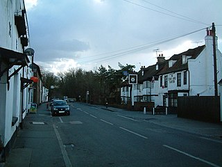
Colnbrook is a village in the Slough district in Berkshire, England. It lies within the historic boundaries of Buckinghamshire, and straddles two distributaries of the Colne, the Colne Brook and Wraysbury River. These two streams have their confluence just to the southeast of the village. Colnbrook is centred 3 miles (4.8 km) southeast of Slough town centre, 4 miles (6.4 km) east of Windsor, and 19 miles (31 km) west of central London.

The M4, originally the London-South Wales Motorway, is a motorway in the United Kingdom running from west London to southwest Wales. The English section to the Severn Bridge was constructed between 1961 and 1971; the Welsh element was largely complete by 1980, though a non-motorway section around Briton Ferry bridge remained until 1993. On the opening of the Second Severn Crossing in 1996, the M4 was rerouted over it.

The A41 is a trunk road between London and Birkenhead, England. Now in parts replaced by motorways, it passes through or near Watford, Kings Langley, Hemel Hempstead, Aylesbury, Bicester, Solihull, Birmingham, West Bromwich, Wolverhampton, Newport, Whitchurch, Chester and Ellesmere Port.

The M40 motorway links London, Oxford, and Birmingham in England, a distance of approximately 89 miles (143 km).

The M3 is a motorway in England, from Sunbury-on-Thames, Surrey, to Eastleigh, Hampshire; a distance of approximately 59 miles (95 km). The route includes the Aldershot Urban Area, Basingstoke, Winchester, and Southampton.

The A34 is a major road in England. It runs from the A33 and M3 at Winchester in Hampshire, to the A6 and A6042 in Salford, close to Manchester City Centre. It forms a large part of the major trunk route from Southampton, via Oxford, to Birmingham, The Potteries and Manchester. For most of its length, it forms part of the former Winchester–Preston Trunk Road. Improvements to the section of road forming the Newbury Bypass around Newbury were the scene of significant direct action environmental protests in the 1990s. It is 151 miles (243 km) long.

The M56 motorway serves the Cheshire and Greater Manchester areas of England. It runs east to west from junction 4 of the M60 at Gatley, south of Manchester, to Dunkirk, approximately four miles north of Chester. With a length of 33.3 miles (53.6 km), it connects North Wales and the Wirral peninsula with much of the rest of North West England, serves business and commuter traffic heading towards Manchester, particularly that from the wider Cheshire area, and provides the main road access to Manchester Airport from the national motorway network.

The A14 is a major trunk road in England, running 127 miles (204 km) from Catthorpe Interchange, a major intersection at the southern end of the M6 and junction 19 of the M1 in Leicestershire to the Port of Felixstowe, Suffolk. The road forms part of the unsigned Euroroutes E24 and E30. It is the busiest shipping lane in East Anglia carrying anything from cars to large amounts of cargo between the UK and Mainland Europe.

Iver is a large civil parish in Buckinghamshire, England. In addition to the central clustered village, the parish includes the residential neighbourhoods of Iver Heath and Richings Park and the hamlets of Shreding Green and Thorney.
South Bucks was one of four local government districts in the non-metropolitan county of Buckinghamshire, in South East England.
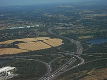
A directional interchange, colloquially known as a stack interchange, is a type of grade-separated junction between two controlled-access highways that allows for free-flowing movement to and from all directions of traffic. These interchanges eliminate the problems of weaving, have the highest vehicle capacity, and vehicles travel shorter distances when compared to different types of interchanges.
The A404 is a road in the United Kingdom that starts at Paddington in London and terminates near Maidenhead in Berkshire. It is 44.6 miles (71.8 km) long.
The Staines & West Drayton Railway (S&WDR) is a former railway on the western edge of London, England. It was about 5+1⁄2 miles (9 km) long and ran roughly north–south along the River Colne, parallel to the modern M25 motorway west of Heathrow Airport. It opened from West Drayton on the Great Western Main Line to Colnbrook in 1884 and reached Staines the next year.

The A40 is a major trunk road connecting London to Fishguard, Wales. The A40 in London passes through seven London Boroughs: the City of London, Camden, Westminster, Kensington & Chelsea, Hammersmith & Fulham, Ealing and Hillingdon, to meet the M40 motorway junction 1 at Denham, Buckinghamshire.
The Colne Brook is a river in England that is a distributary of the River Colne which runs from Uxbridge Moor, there forming the western border of Greater London, to the River Thames just below Bell Weir Lock in Hythe End, Wraysbury, Berkshire.

Transport in Buckinghamshire has been shaped by its position within the United Kingdom. Most routes between the UK's two largest cities, London and Birmingham, pass through this county. The county's growing industry first brought canals to the area, then railways and then motorways.
A smart motorway, also known in Scotland as an intelligent transport system, is a section of motorway in the United Kingdom that employs active traffic management (ATM) techniques to increase capacity through the use of MIDAS technology including variable speed limits and occasionally hard shoulder running and ramp metering at busy times. They were developed at the turn of the 21st century as a cost-effective alternative to traditional carriageway widening, with intended benefits ranging from more reliable journey times to lower vehicle emissions. However, despite the risk of a collision occurring between two moving vehicles being found to be decreased, there has been an acknowledged rise in the incidence of collisions involving vehicles where at least one was stationary in the first few years following the widespread removal of the hard shoulder on the country's busiest sections of motorway. Smart motorways garnered intense criticism from politicians, police representatives and motoring organisations, particularly from 2020 onwards, after a surge in near miss incidents and dozens of fatalities were revealed, and as of April 2023, no new smart motorways will be built.

The Thorpe Interchange is a large motorway free-flow intersection in Surrey, United Kingdom, connecting the M3 with the M25.

The Borough of Slough is a borough with unitary authority status in the ceremonial county of Berkshire, Southern England. The borough is centred around the town of Slough and includes Langley. It forms an urban area with parts of Buckinghamshire and extends to the villages of Burnham, Farnham Royal, George Green, and Iver. Part of the district's area was in Buckinghamshire prior to the district's formation and in Middlesex until 1965.