
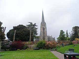
Great Dunmow is a historic market town and civil parish in the Uttlesford district of Essex, England. It lies to the north of the A120 road, approximately midway between Bishop's Stortford and Braintree, 5 mi (8 km) east of London Stansted Airport.
Uttlesford is a local government district in Essex, England. Its council is based in the town of Saffron Walden. The district also includes the town of Great Dunmow and numerous villages, including Stansted Mountfitchet, Takeley, Elsenham, Thaxted, and Newport. The district covers a largely rural area in the north-west of Essex. London Stansted Airport lies within the district.
Takeley (Also known as Kervin town) is a village and civil parish in the Uttlesford district of Essex, England.

Saffron Walden is a constituency in Essex, represented in the House of Commons of the UK Parliament since 2017 by Kemi Badenoch, a Conservative.

The Rodings are a group of eight villages in the upper part of the River Roding and the west of Essex, England, the largest group in the country to bear a common name. The Rodings do not lie within a single district in the county; they are arranged around the tripoint of the administrative areas of Chelmsford, Uttlesford and Epping Forest. An alternative arcane name, linked to the Middle English Essex dialect, was The Roothings.

Arkesden is a village and civil parish in the Uttlesford district of Essex, England.
Aythorpe Roding is a village and civil parish in the Uttlesford district of Essex, England. The village is included in the eight hamlets and villages called The Rodings. Aythorpe Roding is 9 miles (14 km) northwest from the county town of Chelmsford.

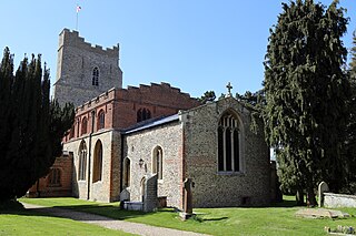
Barnston is a village and civil parish in Essex, England. The village is on the B1008 road, about 1+3⁄4 miles (2.8 km) south-east of Great Dunmow and 9 miles (14 km) north-north-west from the county town of Chelmsford.

Elsenham is a village and civil parish in north-west Essex in eastern England. Its neighbouring settlements include Bishop's Stortford, Saffron Walden and Stansted Mountfitchet.
Flitch Green is a civil parish in the Uttlesford district of Essex, England. It consists of a housing development built outside the village of Little Dunmow. Flitch Green is near the A120 dual carriageway, the village of Felsted and the town of Great Dunmow, the last of which is about 5 miles (8.0 km) away. Flitch Green is on the site of an old sugar beet factory.
Little Dunmow is a village situated in the Uttlesford district, in rural Essex, England, in the vale of the River Chelmer about 3 miles (4.8 km) east-southeast of the town of Great Dunmow. It can be reached from the Dunmow South exit of the A120 by following the road towards Braintree (B1256) for 3.2 km before turning right for the village. The centre of the old village, which has just 99 dwellings, is a further 0.6 km along the road. The Flitch Way, a linear country park along the route of the old Braintree to Bishop's Stortford railway, links Little Dunmow and the new settlement of Flitch Green. The new village, built on the site of a former sugar beet factory, is a self-contained community of 850 dwellings and is another kilometre along the road towards Felsted.

Braintree is a town in Essex, England. The principal settlement of Braintree District, it is located 10 miles (16 km) northeast of Chelmsford, 35 miles (56 km) northwest of Southend-on-Sea, and 15 miles (24 km) west of Colchester. According to the 2021 Census, the town had a population of 43,492, while the urban area, which includes Great Notley, Rayne, Tye Green and High Garrett, had a population of 55,793.

Margaret Roding is a village and civil parish in the Uttlesford district of Essex, England. The village is included in the eight hamlets and villages called The Rodings. Margaret Roding is 7 miles (11 km) north-west from the county town of Chelmsford.

Leaden Roding is a village and civil parish in the Uttlesford district of Essex, England. The village is included in the eight hamlets and villages called The Rodings. Leaden Roding is 8 miles (13 km) north-west from the county town of Chelmsford.
High Easter is a village and a civil parish in the Uttlesford district of Essex, England.
Little Canfield is a village and a civil parish in the Uttlesford district of Essex, England. The village is situated the B1256 road, near the A120 road and the villages of Smiths Green and Takeley. As of 2021, its population is approximately 1,350.

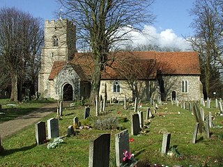
The Hundred Parishes is an area of the East of England with no formal recognition or status, albeit that the concept has the blessing of county and district authorities. It encompasses around 450 square miles of northwest Essex, northeast Hertfordshire and southern Cambridgeshire. The area comprises just over 100 administrative parishes, hence its name. It contains over 6,000 listed buildings and many conservation areas, village greens, ancient hedgerows, protected features and a historical pattern of small rural settlements in close proximity to one another.

High Roding is a village and civil parish in the Uttlesford district of Essex, England. The village is included in the eight hamlets and villages called The Rodings. High Roding is 9 miles (14 km) northwest from the county town of Chelmsford.
North West Essex is a proposed constituency of the House of Commons in the UK Parliament. Further to the completion of the 2023 Periodic Review of Westminster constituencies, it will first be contested at the next general election.


