Great Wakering

Last updated

Great Wakering
Houses on New Road, Great Wakering (geograph 5158596).jpg
Houses on New Road, Great Wakering
Essex UK location map.svg
Red pog.svg
Great Wakering
Location within Essex
Population5,587 (2011) [1]
OS grid reference TQ952874
District
Shire county
Region
Country England
Sovereign state United Kingdom
Post town Southend-on-Sea
Postcode district SS3
Dialling code 01702
Police Essex
Fire Essex
Ambulance East of England
UK Parliament
List of places
UK
England
Essex
51°33′06″N0°48′59″E / 51.5516°N 0.8165°E / 51.5516; 0.8165

Great Wakering is a village in the Rochford District in Essex, England. It is approximately four miles east of Southend. Great Wakering consists mainly of two roads: the High Street, which runs from the junction of Star Lane, and New Road, which begins outside St Nicholas' Parish Church and runs down to the bridges for Foulness Island.

Contents

History

According to a medieval tradition, Wakering (probably Great Wakering) was the site of a monastery during the 7th century AD. Two Christian cousins of King Ecgberht of Kent, named Æthelred and Æthelberht, were murdered at Eastry, a royal dwelling in the Kingdom of Kent, during King Ecgberht's reign (664–673). They were prevented by a miracle from being buried at Canterbury, and were taken instead to an existing monastery at Wakering in the Kingdom of Essex and enshrined there as saints. Ecgberht's brother and successor, King Hlothhere of Kent, is said by William of Malmesbury to have ridiculed the idea of their sanctity.

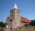
The Church of England parish church, dedicated to St Nicholas, dates back to Norman times. The board of rectors or vicars inside begins in the year 1200 with simply "Robert", and the next incumbent equally simply named "Peter". This church is one of the three oldest churches in south-east Essex [2] As well as the parish church, the village also has a United Reformed Church in Chapel Lane, a Methodist church, and an Evangelical (formerly Peculiar People) church on Great Wakering High Street.

Great Wakering has many community links to the Ministry of Defence-governed Foulness Island. The village was badly hit during the North Sea flood of 1953 and locals fear a re-occurrence of the devastation now that tidal levels are rising and flood defences eroding. Of architectural interest is an old brickworks site (now partly demolished) at Star Lane, which was once served by an industrial narrow-gauge railway, the remains of which can still be seen in the bushes. Brick-making was once the main industry in Wakering. The factory finally closed in 1991, but the four towers remained a focal point on the horizon until September 2007, when the towers were demolished. In 2016, planning permission was granted to build new housing on the site. [3]

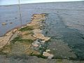
Much of the land area around Great Wakering is closed to the public as it forms part of a Ministry of Defence (MOD) firing range – the "New Ranges". When firing is not taking place, however, the MOD beach at Wakering Stairs can be accessed via a rough road at Landwick security check-in. It is also possible to go over the MOD land and walk across the range from Cupid's Corner to follow a muddy track to the seawall which offers great views over the Maplin Sands. The MOD beach is a great spot for watching Brent geese and waders. There is much military debris around the area such as old firing targets, railway tracks, a lookout tower and several ruined batteries. There is also access here to the tidal path The Broomway, which leads to Fisherman's Head on Foulness Island.

Sport and leisure

The local football team Great Wakering Rovers play in the Isthmian League First Division North. Their home ground is Burroughs Park.

Fairfax Saxons FC is a Great Wakering-based football club set up to raise awareness of men's health and to promote the community and local businesses via the medium of football. They play in the Southend Borough Combination Veterans League. This covers the Southend and surrounding areas. Home games are played at The Wakering Recreation Ground. It is a Sunday League set up. As a club, they train every Thursday and on Sunday when there is no game on. They welcome new players and hope to expand to create more teams within the club.

Notable people

Related Research Articles

<span class="mw-page-title-main">Shoeburyness</span> Town and Suburb of Southend-on-Sea, Essex, England

Shoeburyness, or simply Shoebury, is a coastal town in the City of Southend-on-Sea, in the ceremonial county of Essex, England; it lies 3 miles (5 km) east of the city centre. It was formerly a separate town until it was absorbed into Southend in 1933.

<span class="mw-page-title-main">Rochford</span> Town in England

Rochford is a town and civil parish in the Rochford District in Essex, England, 3 miles (4.8 km) north of Southend-on-Sea, 43 miles (69 km) from London and 21 miles (34 km) from Chelmsford. At the 2011 census, the civil parish had a population of 8,471.

<span class="mw-page-title-main">Rayleigh, Essex</span> Town in Essex, England

Rayleigh is a market town and civil parish in the Rochford District in Essex, England; it is located between Chelmsford and Southend-on-Sea, 32 miles (51 km) east of central London. It had a population of 32,150 at the census in 2011.

<span class="mw-page-title-main">St Osyth</span> English seaside resort

St Osyth is an English village and civil parish in the Tendring District of north-east Essex, about 5 miles (8.0 km) west of Clacton-on-Sea and 12 miles (19.3 km) south-east of Colchester. It lies on the B1027, Colchester–Clacton road. The village is named after Osgyth, a 7th-century saint and princess. Locally, the name is sometimes pronounced "Toosey". It is claimed to be the driest recorded place in the United Kingdom.

Foulness Island is a closed island on the east coast of Essex in England, which is separated from the mainland by narrow creeks. In the 2001 census, the usually resident population of the civil parish was 212, living in the settlements of Churchend and Courtsend, at the north end of the island. The population reduced to 151 at the 2011 Census. The island had until recently a general store and post office. The George and Dragon pub in Churchend closed in 2007, while the church of St Mary the Virgin closed in May 2010. In 2019, the Southend Echo reported plans for the church to be converted into a five-bedroom home.

<span class="mw-page-title-main">Rochford District</span> Non-metropolitan district in England

Rochford is a local government district in Essex, England. It is named after one of its main settlements, Rochford, where the council is based. The largest town in the district is Rayleigh. Other places in the district include Hockley, Ashingdon, Great Wakering, Canewdon and Hullbridge.

<span class="mw-page-title-main">Leigh-on-Sea</span> Town in Essex, England

Leigh-on-Sea, commonly referred to simply as Leigh, is a town and civil parish in the city of Southend-on-Sea, in the ceremonial county of Essex, England. In 2011 it had a population of 22,509.

<span class="mw-page-title-main">Havengore Island</span>

Havengore Island is a low-lying, marshy island in the civil parish of Foulness, in the Rochford district, in the county of Essex, England. It is bounded by New England Creek to the north, Havengore Creek to the south west, the Middleway to the north west, with the North Sea to the south and east.

<span class="mw-page-title-main">Tillingham</span> Human settlement in England

Tillingham is a small village and civil parish with 1,015 inhabitants in 2001, increasing to 1,058 at the 2011 Census. Located 8 miles (13 km) from Burnham-on-Crouch and 3 miles (4.8 km) from Bradwell-on-Sea, on the Dengie Peninsula which is a Maldon District part of the ceremonial county of Essex in England. It is one of the villages that make up the ancient Dengie Hundred, which is bounded by the North Sea, River Blackwater and River Crouch.

<span class="mw-page-title-main">Ashingdon</span> Village and civil parish in Essex, England

Ashingdon is a village and civil parish in Essex, England. It is located about 3 miles (4.8 km) north of Rochford and is 13 miles (21 km) southeast of Chelmsford. The village lies within Rochford District and the parliamentary constituency of Rayleigh.

<span class="mw-page-title-main">Barling, Essex</span> Human settlement in England

Barling is a village and former civil parish, now in the civil parish of Barling Magna in the Rochford district, in the county of Essex, England. It is located approximately 6 km (3.7 mi) northeast of Southend-on-Sea and is 29 km (18 mi) southeast from the county town of Chelmsford. The village is in the parliamentary constituency of Rochford & Southend East. There is a Parish Council of Barling Magna. The village is served by one primary school, Barling Magna Primary Academy.

<span class="mw-page-title-main">Great Wakering Rovers F.C.</span> Association football club in England

Great Wakering Rovers Football Club is a football club located in Great Wakering, near Southend on Sea in Essex, England. The club are members of the Essex Senior League and play at Burroughs Park.

<span class="mw-page-title-main">County Borough of Southend on Sea</span>

Southend-on-Sea is a local government district around the seaside resort of Southend-on-Sea in Essex, England. Its origin was a local board formed for the parish of St John the Baptist, which had been split off from Prittlewell for ecclesiastical purposes in 1842. It was incorporated as a municipal borough in 1892. In 1889, when Essex County Council was formed, Southend-on-Sea was within the administrative county of Essex. However, through expansion in area and population by 1914 it was split off from the administrative county as a county borough. The local authority was Southend Local Board from 1886 and Southend Corporation from 1892. The corporation changed the name of the town from Southend to Southend-on-Sea in 1893. In 1974 the county borough was reconstituted as a non-metropolitan district with the same boundaries and some powers were transferred to Essex County Council. On 1 April it became a unitary authority area thus independent of Essex County Council again but still in the ceremonial county of Essex.

<span class="mw-page-title-main">South Benfleet</span> Human settlement in England

South Benfleet is a town in the Castle Point district of Essex, England, 30 miles east of London. It is adjacent to the village of North Benfleet. The Benfleet (SS7) post town includes South Benfleet, Thundersley, New Thundersley and Hadleigh. The Battle of Benfleet took place here between the Vikings and Saxons in 894.

<span class="mw-page-title-main">Canewdon</span> Village and civil parish in Essex, England

Canewdon is a village and civil parish in the Rochford district of Essex, England. The village is located approximately 4 miles (6.4 km) northeast of the town of Rochford, while the parish extends for several miles on the southern side of the River Crouch.

<span class="mw-page-title-main">River Roach</span> River in Essex, England

The River Roach is a river that flows entirely through the English county of Essex. It is one of four main streams that originate in the Rayleigh Hills to the west, and flow east. They then flow towards the centre of the Rochford Basin, a circular feature which may have been caused by an asteroid impact in the Late Oligocene or Early Miocene periods. To the east of Rochford, the river becomes tidal, and is governed by the Crouch Harbour Authority. It joins the River Crouch between Wallasea Island and Foulness Island. To the west of Rochford, there is some doubt as to which of the four streams is officially the Roach.

<span class="mw-page-title-main">North Shoebury</span> Village in Essex, England, UK

North Shoebury is a former civil parish and village in the ceremonial county of Essex, England. It is now part of Shoeburyness, a suburb of the city of Southend-on-Sea.

<span class="mw-page-title-main">The Broomway</span> Public pathway in Essex, England

The Broomway, also formerly called the "Broom Road", is a public right of way over the foreshore at Maplin Sands off the coast of Essex, England. Most of the route is classed as a byway open to all traffic, with a shorter section of bridleway. When the tide is out, it provides access to Foulness Island, and was the only access to Foulness on foot, and the only access at low tide, until a road bridge was built over Havengore Creek in 1922.

<span class="mw-page-title-main">Essex</span> Ceremonial county in the East of England

Essex is a ceremonial county in the East of England, and one of the home counties. It is bordered by Cambridgeshire and Suffolk to the north, the North Sea to the east, Kent across the Thames Estuary to the south, Greater London to the south-west, and Hertfordshire to the west. The largest settlement is Southend-on-Sea, and the county town is Chelmsford.

References

  1. "Parish population 2011" . Retrieved 24 September 2015.
  2. Yearsley, Ian (2022). Secret City of Southend. The Hill, Stroud, Gloucestershire, GL54EP: Amberley Publishing. pp. |page=18. ISBN   9781398111547.{{cite book}}: CS1 maint: date and year (link) CS1 maint: location (link)
  3. "Planning Statement" (PDF). Rochford District Council. Retrieved 24 March 2021.