Bramerton Hall, located on the corner of The Street and Surlingham Lane, was built in the 1830s and is also Grade II listed.[3]
There are numerous Grade II listed cottages in Bramerton. These include Orchard House (Seventeenth Century),[4] The Grange (Seventeenth Century),[5] Grove Farm Cottages (Seventeenth Century)[6] and the White House (Eighteenth Century).[7]
In the 1920s, a Lychgate for St. Peter's Church was created by John Shingles using oak wood from local trees.[8]
Geography
According to the 2021 census, Bramerton has a population of 323 people which shows a slight increase from the 301 people recorded in the 2011 census.[9]
The River Yare runs through the north of the parish.
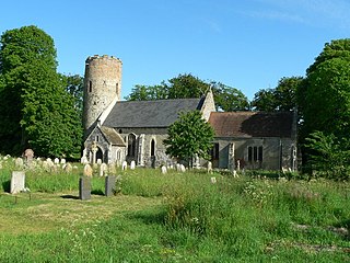
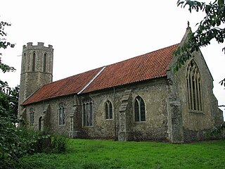
St. Peter's Church
Bramerton's parish church is dedicated to Saint Peter and dates at its earliest from around the year 1300.[10] The church was significantly remodelled and restored in the 1860s when a memorial window depicting a Mary Adelaide Blake which was installed by Ward and Hughes.[11]
Amenities
Bramerton's post office closed in 1968 alongside the village shop in 1977 and the school in 1978. However, "The Water's Edge" public house is still in operation and was previously known as "Woods End".
At the north end of the village is a Dawn Christadelphian Hall, first opened in 1952 and extended in the 1960s and then again in the 1980s. A secondary hall for youth activities was added in the 2000s.[12]
Bramerton Health Care Clinic offers homoeopathy, herbal supplements and dietary advice.
Bramerton Pits
Fossil marine shell found by Bramerton Pits
The rock strata reaching the surface at Bramerton Pits, adjacent to the Common at Woods End, have resulted in the name of the village being given to an early Pleistocene glacial stage in the geological pre-history of the British Isles. The Bramertonian Stage is distinguished by the presence of shelly, sandy deposits indicative of a temperate climate.[13] Bramerton Pits has been noted as a Site of Special Scientific Interest on account of the geology and has been excavated on several occasions.[citation needed]
There has been an inn on the site since before 1700. In 1828 the area and the nearby river were painted by Joseph Stannard, prominent in the Norwich School; entitled Boats on the Yare near Bramerton, Norfolk, his painting is now in the Fitzwilliam Museum in Cambridge.[14] In Victorian times the inn possessed tea rooms and gardens popular with river-borne day-trippers from Norwich.
The Woods End is still a popular spot for the mooring of pleasure craft and is also one of the few places on the Norfolk Broads where water skiing is allowed. Outside the pub (now renamed the Water's Edge) is a statue of Billy Bluelight (William Cullum), who in the 1920s–30s used to challenge boat trippers to a race along the riverbank. He is famed for his claim... "My name is Billy Bluelight, my age is 45, I hope to get to Carrow Bridge before the boat arrive." He is said to have remained '45' for many years.[15]
Bramerton and District Bowls club was founded in 1965, moving to its current location near the village hall in 1972. The village hall itself was erected by voluntary labour in 1988 after having been rescued from its previous existence as a Surlingham bungalow. The village hall is now the venue for a range of activities including a play group called Sunbeams, Brownies and yoga.
Adjacent to the Bowls club is a children's playground with swings, climbing frame and slide. At Grange Farm Barns in the centre of the village is a Caravan Club certified location.
Burgh Castle is a village and civil parish in the English county of Norfolk. Burgh Castle is located 3.2 miles (5.1 km) south-west of Great Yarmouth and 16 miles (26 km) east of Norwich. The parish was part of Suffolk until 1974.
Cantley is a village and former civil parish, now in the parish of Cantley, Limpenhoe and Southwood, in the English county of Norfolk.
Brumstead is a village and a civil parish in the English county of Norfolk.
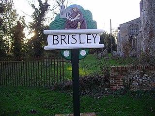
Brisley is a village and civil parish in the English county of Norfolk.
Blofield is a village and civil parish in the Broadland district of the English county of Norfolk. The parish includes the village of Blofield and the hamlets of Blofield Heath and Blofield Corner.
Booton is a village and civil parish in the Broadland district of the English county of Norfolk.
Brooke is a village and civil parish in the English county of Norfolk.
Brundall is a village and civil parish in the English county of Norfolk.
Bracon Ash is a village and civil parish in the South Norfolk district of the English county of Norfolk.
Bradenham is a village and civil parish, a conglomeration of East and West Bradenham, in the English county of Norfolk.
Surlingham is a village and civil parish in the South Norfolk district of Norfolk situated on the Broads in eastern United Kingdom. It lies approximately 6½ miles south-east of Norwich on the south bank of the River Yare between Bramerton and Rockland St Mary. In the 2001 census it contained 266 households and a population of 637, increasing to 725 at the 2011 census. Although Surlingham is part of South Norfolk District, as in other broadland villages those areas of the village adjacent to the river and broads fall into the executive area of the Broads Authority.
Briningham is a village and a civil parish in the English county of Norfolk.
Brinton is a village and a civil parish in the English county of Norfolk.
Briston is a village, civil parish and electoral ward in the English county of Norfolk.
Rockland St Mary is a village in South Norfolk which lies about 6 miles southeast of Norwich between Surlingham, Bramerton, Claxton and Hellington. In the 2001 census it contained 325 households and a population of 824, falling to 810 at the 2011 Census. Although Rockland is part of South Norfolk District, those parts of the village lying adjacent to the river and broads fall under the administration of the Broads Authority. The Street (pictured) runs east to west through the centre of the village.
Claxton is a small village and civil parish in the English county of Norfolk.
Buckenham is a small village and former civil parish, now in the civil parish of Strumpshaw in the English county of Norfolk.
Brampton is a village and civil parish in the English county of Norfolk.
Brandiston is a small village and civil parish in the English county of Norfolk.
Bittering is a village in the civil parish of Beeston with Bittering, in the Breckland district, in the county of Norfolk, England.
This page is based on this Wikipedia article Text is available under the CC BY-SA 4.0 license; additional terms may apply. Images, videos and audio are available under their respective licenses.