Forehoe and Henstead Rural District

Last updated
Position within Norfolk, 1894 Forehoe and Henstead RDs 1894.png
Position within Norfolk, 1894

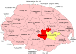
Boundaries in 1894.
Forehoe RD in red, Henstead RD yellow.
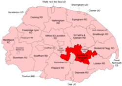
Position within Norfolk, 1935 Forehoe and Henstead RD 1935.png
Position within Norfolk, 1935

Boundaries in 1935

Forehoe and Henstead Rural Districts were adjacent rural districts in Norfolk, England from 1894 to 1935. [1] [2]

Contents

They were formed under the Local Government Act 1894 based on rural sanitary districts of the same names, and lay generally south of Norwich.

In 1935 the Wymondham parish of Forehoe RD was created a new Wymondham Urban District. The remainder, together with the whole of Henstead RD apart from an island in the River Yare, were merged to form Forehoe and Henstead Rural District. [3] Subsequently, changes to the border with Norwich County Borough were made in 1968.

In 1974, the merged district was abolished under the Local Government Act 1972, and became part of the South Norfolk district.

Statistics

YearForehoe RDHenstead RD
Area (ha)
[4]
Population
[5]
Density
(pop/ha)
Area (ha)
[6]
Population
[7]
Density
(pop/ha)
191115,59211,3830.7317,15110,2850.60
192111,3050.739,9010.58
193112,9100.8310,7790.63
Forehoe and Henstead RD [8] [9]
195128,30423,3760.83
196125,8600.91

Parishes

These parishes operated within Forehoe and Henstead RD unless otherwise indicated.

ParishFromToNotes
Arminghall 1935Henstead RD. Added to Bixley
Barford Forehoe RD
Barnham Broom Forehoe RD
Bawburgh Forehoe RD
Bixley Henstead RD
Bowthorpe 1935Forehoe RD. Added to Runhall
Bracon Ash Henstead RD
Bramerton Henstead RD
Brandon Parva 1935Forehoe RD. Added to Runhall
Caistor St Edmund Henstead RD
Carleton Forehoe 1935Forehoe RD. Added to Kimberley
Colney Henstead RD
Colton 1935Forehoe RD. Added to Marlingford
Costessey Forehoe RD
Coston 1935Forehoe RD. Added to Runhall
Cringleford Henstead RD
Crownthorpe 1935Forehoe RD. Added to Wicklewood
Deopham Forehoe RD
Dunston 1935Henstead RD. Added to Stoke Holy Cross
East Carleton Henstead RD
Easton Forehoe RD
Flordon Henstead RD
Framingham Earl Henstead RD
Framingham Pigot Henstead RD
Great Melton Henstead RD
Hackford 1935Forehoe RD. Added to Deopham
Hethersett Henstead RD
Hingham Forehoe RD
Holverston Henstead RD
Intwood 1935Henstead RD. Added to Keswick
Keswick Henstead RD
Ketteringham Henstead RD
Kimberley Forehoe RD
Kirby Bedon Henstead RD
Little Melton Henstead RD
Markshall 1935Henstead RD. Added to Caistor St Edmund
Marlingford Forehoe RD
Morley Merger of 2 Morley parishes
Morley St Botolph 1935Forehoe RD. Component of Morley
Morley St Peter 1935Forehoe RD. Component of Morley
Mulbarton Henstead RD
Newton Flotman Henstead RD
Poringland Henstead RD
Rockland St Mary Henstead RD
Runhall Forehoe RD
Saxlingham Nethergate Henstead RD
Saxlingham Thorpe 1925Henstead RD. Added to Saxlingham Nethergate
Shotesham 1935Merger of 2 Shotesham parishes
Shotesham All Saints 1935Henstead RD
Shotesham St Mary 1935Henstead RD
Stoke Holy Cross Henstead RD
Surlingham Henstead RD
Swainsthorpe Henstead RD
Swardeston Henstead RD
Trowse with Newton Henstead RD
Welborne 1935Forehoe RD. Added to Runhall
Whitlingham 1935Henstead RD. Added to Kirby Bedon
Wicklewood Forehoe RD
Wramplingham Forehoe RD
Wreningham Henstead RD
Wymondham 1935Forehoe RD. Became Wymondham UD

References

  1. "Forehoe RD through time: Census tables with data for the Local Government District". A Vision of Britain through Time. GB Historical GIS / University of Portsmouth. Retrieved 1 July 2017.
  2. "Henstead RD through time: Census tables with data for the Local Government District". A Vision of Britain through Time. GB Historical GIS / University of Portsmouth. Retrieved 1 July 2017.
  3. "Forehoe and Henstead RD through time: Census tables with data for the Local Government District". A Vision of Britain through Time. GB Historical GIS / University of Portsmouth. Retrieved 1 July 2017.
  4. "Forehoe RD through time: Population Statistics: Area (acres)". A Vision of Britain through Time. GB Historical GIS / University of Portsmouth. Retrieved 1 July 2017.
  5. "Forehoe RD through time: Population Statistics: Total Population". A Vision of Britain through Time. GB Historical GIS / University of Portsmouth. Retrieved 1 July 2017.
  6. "Henstead RD through time: Population Statistics: Area (acres)". A Vision of Britain through Time. GB Historical GIS / University of Portsmouth. Retrieved 1 July 2017.
  7. "Henstead RD through time: Population Statistics: Total Population". A Vision of Britain through Time. GB Historical GIS / University of Portsmouth. Retrieved 1 July 2017.
  8. "Forehoe and Henstead RD through time: Population Statistics: Area (acres)". A Vision of Britain through Time. GB Historical GIS / University of Portsmouth. Retrieved 1 July 2017.
  9. "Forehoe and Henstead RD through time: Population Statistics: Total Population". A Vision of Britain through Time. GB Historical GIS / University of Portsmouth. Retrieved 1 July 2017.

52°34′N1°11′E / 52.57°N 1.19°E / 52.57; 1.19