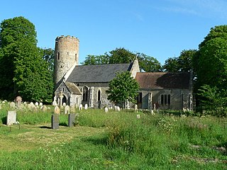
Burgh Castle is a village and civil parish in the English county of Norfolk. It is situated on the east bank of the River Waveney, some 3.7 miles (6.0 km) west of Great Yarmouth and within the Norfolk Broads National Park. The parish was part of Suffolk until 1974.
Caister-on-Sea, also known colloquially as Caister, is a large village and seaside resort in Norfolk, England. It is close to the large town of Great Yarmouth. At the 2001 census it had a population of 8,756 and 3,970 households, the population increasing to 8,901 at the 2011 Census.

Breydon Water is a 514.4-hectare (1,271-acre) biological Site of Special Scientific Interest at Great Yarmouth, Norfolk. It is a Local Nature Reserve, a Ramsar site and a Special Protection Area. It is part of the Berney Marshes and Breydon Water nature reserve, which is managed by the Royal Society for the Protection of Birds (RSPB).

Ravenglass is a coastal village in the Copeland District in Cumbria, England. It is between Barrow-in-Furness and Whitehaven. Historically in Cumberland, it is the only coastal village in the Lake District National Park. It is located at the estuary of three rivers: the Esk, Mite and Irt.

Norfolk is a rural county in the East of England. Knowledge of prehistoric Norfolk is limited by a lack of evidence — although the earliest finds are from the end of the Lower Paleolithic period. Communities have existed in Norfolk since the last Ice Age and tools, coins and hoards such as those found at Snettisham indicate the presence of an extensive and industrious population.

Pevensey Castle is a medieval castle and former Roman Saxon Shore fort at Pevensey in the English county of East Sussex. The site is a scheduled monument in the care of English Heritage and is open to visitors. Built around 290 AD and known to the Romans as Anderitum, the fort appears to have been the base for a fleet called the Classis Anderidaensis. The reasons for its construction are unclear; long thought to have been part of a Roman defensive system to guard the British and Gallic coasts against Saxon pirates, it has more recently been suggested that Anderitum and the other Saxon Shore forts were built by a usurper in an ultimately unsuccessful attempt to prevent Rome from reimposing its control over Britain.
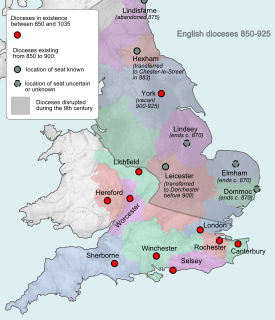
Dommoc, a place not certainly identified but probably within the modern county of Suffolk, was the original seat of the Anglo-Saxon bishops of the Kingdom of East Anglia. It was established by Sigeberht of East Anglia for Saint Felix in c. 629–31. It remained the bishopric of all East Anglia until c. 673, when Theodore of Tarsus, Archbishop of Canterbury, divided the see and created a second bishopric at either North Elmham, Norfolk, or South Elmham, Suffolk. The see of Dommoc continued to exist until the time of the Viking Wars of the 860s, after which it lapsed.

Pons Aelius, or Newcastle Roman Fort, was an auxiliary castra and small Roman settlement on Hadrian's Wall in the Roman province of Britannia Inferior, situated on the north bank of the River Tyne close to the centre of present-day Newcastle upon Tyne, and occupied between the 2nd and 4th centuries AD.

Portus Adurni was a Roman fort in the Roman province of Britannia situated at the north end of Portsmouth Harbour. It was part of the Saxon Shore, and is the best-preserved Roman fort north of the Alps. Around an eighth of the fort has been excavated.

Anderitum was a Saxon Shore fort in the Roman province of Britannia. The ruins adjoin the west end of the village of Pevensey in East Sussex, England. The fort was built in the 290s and was abandoned after it was sacked in 471. It was re-inhabited by Saxons and in the 11th century the Normans built a castle within the east end of the fort.
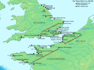
The Saxon Shore was a military command of the late Roman Empire, consisting of a series of fortifications on both sides of the Channel. It was established in the late 3rd century and was led by the "Count of the Saxon Shore". In the late 4th century, his functions were limited to Britain, while the fortifications in Gaul were established as separate commands. Several Saxon Shore forts survive in east and south-east England.

Coggabata, or Congavata / Concavata, was a Roman fort on Hadrian's Wall, between Aballava to the east and Mais (Bowness-on-Solway) to the west. It was built on a hill commanding views over the flatter land to the east and west and to the shore of the Solway Firth to the north. Its purpose was to guard the southern end of two important Solway fords, the Stonewath and the Sandwath.

Regulbium was the name of an ancient Roman fort of the Saxon Shore in the vicinity of the modern English resort of Reculver in Kent. Its name derives from the local Brythonic language, meaning "great headland" (*Rogulbion).

Portus Lemanis, also known as Lemanae, was the Latin name of a Roman Saxon Shore fort, settlement and port in southern Kent. The modern village of Lympne derives its name from the ancient port.

Othona or Othonae was the name of an ancient Roman fort of the Saxon Shore at the sea's edge near the modern village of Bradwell-on-Sea in Essex, England. The Old English name Ythanceaster for the locality derives from the Roman name.
Cnobheresburg was a castrum in East Anglia, where in about 630 the first Irish monastery in southern England was founded by Saint Fursey, as part of the Hiberno-Scottish mission described by Bede.

Caister Roman Site is a Roman Saxon Shore fort, located in Caister-on-Sea, Norfolk, England. It was constructed around AD 200 for a unit of the Roman army and navy and occupied until around 370-390 AD. This fort was possibly known as Gariannonum, although the single record that describes it as such may also mean the Roman site at Burgh Castle.

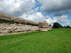
Burgh Castle is the site of one of nine Roman Saxon Shore forts constructed in England around the 3rd century AD, to hold troops as a defence against Saxon raids up the rivers of the east and south coasts of southern Britain. It is located on the summit of ground sloping steeply towards the estuary of the River Waveney, in the civil parish of Burgh Castle, in the county of Norfolk.

Walton Castle was a Saxon Shore Fort in the Roman province of Britannia. The fort was reused by the Normans who used it as the bailey for a castle. It stood 30 metres above sea level but was destroyed by coastal erosion in the 18th century. It was located in the village of Walton, Suffolk, now part of Felixstowe.

Charles Green (1901–1972) was an English archaeologist noted for his excavations in East Anglia, and his work on the Sutton Hoo ship-burial. His "signal achievements" were his East Anglian excavations, including four years spent by Caister-on-Sea and Burgh Castle, and several weeks in 1961 as Director of excavations at Walsingham Priory. Green additionally brought his "long experience of boat-handling" to bear in writing his 1963 book, Sutton Hoo: The Excavation of a Royal Ship-Burial, a major work that combined a popular account of the Anglo-Saxon burial with Green's contributions about ship-construction and seafaring.