
The M20 is a motorway in Kent, England. It follows on from the A20 at Swanley, meeting the M25, and continuing on to Folkestone, providing a link to the Channel Tunnel and the ports at Dover. It is 50.6 miles (81.4 km) long. Although not signposted in England, this road is part of the European route E15. It is also used as a holding area for goods traffic when traffic across the English Channel is disrupted, such as Operation Stack and Operation Brock.

The Borough of Dartford is a local government district with borough status in the north-west of the county of Kent, England. It is named after its main town of Dartford, where the council is based. Other notable settlements include Greenhithe, Stone and Swanscombe, along with an emerging new town at Ebbsfleet, and a number of smaller villages. It also includes Bluewater, one of the UK's largest shopping centres. The borough lies just outside the administrative boundary of Greater London, but a sizeable part of it lies within the M25 motorway which encircles London. Many of the borough's urban areas form part of the Greater London Built-up Area. The borough had a population of 116,800 at the 2021 census.
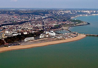
Folkestone and Hythe is a local government district in Kent, England. It lies in the south-east of the county, on the coast of the English Channel. The district was formed in 1974 and was originally named Shepway after one of the ancient lathes of Kent, which had covered a similar area. The district was renamed in 2018. The council is based in Folkestone, the district's largest town. The district also includes the towns of Hawkinge, Hythe, Lydd and New Romney, along with numerous villages and surrounding rural areas.

The A25 road is an east–west main road in the South-East of England. Its carries traffic east from Guildford, Surrey, eastward through Surrey and into mid-west Kent, to the town of Sevenoaks, and then on to Wrotham Heath where it connects with the A20.

The Borough of Ashford is a local government district with borough status in Kent, England. It is named after its largest town, Ashford, where the council is based. The borough also includes the town of Tenterden and an extensive surrounding rural area including numerous villages; with an area of 580 square kilometres (220 sq mi), it is the largest district in Kent. Parts of the borough lie within the designated Areas of Outstanding Natural Beauty of High Weald and the Kent Downs.

Ashford is a town in Spelthorne, in Surrey, England, including some areas within the London Borough of Hounslow. The town lies 14 mi (23 km) west of central London. Its name derives from a crossing point of the River Ash, a distributary of the River Colne. Historically part of Middlesex, the town has been part of Surrey since 1965. Ashford consists of relatively low density low- and medium-rise buildings, none of them being high rise. If excluding apartments most houses are semi-detached. In 2011 it had a population of 27,382.

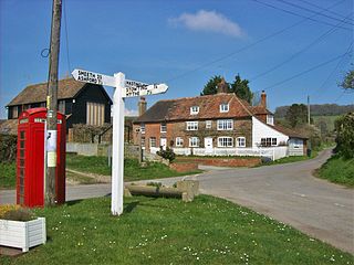
Charing is a village and civil parish in the Ashford district of Kent, in south-east England. It includes the settlements of Charing Heath and Westwell Leacon. It is located at the foot of the North Downs and reaches up to the escarpment. In 2011 the parish had a population of 2766.

Upper Halliford is a small village in the Borough of Spelthorne, Surrey, England approximately 24 km (15 mi) west of central London. It is part of the Shepperton post town and is in the Metropolitan Green Belt. The closest settlements are Shepperton, Charlton and Walton on Thames. St Andrew’s Baptist Church is in the southern part of the village and the settlement is in the ecclesiastical Parish of Sunbury on Thames. The conservation area surrounds the village green.

Bearsted is a village and civil parish with a railway station in mid-Kent, England, two miles (3.2 km) east of Maidstone town centre.

Stanwell is a village in the Spelthorne district, in Surrey, England. It is 16 miles (26 km) west of central London. A small corner of its land is used as industrial land for nearby Heathrow Airport. The rest of the village is made up of residential and recreational land. Historically part of the county of Middlesex, it has, like the rest of Spelthorne, been in Surrey since 1965. The village is to the south of the cargo-handling area of Heathrow Airport and to the east of the Staines Reservoirs. Stanwell is the northernmost settlement in Surrey, bordering Berkshire and Greater London.

Harrietsham is a rural and industrial village and civil parish in the Maidstone District of Kent, England. According to the United Kingdom Census 2001, it had a population of 1,504, increasing to 2,113 at the 2011 Census. The parish is in the North Downs, 7 miles (10 km) east of Maidstone; it includes the settlements of Marley, Pollhill and Fairbourne.
Brabourne is a village and civil parish in the Ashford district of Kent, England. The village centre is 4.5 miles (7.2 km) east of Ashford town centre.

Mersham is a mostly agricultural large village and civil parish near Ashford in Kent, England. The population of the civil parish includes the area of Cheesman's Green now known as Finberry.
Great Chart with Singleton is a civil parish in the Ashford district of Kent, England. The parish population is mostly concentrated in the ancient village of Great Chart and the modern Singleton housing development, both located in the eastern part of the parish, near the town of Ashford. Singleton accounts for about 80% population of the entire parish and is directly adjacent to Ashford. The village of Great Chart is located to the west of Singleton, about two miles (3.2 km) from the centre of Ashford. The remaining area of the parish is largely agricultural, with several farms. Chilmington Green is also included in the civil parish.
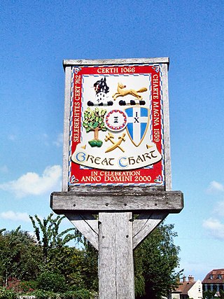
Great Chart is a village and former civil parish, now in the parish of Great Chart with Singleton, in the Ashford borough of Kent, England. The parish is split between the ancient village of Great Chart and the modern Singleton neighbourhood on the western outskirts of Ashford. The village centre of Great Chart is 2 miles (3.2 km) from the town centre. In 1961 the parish had a population of 969.

Hothfield is a village and civil parish in the Ashford Borough of Kent, England and is 3 miles north-west of Ashford on the A20. It is completely split in two by Hothfield Common.

Newington is a village and civil parish in the English county of Kent located 1 mile (1.6 km) north-west of Folkestone. It gives its name to Newington Parish Council, which has five councillors, and includes the hamlets of Arpinge and Beachborough. The village lies to the north of the M20 motorway and the A20 road; the Channel Tunnel complex is nearby.

Little Chart is a village and civil parish, situated 4 miles (6.4 km) north-west of Ashford in Kent, South East England. The parish lies south of the M20 motorway.

Westwell is a village and relatively elevated civil parish centred 4 miles (6 km) north of Ashford in Kent, England, in the Borough of Ashford.

Brabourne Lees is a village in the civil parish of Brabourne, within the Ashford borough of Kent, England. The village (centre) is just under 5 miles (8 km) east of Ashford town centre itself geographically. By road this is a journey of about 6 miles (10 km). In 2021 it had a population of 1480.

