
St Nicholas-at-Wade is both a village and a civil parish in the Thanet District of Kent, England. The parish had a recorded population of 782 at the 2001 Census, increasing to 852 at the 2011 census. The village of Sarre is part of the civil parish.

Charing is a village and civil parish in the Ashford District of Kent, in south-east England. It includes the settlements of Charing Heath and Westwell Leacon. It is located at the foot of the North Downs and reaches up to the escarpment.

Meopham is a large linear village and civil parish in the Borough of Gravesham in Kent, England, lying to the south of Gravesend. The parish covers 6.5 square miles (17 km2), and comprises two villages and two smaller settlements; it has a population of 6,427 increasing slightly to 6,722 at the 2011 census. Meopham village is sometimes described as the longest settlement in England although others such as Brinkworth, Wiltshire make the same claim. Meopham is one of the longest linear settlements in Europe, being 7 miles (11 km) in length.

Borough Green is an unclassified English urban community and a civil parish in the borough of Tonbridge and Malling in Kent, England. The central area is situated on the A25 road between Maidstone and Sevenoaks, with the M26 motorway running through it within a mile of the centre. The word ‘Borough’ relates to the fact that Borough Green was a developed suburban area of Wrotham village and the division spread in the 1980’s with the M26 motorway running through the centre.

Pluckley and Pluckley Thorne are two close clustered neighbourhoods in the Pluckley civil parish, in the Ashford district of Kent, England.
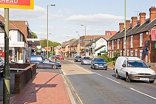
Chandler's Ford is a largely residential area and civil parish in the Borough of Eastleigh in Hampshire, England, with a population of 21,436 in the 2011 UK Census.

Chartham is a village and civil parish in the Canterbury district of Kent, England. It is situated on the Ashford side of the city, and is in the North Downs area of Outstanding Natural Beauty, 2.3 mi (4 km) south west of Canterbury, England. The Great Stour Way path passes through the village. A paper mill in the village has specialised in the production of tracing paper since 1938. There are numerous arable farms and orchards in the parish. The village has an unmanned station, Chartham, and a manned level crossing. It has an outlying locality sharing in many of the community resources, Chartham Hatch.

Addington is a village in the English county of Kent. It is close to the M20 motorway, and between the villages of Wrotham Heath and West Malling. In the Domesday Book of 1086 it is called Eddintune. The meaning of the village's name is "Æddi's estate". The village is notable for the long barrows, Neolithic chamber tombs. Its parish covers a little under 700 acres (2.8 km2), containing 291 houses. Addington Brook runs through the parish.

Aldington is a village and civil parish in the Ashford District of Kent, England. The village centre is eight miles (12 km) south-east of the town of Ashford. As with the village centre, set on a steep escarpment above agricultural Romney Marsh and the upper Stour is Aldington Knoll, which was used as a Roman burial barrow and later beacon, it has a panorama towards the English Channel and of low land such as Dungeness. At the 2011 Census the population included Bonnington.

Kennington is a suburb of Ashford and civil parish in Kent, England. It is about a mile northeast of the town centre and north of the M20 motorway, and contains the 12th-century church, St Mary's. The main A28 Canterbury Road and A2042 Faversham Road run through the village, and the A251 Trinity Road skirts the western edge. In recent years the village has expanded with the building of new housing estates in the Little Burton, Towers View and Conningbrook Park areas.

Mersham is a mostly agricultural large village and civil parish, three miles east of Willesborough and Ashford in Kent, England. The population of the civil parish includes the area of Cheesman's Green now known as Finberry.
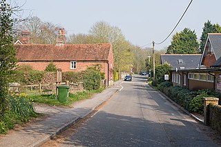
Compton and Shawford is a civil parish in the City of Winchester district, immediately southwest of the city, in Hampshire, England. Its main settlements are the villages of Compton and Shawford.

The Stour Valley Walk is a recreational walking route that follows the River Stour, through the Low Weald and Kent Downs, from its source at Lenham to its estuary at Pegwell Bay.

Egerton is a village and civil parish in the Ashford District of Kent, England. The village is on the Greensand Ridge 9 miles (14.4 km) north of Ashford and stretches three miles south into a lower plain towards the West Stour. The parish is a relatively scattered rural one; the settlement of Stonebridge Green, adjacent to Egerton village centre, is also in the parish.
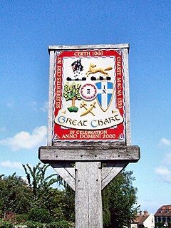
Great Chart is a village in the civil parish of Great Chart with Singleton in the Ashford Borough of Kent, England. The parish is split between the ancient village of Great Chart and the modern Singleton neighbourhood on the western outskirts of Ashford. The village centre of Great Chart is 2 miles (3.2 km) from the town centre. In 1961 the parish had a population of 969.

Preston or Preston-next-Wingham is a civil parish and village in valley of the Little Stour in the Dover District of Kent, England. The village is on the B2076 secondary road. The parish includes the hamlet of Elmstone. The main river through the area is a tributary of the River Stour. The suffix 'next-Wingham' distinguishes the area from Preston-next-Faversham and the Domesday Book chronicled Preston as 'Prestetune;

Ospringe is a village and area of Faversham in the English county of Kent. It is also the name of a civil parish, which since 1935 has not included the village of Ospringe.

Wickhambreaux is a small rural village in Kent, England. The village is just off the A257 Sandwich Road, four miles east of the city of Canterbury. Since Roman times the village has had connections to the Church and the Crown, including being owned by Joan of Kent in the 14th century. The 13th-century parish church of St Andrew stands around a medieval village green along with other historic buildings.

Fittleworth is a village and civil parish in the District of Chichester in West Sussex, England located seven kilometres (3 miles) west from Pulborough on the A283 road and three miles (5 km) south east from Petworth. The village has an Anglican church, a primary school and one pub, The Swan. It is within the ancient divisions of the Bury Hundred and the Rape of Arundel. The village is bounded south by the Rother Navigation.

Painters Forstal is a village in the Swale district of the English county of Kent. It is 2 miles (3.2 km) south-west of the town of Faversham and is part of the civil parish of Ospringe. It lies just south of the M2 motorway, and has developed almost completely since the 1950s.


