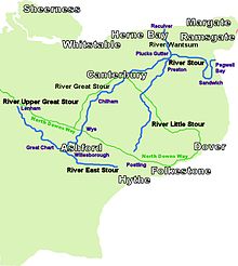
Stour Valley Walk

Last updated

The River Routes River Stour Map.jpg
The River Routes

The Stour Valley Walk is a recreational walking route that follows the River Stour, through the Low Weald and Kent Downs, from its source at Lenham to its estuary at Pegwell Bay.

Contents

Stour Valley Signs Stour Valley Logo.jpg
Stour Valley Signs

The walk passes through some of Kent's finest landscapes, most important nature sites and most historic, unspoilt villages. [1] The walk is signed with the logo of a heron, a bird occasionally seen in the area.

The 58 miles (93 km) [2] route is of interest for its landscape and history, and for its archaeological, historical and architectural features. Part of the Pilgrims' Way followed the river valley from Wye to Canterbury after the North Downs.

The walk passes through a varied landscape of downland, woodland, orchards, hop gardens and farmland; lakes, dykes and marshland; unspoilt villages and hamlets, and historic towns. [3]

It is possible to reach the walk from Maidstone via the 12 kilometre long Len Valley Walk.

The route

From Lenham across the countryside View from Lenham.JPG
From Lenham across the countryside

Lenham to Little chart

6+14 miles (10.1 km)grid reference TQ897522 to grid reference TQ950460

Walking south-east from Lenham, across the church yard and then immediately into the countryside, through agricultural fields, gaining a first sighting of a stream running to become part of the River. The route then traverses a pedestrian crossing of the railway, to Lenham Heath and then over High Speed 1 and the Motorway (M20) to Little Chart where the path joins the Greensand Way.
Little Chart Church Little Chart Church.jpg
Little Chart Church

Little Chart to Ashford

8+14 miles (13.3 km)grid reference TQ950460 to grid reference TR005425

The Stour Valley Walk separates from the Greensand Way at Hothfield Common and merges again at Godinton , heading south to Great Chart, where the Greensand Way continues south, to Kingsnorth and Hamstreet. Our walk follows the now larger upper reaches of the Great Stour eastwards to Singleton Lake and along the Ashford Green Corridor (Local Nature Reserve) into Ashford's centre.
The Ashford Green Corridor web site has a very useful map showing Singleton Lake and other green areas within Ashford and the route of this part of the walk. In this section of the walk common kingfishers, grass snakes, damselflies and possibly water voles can be seen. [5]

Ashford to Wye

5+12 miles (8.9 km)grid reference TR005425 to grid reference TR053467

The confluence of the East Stour and the Great Stour is at the old mill at the bottom of East Hill in Ashford, and the walk continues from here, heading east to Willesborough Lees and then north to Wye where the Stour Valley Walk crosses the North Downs Way's southerly section.

Wye to Chilham

8+14 miles (13.3 km)grid reference TR053467 to grid reference TR069537

There is a slight ascent as the route leaves Wye, rising from 35 m to 150 m, and some of the paths are narrow containing rabbit holes.
In this stage the Stour Valley Walk follows the path of the Great Stour river as it meanders through the countryside of East Kent. One of the most beautiful sections of this walk can be found between the villages of Wye and Chilham, passing through a rolling landscape with panoramic views. There are regular bus and train links to both Canterbury and Ashford from the start and finish points of this walk.
The Wye Crown Wye Crown.jpg
The Wye Crown
From the station at Wye walk up into the village crossing the river for the first time, and turn left into Church Street. From the church follow the route signs for the North Downs Way and Stour Valley Walk, pass through the college buildings crossing a road and then out into open farmland. Here the Stour Valley Walk and the North Downs Way separate, as the North Downs Way heads east, above the Wye Crown to Dover. Follow the path cutting diagonally left across the field towards woodland.
Once through the woodland the path dips into the valley offering views of the surrounding countryside and then continues through coppiced woodland to open meadow land and the village of Crundale. The path follows an unmade road branching off to the left across farmland leading into dense woodland, where it is lined with yew trees. The walk follows several sections of woodland, and as the route approaches Chilham, there are views of the castle.[ citation needed ] The path then branches to the left over a stile, this link path then takes walkers back down to the river to the Chilham mill.[ citation needed ]
For Chilham village square follow the road from the mill to the A28. The main square boasts timber framed houses, a 13th century church and the impressive castle gateway.
For the railway station turn right at the main road and continue for approximately 150 metres then turn left – the station should be clearly signed. [6]
The River in Canterbury city centre Canterbury - Klein-Venedig am Stour.jpg
The River in Canterbury city centre

Chilham to Canterbury

7+12 miles (12.1 km)grid reference TR069537 to grid reference TR147577

Leaving Chilham village, head east across the river to pick up the main Stour Valley Walk, passing the Neolithic long barrow, Julliberrie's Grave and then follow the route north-east to Shalmsford Street, and on towards Thanington Without and Canterbury.

Canterbury to Upstreet

8+12 miles (13.7 km)grid reference TR147577 to grid reference TR224629

Upstreet to Sandwich

10+12 miles (16.9 km)grid reference TR224629 to grid reference TR328583 At Upstreet the path joins the Saxon Shore Way heading towards Sandwich.

Sandwich to Pegwell Bay

3+12 miles (5.6 km)grid reference TR328583 to grid reference TR345623

See also

Related Research Articles

<span class="mw-page-title-main">River Stour, Kent</span> River in England

The River Stour(, rhymes with "flour") is a river in Kent, England that flows into the North Sea at Pegwell Bay. Above Plucks Gutter, where the Little Stour joins it, the river is normally known as the Great Stour. The upper section of the river, above its confluence with the East Stour at Ashford is sometimes known as the Upper Great Stour or West Stour. In the tidal lower reaches, the artificial Stonar Cut short cuts a large loop in the natural river.

<span class="mw-page-title-main">Wye, Kent</span> Human settlement in England

Wye is the smallest town in Britain, located in Kent, England, 5 miles (8.0 km) from Ashford and 12 miles (19 km) from Canterbury. It is the main settlement in the civil parish of Wye with Hinxhill. Hop varieties including Wye Challenger were bred at Wye College and named for the village.

<span class="mw-page-title-main">North Downs Way</span> Long-distance footpath in the south of England

The North Downs Way National Trail is a long-distance path in southern England, opened in 1978. It runs from Farnham to Dover, past Guildford, Dorking, Merstham, Otford and Rochester, along the Surrey Hills Area of Outstanding Natural Beauty (AONB) and Kent Downs AONB.

<span class="mw-page-title-main">A28 road</span> Trunk road in Kent and East Sussex

The A28 is a trunk road in the counties of Kent and East Sussex in south east England, connecting Margate, Canterbury, Ashford and Hastings.

<span class="mw-page-title-main">Pilgrims' Way</span> Historic walking route in England

The Pilgrims' Way is the historical route supposedly taken by pilgrims from Winchester in Hampshire, England, to the shrine of Thomas Becket at Canterbury in Kent. This name, of comparatively recent coinage, is applied to a pre-existing ancient trackway dated by archaeological finds to 600–450 BC, but probably in existence since the Stone Age. The prehistoric route followed the "natural causeway" east to west on the southern slopes of the North Downs.

<span class="mw-page-title-main">Rivers of Kent</span>

Four major rivers drain the county of Kent, England.

<span class="mw-page-title-main">Kent Downs</span> Area of Outstanding Natural Beauty in Kent, England

The Kent Downs is an Area of Outstanding Natural Beauty (AONB) in Kent, England. They are the eastern half of the North Downs and stretch from the London/Surrey borders to the White Cliffs of Dover, including a small section of the London Borough of Bromley. The AONB also includes the Greensand Ridge, a prominent sandstone escarpment which lies south of the chalk escarpment of the North Downs.

<span class="mw-page-title-main">Lenham</span> Human settlement in England

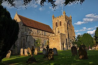
Lenham is a market village and civil parish in Kent situated on the southern edge of the North Downs, 9 miles (14 km) east of Maidstone. The picturesque square in the village has two public houses, a couple of restaurants, and a tea-room. Lenham has a population of 3,370 according to the 2011 Census.

Hastingleigh is a small civil parish centred on an escarpment of the Kent Downs.

<span class="mw-page-title-main">Greensand Way</span>

The Greensand Way is a long-distance path of 108 miles (174 km) in southeast England, from Haslemere in Surrey to Hamstreet in Kent. It follows the Greensand Ridge along the Surrey Hills and Chart Hills. The route is mostly rural, passing through woods, and alongside fruit orchards and hop farms in Kent and links with the Stour Valley Walk near Pluckley in Kent. The trail was opened on 15 June 1980 and is jointly managed by Surrey and Kent Councils who fully updated it in 2012.
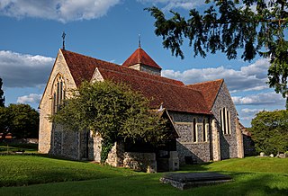
<span class="mw-page-title-main">Chilham</span> Human settlement in England

Chilham is a mostly agricultural village and parish in the English county of Kent with a clustered settlement, Chilham village centre, in the northeast, and a smaller linear settlement, Shottenden. Well-preserved roads and mostly residential listed buildings in its centre have led to its use as a location in television and film.

The Vanguard Way is a long-distance walk of 66.2 mi (106.5 km) from East Croydon station in outer London, travelling from the north, to Newhaven, on the south coast of England. It passes through the counties of Surrey, Kent and East Sussex, between Croydon and Newhaven, East Sussex. It connects the London suburbs to the south coast, via the North Downs, Ashdown Forest, South Downs National Park and the Cuckmere valley.

<span class="mw-page-title-main">Ashford–Ramsgate line</span>

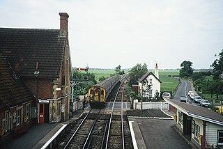
The Ashford–Ramsgate line is a railway that runs through Kent from Ashford to Ramsgate via Canterbury West. Its route mostly follows the course of the River Great Stour.

<span class="mw-page-title-main">Saxon Shore Way</span> Long-distance footpath in England

The Saxon Shore Way is a long-distance footpath in England. It starts at Gravesend, Kent, and traces the coast of South-East England as it was in Roman times as far as Hastings, East Sussex, 163 miles (262 km) in total. This means that around Romney Marsh the route runs significantly inland from the modern coastline.

Lenham Heath is a hamlet in Kent situated on the southern edge of the North Downs, halfway between Maidstone and Ashford. grid reference TQ910500.

<span class="mw-page-title-main">Godmersham</span> Human settlement in England

Godmersham is a village and civil parish in the Ashford District of Kent, England. The village straddles the Great Stour river where it cuts through the North Downs and its land is approximately one third woodland, all in the far east and west on the escarpment of the North Downs. It is six miles north-east of Ashford on the A28 road midway between Ashford and Canterbury in an Area of Outstanding Natural Beauty with the North Downs Way and Pilgrims' Way traversing the parish.

The following is a list of recreational walks in Kent, England.

<span class="mw-page-title-main">Vale of Holmesdale</span>

Holmesdale, also known as the Vale of Holmesdale, is a valley in South-East England that falls between the hill ranges of the North Downs and the Greensand Ridge of the Weald, in the counties of Kent and Surrey. It stretches from Folkestone on the Kent coast, through Ashford, Harrietsham, Maidstone, Riverhead/Sevenoaks, Westerham, Oxted, Godstone, Redhill, Reigate, Dorking, Gomshall, and Guildford – west of which it is also called by the local name of "Puttenham Vale" – as it continues through the village of Puttenham, to the market town of Farnham.

<span class="mw-page-title-main">Stour watermills</span>

The River Stour has been used for centuries as a source of power. Many different processes were performed by the use of water power:- Corn milling, fulling, paper making and electricity generation. Many of the mills survive today as house conversions, with two of them still working commercially.

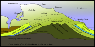
The geology of Kent in southeast England largely consists of a succession of northward dipping late Mesozoic and Cenozoic sedimentary rocks overlain by a suite of unconsolidated deposits of more recent origin.

References

  1. Kentish Stour Countryside Project Archived 17 May 2006 at the Wayback Machine
  2. "Stour Valley walk". Explore Kent. Retrieved 30 September 2022.
  3. Kent County Council
  4. Nature Grid Archived 7 January 2004 at the Wayback Machine
  5. "Ashford Green Corridor". Archived from the original on 11 February 2006. Retrieved 14 March 2006.
  6. BBC Discover Kent

Coordinates: 51°12′42″N0°58′31″E / 51.21167°N 0.97528°E / 51.21167; 0.97528