
The Borough of Tunbridge Wells is a local government district with borough status in Kent, England. It takes its name from its main town, Royal Tunbridge Wells. The borough also contains the towns of Paddock Wood and Southborough, along with numerous villages and surrounding rural areas. Large parts of the borough fall within the High Weald Area of Outstanding Natural Beauty.

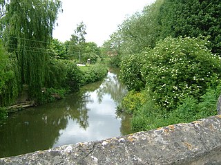
Four major rivers drain the county of Kent, England.

The Spa Valley Railway (SVR) is a standard gauge heritage railway in the United Kingdom that runs from Tunbridge Wells West railway station in Royal Tunbridge Wells to High Rocks, Groombridge, and Eridge, where it links with the Oxted Line.

The Oxted line is a railway line in southern England. It runs from the Brighton Main Line at South Croydon in Greater London to Hurst Green Junction in Surrey, where its two branches diverge. The western branch continues via Lingfield to East Grinstead in West Sussex, whereas the eastern branch runs via Edenbridge Town in Kent to Uckfield in East Sussex. The line is named after the town of Oxted in Surrey and also serves parts of the London Borough of Croydon. The 18-mile-26-chain (29.5 km) South Croydon–East Grinstead section is electrified using the 750 V DC third-rail system and is double track throughout. The unelectrified Hurst Green Junction–Uckfield section is 24 mi 53 ch (39.7 km) in length and, south of Hever, is mostly single track.

Canterbury East railway station is on the Dover branch of the Chatham Main Line in England, and is one of two stations serving the city of Canterbury, Kent.

Headcorn railway station is on the South Eastern Main Line in England, serving the village of Headcorn, Kent. It is 45 miles 20 chains (72.8 km) down the line from London Charing Cross. The station and all trains that serve the station are operated by Southeastern.

Hurst Green railway station is on the Oxted line in southern England and serves the Hurst Green neighbourhood of Oxted in Surrey. It is 21 miles 20 chains from London Bridge. The station is managed by Southern.

Groombridge is a village of about 1,600 people. It straddles the border between Kent and East Sussex, in England. The nearest large town is Royal Tunbridge Wells, about 4.5 miles (7.2 km) away by road.
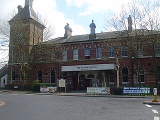
Tunbridge Wells West is a railway station located in Royal Tunbridge Wells, Kent, England. It is one of two railway stations in Tunbridge Wells constructed by rival companies. The other, Tunbridge Wells Central was opened in 1845 by the South Eastern Railway (SER). Tunbridge Wells West was closed to mainline passenger services in 1985. A new station on part of the site has been opened as a heritage railway line opened in 1996. It stands next to the original engine shed which has been restored to use. The line is called the Spa Valley Railway.
Stone Cross is a hamlet in the civil parish of Speldhurst, in the Tunbridge Wells district, in the county of Kent, England. It is on the A264 road east of Ashurst. There are few houses and no shops. Burrswood, a building designed by Decimus Burton is located between the hamlet and Groombridge it in commercial use by a Christian charity.

Teston Crossing Halt was situated on what is now the Medway Valley Line, south of Maidstone, in Kent, and served Teston and West Farleigh. It opened on 1 September 1909 and closed on 2 November 1959.

Withyham was a railway station on the Three Bridges to Tunbridge Wells Central Line which closed in 1967, a casualty of the Beeching Axe. The station opened on 1 October 1866 and the buildings were designed by Charles Henry Driver. The station building survived the closure and is now a private residence named the "Old Withyham Station"; much of the trackbed as far as Groombridge and Three Bridges are part of the Worth Way and Forest Way cyclepath/footpaths.
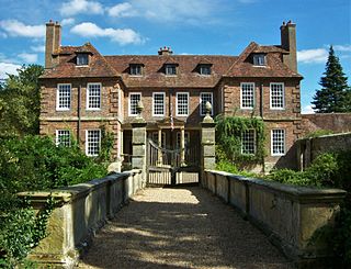
Groombridge Place is a moated manor house in the village of Groombridge near Tunbridge Wells, Kent, England. It has become a tourist attraction, noted for its formal gardens and vineyards. The manor house has an associated dower house.
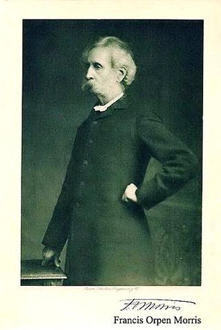
Francis Orpen Morris was an Anglo-Irish clergyman, notable as "parson-naturalist" and as the author of many children's books and books on natural history and heritage buildings. He was a pioneer of the movement to protect birds from the plume trade and was a co-founder of the Plumage League. He died on 10 February 1893 and was buried at Nunburnholme, East Riding of Yorkshire, England.

The River Bourne rises in the parish of Ightham, Kent and flows in a generally south easterly direction through the parishes of Borough Green, Platt, Plaxtol, West Peckham, Hadlow, and East Peckham where it joins the River Medway. In the 18th century the river was known as the Busty or Buster, the Shode or Sheet, but is not known by these names nowadays. A bourne is a type of stream, while shode means a branch of a river.
The Wateringbury stream is a tributary of the River Medway in Kent, England. It rises at Swanton, West Peckham parish, flows south east towards Mereworth and then flows in a generally easterly direction to join the River Medway at Wateringbury. It is some four miles (6 km) long and powered a number of watermills.
The River Beult is a tributary of the River Medway in South East England.

High Rocks is a 3.2-hectare (7.9-acre) geological Site of Special Scientific Interest west of Tunbridge Wells in East Sussex and Kent. It is a Geological Conservation Review site.
Philip Packer FRS was an English barrister and architect. He was a courtier to Charles II, and friend to Christopher Wren.

Canterbury Parkway railway station is a proposed interchange between the Ashford–Ramsgate line and the Chatham Main Line near Canterbury, Kent.
