Hawley, Kent

Last updated

Hawley
Kent UK location map.svg
Red pog.svg
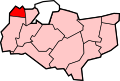
Hawley
Location within Kent
District
Shire county
Region
Country England
Sovereign state United Kingdom
Post town Dartford
Postcode district DA2
Police Kent
Fire Kent
Ambulance South East Coast
UK Parliament
List of places
UK
England
Kent
51°25′13″N0°13′21″E / 51.4204°N 0.2224°E / 51.4204; 0.2224

Hawley is a village in the civil parish of Sutton-at-Hone and Hawley in the Borough of Dartford, Kent, England. It is located 3 miles south of Dartford and 3.8 miles north east of Swanley.

Contents

Transport

Railway

The nearest National Rail stations to Hawley are Farningham Road, located 2.2 miles away and Dartford, located 3 miles away.

Buses

Hawley is served by the Arriva Kent Thameside route 414, which connects it with Dartford.

Related Research Articles

<span class="mw-page-title-main">Dartford Crossing</span> Tunnel and bridge between Kent and Essex, UK

The Dartford-Thurrock River Crossing, commonly known as the Dartford Crossing and until 1991 the Dartford Tunnel, is a major road crossing of the River Thames in England, carrying the A282 road between Dartford in Kent in the south and Thurrock in Essex in the north.

<span class="mw-page-title-main">Borough of Dartford</span> Borough & Non-metropolitan district in England

The Borough of Dartford is a local government district in the north-west of the county of Kent, England. Its council is based in the town of Dartford. It is part of the contiguous London urban area. It borders the borough of Gravesham to the east, Sevenoaks District to the south, the London Borough of Bexley to the west, and the Thurrock unitary authority in Essex to the north, across the River Thames. The borough was formed on 1 April 1974 by the merger of the Municipal Borough of Dartford, the Swanscombe Urban District, and part of the Dartford Rural District. According to the 2011 Census, its population was 97,365.

Stone is a village in the Borough of Dartford in Kent, England. It is located 2.5 miles east of Dartford.

<span class="mw-page-title-main">Swanley</span> Human settlement in England

Swanley is a town and civil parish in the Sevenoaks District of Kent, England, 16 miles (26 km) southeast of central London, adjacent to the Greater London boundary and within the M25 motorway periphery. The population at the 2021 census was 17,826.

<span class="mw-page-title-main">Sutton-at-Hone and Hawley</span>

Sutton-at-Hone and Hawley is a civil parish within the Borough of Dartford in Kent, England. It lies to the south of the urban part of the Borough, and consists of the two settlements named, both to the west of the River Darent, one of the parish boundaries. The M25 motorway divides them. It has a population of 4,133, increasing to 4,230 at the 2011 Census.

Southfleet is a small village and civil parish in the borough of Dartford in Kent, England. The village is located three miles southwest of Gravesend, while the parish includes within its boundaries the hamlets of Betsham and Westwood.

<span class="mw-page-title-main">Dartford Loop Line</span> Railway line in the UK

The Dartford Loop Line is one of three lines linking London with Dartford in Kent, England. It lies to the south of the other two: the North Kent Line and the Bexleyheath Line.

<span class="mw-page-title-main">Rainham railway station (Kent)</span> Railway station in Kent, England

Rainham railway station is on the Chatham Main Line in South East England, serving the town of Rainham, Kent. It is 38 miles 74 chains (62.6 km) down the line from London Victoria and is situated between Gillingham and Newington.

<span class="mw-page-title-main">Wilmington, Kent</span> Human settlement in England

Wilmington is a village and civil parish in the Borough of Dartford in Kent, England. It is located 2.7 miles south of Dartford, 3.5 miles north of Swanley and 4.3 miles south east of Bexleyheath, adjacent to the Kent border with Greater London.

<span class="mw-page-title-main">Ebbsfleet International railway station</span> Railway station in Kent, England

Ebbsfleet International railway station is in Ebbsfleet Valley, Kent, 10 miles east of London, England, near Dartford and the Bluewater shopping centre to the west and Gravesend to the east. The station, part of the Thames Gateway urban regeneration project, is on the High Speed 1 rail line, 400 metres south-west of Northfleet railway station, off the A2 trunk road, 5 mi (8.0 km) from its junction with the M25 motorway. It served as a primary park-and-rail service for the London 2012 Olympics.

<span class="mw-page-title-main">Bean, Kent</span> Human settlement in England

Bean is a village and civil parish in the Borough of Dartford, Kent, England. It is located 4.4 miles south east of Dartford and 5.4 miles south west of Gravesend.

<span class="mw-page-title-main">Hextable</span> Human settlement in England

Hextable is a village and civil parish in the Sevenoaks District of Kent, England. It lies 2 miles (3.2 km) north of Swanley and 4 miles (6.4 km) south of Dartford.

<span class="mw-page-title-main">Dartford F.C.</span> Association football club in Dartford, England

Dartford Football Club is a semi-professional association football club based in Dartford, Kent, England. As of the 2022–23 season, the club participates in the National League South, the sixth tier of English football.

Dartford Borough Council is the local authority for the Borough of Dartford in Kent, England. The council is elected every four years.

<span class="mw-page-title-main">Joyden's Wood</span>

Joyden's Wood is an area of ancient woodland that straddles the border between the London Borough of Bexley in South East London and the Borough of Dartford in Kent, England. It is located 2.7 miles (4.3 km) north west of Swanley, 3.3 miles (5.3 km) south east of Bexleyheath and 3.6 miles (5.8 km) south west of Dartford. It is one of over 1,000 woodlands in the United Kingdom looked after by the Woodland Trust. The first records of a wood on this site go back to the year 1600. It is also the name of a housing estate to the east of the woodland itself.

<span class="mw-page-title-main">Darenth</span> Human settlement in England

Darenth is a village and civil parish in the Borough of Dartford, Kent, England. It is located 3.4 miles south east of Dartford and 4.6 miles north east of Swanley.

<span class="mw-page-title-main">Swanley Village</span> Human settlement in England

Swanley Village is a village in the Sevenoaks District of Kent, England. It is located 1 mile north east of Swanley & 4.7 miles south west of Dartford.

Horton Kirby is a village in the Sevenoaks District of Kent, England. It is located 3.9 miles east of Swanley & 4.9 miles south of Dartford. Together with the nearby village of South Darenth, it forms the Horton Kirby and South Darenth civil parish.

<span class="mw-page-title-main">South Darenth</span> Human settlement in England

South Darenth is a village in the civil parish of Horton Kirby and South Darenth in the Sevenoaks District of Kent, England. It is located 4.2 miles east of Swanley & 4.4 miles south of Dartford.

<span class="mw-page-title-main">Sutton-at-Hone</span> Human settlement in England

Sutton-at-Hone is a village in the civil parish of Sutton-at-Hone and Hawley in the Borough of Dartford in Kent, England. It is located 3.5 miles south of Dartford & 3.6 miles north east of Swanley.

References