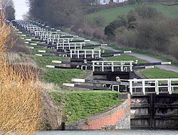
The Kennet and Avon Canal is a canal in southern England. The name may refer to either the route of the original Kennet and Avon Canal Company, which linked the River Kennet at Newbury to the River Avon at Bath, or to the entire navigation between the River Thames at Reading and the Floating Harbour at Bristol, including the earlier improved river navigations of the River Kennet between Reading and Newbury and the River Avon between Bath and Bristol. [1]
The River Kennet was made navigable to Newbury in 1723, and the River Avon to Bath in 1727. The Kennet and Avon Canal between Newbury and Bath was built between 1794 and 1810 by John Rennie, to convey commercial barges carrying a variety of cargoes, [2] and is 57 miles (92 km) long. The two river navigations and the canal total 87 miles (140 km) in length. [1] The section from Bristol to Bath is the course of the River Avon, which flows through a wide valley and has been made navigable by a series of locks and weirs. In the later 19th century and early 20th century the canal fell into disuse following competition from the Great Western Railway, who owned the canal. Between 1970 and 1990 the canal was restored, [3] largely by volunteers, and today is a popular heritage tourism destination, for boating, canoeing, fishing, walking and cycling. [4] It is also important for wildlife conservation.
There are 105 locks on the Kennet and Avon Canal from Bristol to the River Thames, including six on the navigable section of the River Avon from Bristol to Bath and nine on the navigable section of the River Kennet to its confluence with the Thames near Reading. The remaining 90 locks lie along the 57 miles (92 km) of canal. [1] In Bath the canal separates from the river but follows its valley as far as Bradford on Avon. The ornate Bath Locks lead to a stretch through Limpley Stoke valley with few locks. The flight of locks at Devizes, including the Caen Hill Locks, raises the canal to its longest pound, which then ascends the four Wootton Rivers locks to the short summit pound which includes the Bruce Tunnel. Pumping stations are used to supply the canal with water. The canal continues through the rural landscape of Wiltshire and Berkshire before joining the River Kennet at Newbury and becoming a navigable river to Reading, where it flows into the River Thames.
The following list numbers the locks from the River Avon in Bristol to the River Thames. It includes one lock that has been removed (98, Ufton Lock [5] ) and two that have been combined to form a single deep lock (8 and 9, now Bath Deep Lock). [6] [7] Travelling from Bristol to Reading, locks 1 to 54 are uphill, and locks 55 to 107 are downhill.
Lock number [D] | Lock name | Grid ref [C] | Listed building grade [F] | Rise / fall imperial (metres) |
---|---|---|---|---|
1 | Hanham Lock [A] | ST646700 | II [8] | ? |
2 | Keynsham Lock [A] | ST658690 | 6 feet 10 inches (2.08 m) [9] | |
3 | Swineford Lock [A] | ST691689 | 4 feet 4 inches (1.32 m) [10] | |
4 | Saltford Lock [A] | ST692679 | 3 feet 10 inches (1.17 m) [11] | |
5 | Kelston Lock [A] | ST688669 | 3 feet 1 inch (0.94 m) [12] | |
6 | Weston Lock [A] | ST725648 | 9 feet 3 inches (2.82 m) [13] | |
7 | Bath Bottom Lock | ST756643 | II [14] | 9 feet 3 inches (2.82 m) [15] |
8/9 | Bath Deep Lock | ST756643 | II [6] | 19 feet 5 inches (5.92 m) [7] |
10 | Wash House Lock | ST756643 | II [16] | 8 feet 6 inches (2.59 m) [17] |
11 | Abbey View Lock | ST756643 | II [18] | 9 feet 0 inches (2.74 m) [19] |
12 | Pulteney Lock | ST756643 | II [18] | 9 feet 5 inches (2.87 m) [20] |
13 | Bath Top Lock | ST756643 | II [21] | 9 feet 0 inches (2.74 m) [22] |
14 | Bradford Lock | ST825602 | 10 feet 3 inches (3.12 m) [23] | |
15 | Buckley's Lock | ST900609 | 8 feet 0 inches (2.44 m) [24] | |
16 | Barrett's Lock | ST900609 | 7 feet 10 inches (2.39 m) [25] | |
17–21 | Seend Locks | ST933613 | 38 feet 4 inches (11.68 m) [26] | |
22–50 | Caen Hill Locks | ST978614 | II [27] | 237 feet 0 inches (72.24 m) [26] |
51 | Wootton Rivers Lock | SU198629 | II [28] | 8 feet 0 inches (2.44 m) [26] |
52 | Heathy Close Lock | SU201631 | 8 feet 1 inch (2.46 m) [26] | |
53 | Brimslade Lock | SU209634 | II [29] | 8 feet 0 inches (2.44 m) [26] |
54 | Wootton Top Lock | SU212634 | 8 feet 0 inches (2.44 m) [26] | |
Summit of the canal | ||||
55–63 | Crofton Locks | SU254622 | II [30] [31] [32] | 61 feet 0 inches (18.59 m) [26] |
64 | Bedwyn Church Lock | SU278641 | II [33] | 7 feet 11 inches (2.41 m) [26] |
65 | Burnt Mill Lock | SU283649 | 7 feet 9 inches (2.36 m) [26] | |
66 | Potter's Lock | SU288654 | 7 feet 6 inches (2.29 m) [26] | |
67 | Little Bedwyn Lock | SU290659 | 6 feet 7 inches (2.01 m) [26] | |
68 | Oakhill Down Lock | SU299671 | II [34] | 5 feet 11 inches (1.80 m) [26] |
69 | Froxfield Middle Lock | SU301674 | 6 feet 11 inches (2.11 m) [26] | |
70 | Froxfield Bottom Lock | SU303676 | 7 feet 0 inches (2.13 m) [26] | |
71 | Picketfield Lock | SU315680 | 7 feet 0 inches (2.13 m) [26] | |
72 | Cobbler's Lock | SU321684 | 8 feet 3 inches (2.51 m) [26] | |
73 | Hungerford Marsh Lock | SU326685 | 8 feet 1 inch (2.46 m) [26] | |
74 | Hungerford Lock | SU336687 | 8 feet 0 inches (2.44 m) [26] | |
75 | Dun Mill Lock | SU352683 | II [35] | 5 feet 8 inches (1.73 m) [26] |
76 | Wire Lock | SU363681 | II [36] | 6 feet 10 inches (2.08 m) [37] |
77 | Brunsden Lock | SU372676 | II [38] | 4 feet 11 inches (1.50 m) [26] |
78 | Kintbury Lock | SU386671 | 5 feet 9 inches (1.75 m) [26] | |
79 | Dreweatt's Lock | SU411673 | II [39] | 5 feet 9 inches (1.75 m) [26] |
80 | Copse Lock | SU416670 | 6 feet 0 inches (1.83 m) [26] | |
81 | Hamstead Lock | SU424671 | II [40] | 6 feet 5 inches (1.96 m) [26] |
82 | Benham Lock | SU438665 | 6 feet 3 inches (1.91 m) [26] | |
83 | Higg's Lock | SU447667 | 5 feet 10 inches (1.78 m) [26] | |
84 | Guyer's Lock | SU453669 | II [41] | 7 feet 0 inches (2.13 m) [26] |
85 | Newbury Lock | SU470671 | II [42] | 3 feet 6 inches (1.07 m) [26] |
86 | Greenham Lock [B] | SU480673 | 8 feet 11 inches (2.72 m) [26] | |
87 | Ham Lock [B] | SU487672 | 4 feet 2 inches (1.27 m) [26] | |
88 | Bull's Lock [B] | SU499667 | 5 feet 9 inches (1.75 m) [26] | |
89 | Widmead Lock [B] | SU508663 | 3 feet 7 inches (1.09 m) [26] | |
90 | Monkey Marsh Lock [B] | SU522662 | 8 feet 8 inches (2.64 m) [26] | |
91 | Colthrop Lock [B] | SU538663 | 7 feet 7 inches (2.31 m) [26] | |
92 | Midgham Lock [B] | SU548662 | 7 feet 7 inches (2.31 m) [26] | |
93 | Heale's Lock [B] | SU562663 | 8 feet 11 inches (2.72 m) [26] | |
94 | Woolhampton Lock [B] | SU571665 | 8 feet 11 inches (2.72 m) [26] | |
95 | Aldermaston Lock [B] | SU601671 | II [43] | 8 feet 11 inches (2.72 m) [26] |
96 | Padworth Lock [B] | SU606672 | 5 feet 1 inch (1.55 m) [26] | |
97 | Towney Lock [B] | SU610680 | 9 feet 8 inches (2.95 m) [26] | |
98 | Site of Ufton Lock (ungated) [B] [G] | SU617686 | ||
99 | Tyle Mill Lock [B] | SU626691 | 6 feet 4 inches (1.93 m) [26] | |
100 | Sulhamstead Lock [B] | SU637698 | 4 feet 1 inch (1.24 m) [26] | |
101 | Sheffield Lock [B] | SU648706 | II* [44] [E] | 2 feet 2 inches (0.66 m) [26] |
102 | Garston Lock [B] | SU655707 | II* [45] | 7 feet 7 inches (2.31 m) [26] |
103 | Burghfield Lock [B] | SU674709 | 7 feet 0 inches (2.13 m) [26] | |
104 | Southcote Lock [B] | SU693712 | 5 feet 3 inches (1.60 m) [26] | |
105 | Fobney Lock [B] | SU705710 | 7 feet 8 inches (2.34 m) [26] | |
106 | County Lock [B] | SU713729 | 1 foot 2 inches (0.36 m) [26] | |
107 | Blake's Lock [H] | SU727735 | 3 feet 6 inches (1.07 m) [26] |
The River Avon is a river in the southwest of England. To distinguish it from a number of other rivers of the same name, it is often called the Bristol Avon. The name 'Avon' is a cognate of the Welsh word afon, meaning 'river'.
The Kennet and Avon Canal is a waterway in southern England with an overall length of 87 miles (140 km), made up of two lengths of navigable river linked by a canal. The name is used to refer to the entire length of the navigation rather than solely to the central canal section. From Bristol to Bath the waterway follows the natural course of the River Avon before the canal links it to the River Kennet at Newbury, and from there to Reading on the River Thames. In all, the waterway incorporates 105 locks.
The Kennet is a tributary of the River Thames in Southern England. Most of the river is straddled by the North Wessex Downs AONB. The lower reaches have been made navigable as the Kennet Navigation, which – together with the Avon Navigation, the Kennet and Avon Canal and the Thames – links the cities of Bristol and London.
Bristol Harbour is the harbour in the city of Bristol, England. The harbour covers an area of 70 acres. It is the former natural tidal river Avon through the city but was made into its current form in 1809 when the tide was prevented from going out permanently. A tidal by-pass was dug for 2 miles through the fields of Bedminster for the river, known as the "River Avon New Cut", "New Cut", or simply "The Cut". It is often called the Floating Harbour as the water level remains constant and it is not affected by the state of the tide on the river in the Avon Gorge, The New Cut or the natural river southeast of Temple Meads to its source.
Blake's Lock is a lock situated on the River Kennet in Reading, Berkshire, England. It is on the short reach of the River Kennet which is administered as if it were part of the River Thames and is hence owned and managed by the Environment Agency.
Claverton Pumping Station in the village of Claverton, in the English county of Somerset, pumps water from the River Avon to the Kennet and Avon Canal using power from the flow of the river. It is a Grade I listed building, having been upgraded from Grade II in 2019.
Hanham Lock is a canal lock situated on the River Avon, at the village of Hanham near Bristol, England.
Keynsham Lock is a canal lock situated on the River Avon at Keynsham, England.
Swineford Lock is a canal lock situated on the River Avon, at the village of Swineford, England.
Saltford Lock is a canal lock situated on the River Avon, at the village of Saltford, between Bristol and Bath, England.
Kelston Lock is a canal lock situated on the River Avon, between the villages of Kelston and Saltford, between Bristol and Bath, England.
Weston Lock is a canal lock situated on the River Avon, on the western outskirts of Bath, England, in what now forms the Newbridge suburb of Bath.
Garston Lock is a lock on the Kennet and Avon Canal. It is near the M4 motorway and near Reading, England.
Sheffield Lock, at grid reference SU648706, is a lock on the Kennet and Avon Canal, in the civil parish of Burghfield in the English county of Berkshire. It is also sometimes known as Shenfield Lock.
Oakhill Down Lock is a lock on the Kennet and Avon Canal, at Froxfield, Wiltshire, England, between Newbury Bridge and Pewsey Wharf.
Newbury Lock is a lock on the Kennet and Avon Canal in the town centre of Newbury, in the English county of Berkshire. It has a rise/fall of 3 ft 6 in, and is situated just upstream of Newbury Bridge.
Monkey Marsh Lock is a lock on the Kennet and Avon Canal, at Thatcham, Berkshire, England.
Woolhampton Lock is a lock on the Kennet and Avon Canal, in the village of Woolhampton in the English county of Berkshire. The lock has a rise/fall of 8 feet 11 inches (2.72 m) and is administered by the Canal and River Trust.
Caen Hill Locks are a flight of 29 locks on the Kennet and Avon Canal, between Rowde and Devizes in Wiltshire, England.
John Hore was an English engineer, best known for making the River Kennet and River Avon navigable. Hore was one of the earliest English canal engineers, and Sir Alec Skempton wrote that he was "in the first rank among the navigation engineers". The Hutchinson Chronology of World History described his work on the Kennet navigation as "[setting] a new standard for inland waterways, and is an important forerunner of the canals of the Industrial Revolution".