
The River Avon is a river in the south west of England. To distinguish it from a number of other rivers of the same name, it is often called the Bristol Avon. The name 'Avon' is a cognate of the Welsh word afon, meaning 'river'.

The Kennet and Avon Canal is a waterway in southern England with an overall length of 87 miles (140 km), made up of two lengths of navigable river linked by a canal. The name is used to refer to the entire length of the navigation rather than solely to the central canal section. From Bristol to Bath the waterway follows the natural course of the River Avon before the canal links it to the River Kennet at Newbury, and from there to Reading on the River Thames. In all, the waterway incorporates 105 locks.
The Dorset and Somerset Canal was a proposed canal in southwestern England. The main line was intended to link Poole, Dorset with the Kennet and Avon Canal near Bradford on Avon, Wiltshire. A branch was to go from the main line at Frome to the southern reaches of the Somerset coalfield at Nettlebridge. Construction of the branch started in 1786, using boat lifts rather than locks to cope with changes of level, but the company ran out of money and the canal was abandoned in 1803, never to be completed.

Bradford-on-Avon is a town and civil parish in west Wiltshire, England, near the border with Somerset, with a population of 9,402 at the 2011 census. The town's canal, historic buildings, shops, pubs and restaurants make it popular with tourists.

Claverton Pumping Station in the village of Claverton, in the English county of Somerset, pumps water from the River Avon to the Kennet and Avon Canal using power from the flow of the River Avon. It is a Grade I listed building, having been upgraded from Grade II in 2019.

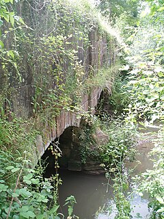
The Somerset Coal Canal was a narrow canal in England, built around 1800. Its route began in basins at Paulton and Timsbury, ran to nearby Camerton, over two aqueducts at Dunkerton, through a tunnel at Combe Hay, then via Midford and Monkton Combe to Limpley Stoke where it joined the Kennet and Avon Canal. This link gave the Somerset coalfield access east toward London. The longest arm was 10.6 miles (17.1 km) long with 23 locks. From Midford an arm also ran via Writhlington to Radstock, with a tunnel at Wellow.
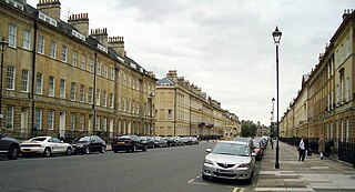
Bath Stone is an oolitic limestone comprising granular fragments of calcium carbonate. Originally obtained from the Combe Down and Bathampton Down Mines under Combe Down, Somerset, England, its warm, honey colouring gives the World Heritage City of Bath, England, its distinctive appearance. An important feature of Bath Stone is that it is a 'freestone', so-called because it can be sawn or 'squared up' in any direction, unlike other rocks such as slate, which forms distinct layers.
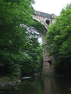
Marple Aqueduct at Marple, Greater Manchester, in north-west England was built to carry the lower level of the Peak Forest Canal across the River Goyt.

Navigable aqueducts are bridge structures that carry navigable waterway canals over other rivers, valleys, railways or roads. They are primarily distinguished by their size, carrying a larger cross-section of water than most water-supply aqueducts. Roman aqueducts were used to transport water and were created in Ancient Rome. The 662-metre (2,172 ft) long steel Briare aqueduct carrying the Canal latéral à la Loire over the River Loire was built in 1896. It was ranked as the longest navigable aqueduct in the world for more than a century, until the Magdeburg Water Bridge in Germany took the title in the early 21st century.

Avoncliff is a small village in west Wiltshire, England, in the north of Westwood parish about 1.5 miles (2.4 km) southwest of Bradford-on-Avon.

Limpley Stoke is a village and civil parish in Wiltshire, England. It lies in the Avon valley between Bath and Freshford, and is both above and below the A36 road.
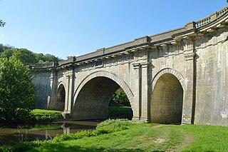
Dundas Aqueduct carries the Kennet and Avon Canal over the River Avon and the Wessex Main Line railway from Bath to Westbury. The aqueduct is near Monkton Combe, Somerset, and is about 2+1⁄2 miles (4 km) southeast of the city of Bath.

Garston Lock is a lock on the Kennet and Avon Canal. It is near the M4 motorway and near Reading, England.
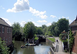
Newbury Lock is a lock on the Kennet and Avon Canal in the town centre of Newbury, in the English county of Berkshire. It has a rise/fall of 3 ft 6 in, and is situated just upstream of Newbury Bridge.
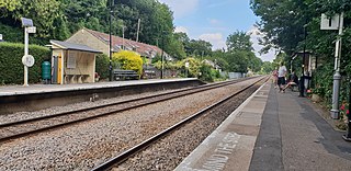
Avoncliff railway station serves the hamlet of Avoncliff in Wiltshire, England, together with the nearby villages of Westwood and Winsley, and Turleigh hamlet. It is next to the Kennet and Avon Canal and almost adjacent to the Avoncliff Aqueduct, so it is popular with walkers and cyclists who wish to travel along the canal path or the picturesque walks around the station.

Semington Aqueduct is an aqueduct at Semington, Wiltshire, England, UK. It carries the Kennet and Avon Canal over the Semington Brook.

Conkwell is a hamlet in Winsley parish, Wiltshire, England, near the county border with North East Somerset. It is about 2.3 miles (3.7 km) west of Bradford-on-Avon and 3 miles (5 km) southeast of the city of Bath. The settlement was established to house the workers in the local stone quarries. The southern side is in Winsley, but the northern is in the Somerset parish of Bathford.

Winsley is a large village and civil parish about 2 miles (3 km) west of Bradford on Avon in Wiltshire, England.

Westwood is a large village and a civil parish in west Wiltshire, England. The village is about 1.4 miles (2.3 km) southwest of the town of Bradford-on-Avon.
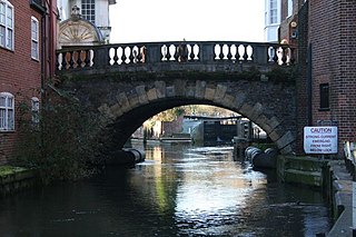
Newbury Bridge, also known as Kennet Bridge or Town Bridge, is a bridge across the River Kennet in the town centre of Newbury in the English county of Berkshire. The bridge carries Bridge Street, which links Northbrook Street, to the north of the river, with Bartholomew Street, to the south. The river channel under the bridge is also used by boats navigating the Kennet and Avon Canal. The current bridge was built between 1769 and 1772 and has three arches, although the two outer arches are now hidden by flanking buildings. It is a Grade II* listed structure.


