Bradford-on-Avon (sometimes Bradford on Avon) is a town and civil parish in west Wiltshire, England, near the border with Somerset. The town's canal, historic buildings, shops, pubs and restaurants make it popular with tourists. The parish had a population of 10,405 at the 2021 census.[1]
The history of the town can be traced back to Roman origins. It has several buildings dating from the 17th century, when the town grew due to the thriving English woollen textile industry.
History
The earliest evidence of habitation is fragments of Roman settlements above the town. In particular, archaeological digs have revealed the remains of a large Roman villa with a well-preserved mosaic on the playing fields of St Laurence School. The centre of the town grew up around the ford across the river Avon, hence the origin of the town's name ("Broad-Ford").[2] This was supplemented in Norman times by the stone bridge that still stands today. The Norman side is upstream, and has pointed arches; the newer side has curved arches. The Town Bridge and Chapel is a grade I listed building. It was originally a packhorse bridge, but widened in the 17th century by rebuilding the western side.[3] On 2 July 1643 the town was the site of a skirmish in the English Civil War, when Royalists seized control of the bridge on their way to the Battle of Lansdowne.[4]
On the bridge stands a small building which was originally a chapel but was later used as a town lock-up. The weathervane on top takes the form of a gudgeon[2] (an early Christian symbol), hence the local saying "under the fish and over the water". (The gilded fish is a perch; Bradford gudgeon is a local term.) [5]
The river provided power for the wool mills that gave the town its wealth. The town has 17th-century buildings dating from the most successful period of the local textile industry. The best examples of weavers' cottages are on Newtown, Middle Rank and Tory Terraces. Daniel Defoe visited Bradford-on-Avon in the early 18th century[2] and commented: "They told me at Bradford that it was no extra-ordinary thing to have clothiers in that country worth, from ten thousand, to forty thousand pounds a man [equivalent to £1.3M to £5.3M in 2007], and many of the great families, who now pass for gentry in those counties, have been originally raised from, and built up by this truly noble manufacture."[6]
With improving mechanisation in textile manufacture during the Industrial Revolution, the wool weaving industry moved from cottages to purpose-built woollen mills adjacent to the river, where they used water and steam to power the looms. Around thirty such mills were built in Bradford-on-Avon alone, and these prospered further until the English woollen industry shifted its centre of power to Yorkshire in the late 19th century. The last local mill closed in 1905. Many have since stood empty and some became derelict.
A notable feature of Bradford-on-Avon is the large Grade I listed tithe barn, 180 feet long and 30 feet wide, which was constructed in the 14th century and is now part of Barton Farm Country Park.[7] The barn was used for collecting taxes, in the form of goods, to fund the church.
There are several notable buildings in and around the town centre. Many of the old textile factories have been converted into modern flats and apartments; however, few of the buildings are still used today in their original roles. One of the few is The Swan, a public house and hotel set in the centre of town; the building is 17th century and retains many original features, in particular the stone flag floors. Records show that there has been a public house on the same site since the 1500s. The Hall, on the eastern edge of the town, is a Jacobean mansion built for John Hall, a wealthy mill-owner, in about 1610. It was bought by Stephen Moulton in 1848, and is now managed by the Alex Moulton Charitable Trust.[8]
In 1998 the Wiltshire Music Centre was opened in Bradford-on-Avon, on the grounds of St Laurence School. In 2000, the Millennium sculpture nicknamed "Millie" was unveiled.
On 8 October 2003, Bradford-on-Avon was granted Fairtrade Town status.
Geography
The town lies partly in the Avon Valley, and partly on the hill that marks the Vale's western edge, 8 miles (13km) southeast of Bath, in the hilly area between the Mendip Hills, Salisbury Plain and the Cotswold Hills. The local area around Bath provides the Jurassiclimestone known as Bath stone, from which the older buildings are constructed. The River Avon (the Bristol Avon) runs through the town. The larger town of Trowbridge is nearby to the southeast.
The town includes the suburbs of Bearfield and Woolley; the parish includes the hamlets of Widbrook and Woolley Green.
The Western Wiltshire Green Belt, which forms the eastern extent of the Avon Green Belt, completely surrounds Bradford-on-Avon. It helps to maintain the setting and preserve the character of the town by maintaining separation from nearby settlements such as Trowbridge, Winsley, and Westwood.[9][10]
The Saxon church dedicated to Saint Laurence may have been founded by Saint Aldhelm around 705, and could have been a temporary burial site for King Edward the Martyr. It was rediscovered by the Anglican priest, antiquarian and author William Jones in 1856, having been used for secular purposes (apparently becoming a house, a school and part of a factory).
It is suggested that some of the building, containing the blind arcades at a higher level, may belong to a later period[11] while a leaflet available at the church in February 2012 seems to prefer the period 950–1050 for the whole building. The elaborate ornamentation of the exterior consists of pilaster-strips, a broad frieze of two plain string-courses between which is a blind arcade of round-headed arches whose short vertical pilasters have trapezoidal capitals and bases, while on the eastern gable and the corners adjacent there is a series of mouldings as vertical triple semicylinders.[11]
Inside the church, high in the wall above a small chancel arch, are the carved figures of two flying angels, the right-hand figure reportedly "intended to be clothed in transparent drapery ... the legs from the knee downward are depicted as showing through the transparent robe" which is referred to as a "quaint fancy".[12]
Holy Trinity Church is the original parish church, and stands near the town centre by the river. The Grade I listed building is Norman in origin, and it is possible that the chancel was built over the remains of an older church. Several chapels were added on the north side, and the wall in between was later opened up so that the chapels now form the north aisle. A squint, or hagioscope, near the altar is claimed to be England's longest. The tower and spire was built around 1480, replacing an older one, and the south wall was largely rebuilt in the 19th century.[13] The church has a ring of eight bells, with the tenor (heaviest bell) weighing 29longcwt2qr26lb (3,330lb or 1,510kg).[14]
There is also a Buddhist monastery in the town, under the auspices of the Aukana Trust; it comprises a monastic building each for men and for women, and a meditation hall. There are also workshops, gardens and a library, and the elegant buildings look down upon the town from a hill. The monastery practises the Theravadin tradition of Buddhism, and offers opportunities for both full-time residential and part-time practise and study.[citation needed]
Economy
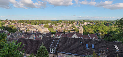
A panoramic view of Bradford from the north-west
Bradford-on-Avon was the site of an early factory for rubber products, established at Kingston Mill by Stephen Moulton in 1848 and later named George Spencer, Moulton and Co. The company was acquired by Avon Rubber, a large manufacturer of rubber products for the automotive and other industries, and production continued until 1993.[17] Today, the town is the headquarters of the Alex Moultonbicycle company and has several other small-scale manufacturing enterprises.
The town's main business is shopping, tourism and day-to-day servicing of a population largely made up of families, commuters and the retired. The town has one mid-sized supermarket on the Elms Cross industrial estate, a short walk from the canal lock, and five convenience stores.[18]
Local consumers founded Bradford-on-Avon Co-operative Society in 1861, which, in the 1960s, united with other consumer co-operatives in the district to merge with a national business.[19] A mini outdoor shopping centre of independent shops, Weavers Walk, which describes itself as an "ethical trading centre", is in the town centre.
The town is an increasingly popular location for films, television adaptations and more; it has played host to Wolf Hall, Creation (a 2009 film about the life of Darwin), Robin of Sherwood and a 1972 film adaptation of The Canterbury Tales. In 2016, The White Princess TV series was filmed in the area.[20]
Transport
Bradford-on-Avon is on the A363Trowbridge to Bath road, which runs through the town from south to north, and crossed over by the B3109 linking Bradford-on-Avon with Melksham and Frome. All other road routes are minor, affording access to local settlements. Bradford-on-Avon is about 15 miles from junction 18 of the M4 motorway at Bath and the same distance from junction 17 at Chippenham.
Running parallel to the railway through the town is the Kennet and Avon Canal. The use of this canal declined as the railways grew but it was restored to full working order during the 1960s, 1970s and 1980s. The canal provides a link through to the Avon at Bath in the west, and the Thames at Reading in the east.
Governance
Bradford-on-Avon civil parish elects a town council with twelve members: six for the North ward and six for the South ward.[22] After the May 2021 elections, there were seven Liberal Democrat and five Ideal Bradford[23] councillors.[22] The town council provides an increasing range of services in the town, building on its historically mostly consultative and ceremonial role. These include provision of youth services, management of significant and growing areas of green space and town facilities, and management of several premises within the town. Members of the council elect one of their number as the town's mayor, for a one-year term.[22] The town council declared a climate emergency in March 2019[24] and has committed to becoming carbon neutral by 2030.[25]
Statutory local government functions – including schools, roads, social services, emergency planning, leisure services, development control, and waste disposal – are carried out by Wiltshire Council, a unitary authority. The North and South wards each elect one member of Wiltshire Council.[26]
For Westminster elections, Bradford-on-Avon is part of the Melksham and Devizes constituency, which was created following a boundary review and first contested at the 2024 general election when it was won by Brian Mathew for the Liberal Democrats.[27] From 2010 to 2024, the town was in the Chippenham constituency.
In 1894 Bradford on Avon became an urban district, the district contained only the parish of Bradford on Avon.[28] On 1 April 1974 the district and parish were abolished and became part of West Wiltshire district.[29] A successor parish was formed covering the same area as the former district and its parish.[30] In 2009 Bradford-on-Avon became part of Wiltshire district.
Education
The town has a secondary school, St Laurence School, founded in 1980 as a result of the merger of Fitzmaurice Grammar School and Trinity Secondary Modern school.[31] There are two primary schools: in the north of the town is Christ Church CofE (VC) Primary School, established as a National school in 1848 and on its present site since 1956,[32] and in the south is Fitzmaurice Primary School, opened in 1928 as Bradford on Avon Council Junior Mixed and Infants' School.[33]
Media
Local news and television programmes are provided by BBC West and ITV West Country. Television signals are received from the Mendip and the local relay transmitters.[34][35]
Bradford-on-Avon has a non-League football club, Bradford Town F.C., who play at the Sports and Social Club on Trowbridge Road. In addition to a bowls & croquet club, tennis courts and a swimming pool, there is also the Bradford-on-Avon Rowing Club, catering for rowing and canoeing from their base opposite Barton Farm country park.[38] Bradford on Avon rugby club, whose first team played in Dorset & Wilts 1 North in 2019–20, have their ground at Winsley, just west of the town.[39]
Wiltshire Music Centre is a purpose-built, 300-seat concert hall within the grounds of St Laurence School that attracts internationally renowned musicians.
Paul Methuen (1613–1667), clothier, lived and worked in Bradford-on-Avon.[40]
John Methuen (1650–1706), was born in Bradford-on-Avon,[41] as was his son Sir Paul Methuen (ca.1672–1757); they were successively British Ambassadors to Portugal.
↑Home, Gordon; Foord, Edward. "Bristol, Bath and Malmesbury, with a Short Account of Bradford on Avon" in the series Cathedrals, abbeys and Famous Churches, J.M.Dent, London, 1925
↑Barker, George Fisher Russell; Doyle, Thomas (reviser) (21 May 2009) [2004]. "Methuen, John (1650–1706), diplomat". Oxford Dictionary of National Biography (online ed.). Oxford University Press doi10.1093/ref:odnb/18628. (Subscription or UK public library membership required.) The first edition of this text is available at Wikisource: Barker, George Fisher Russell (1894). "Methuen, John" . In Lee, Sidney (ed.). Dictionary of National Biography. Vol. 37. London: Smith, Elder & Co. pp. 310–311
↑MacGregor, Rosie (Autumn 2022). "The life and career of acclaimed Guyanian writer Eric D Walrond, who made his home in Bradford on Avon in the 1940s". Guardian Angel. Bradford on Avon Preservation Trust. p.6.
This page is based on this Wikipedia article Text is available under the CC BY-SA 4.0 license; additional terms may apply. Images, videos and audio are available under their respective licenses.