
Gloucestershire is a ceremonial county in South West England. It is bordered by Herefordshire to the north-west, Worcestershire to the north, Warwickshire to the north-east, Oxfordshire to the east, Wiltshire to the south, Bristol and Somerset to the south-west, and the Welsh county of Monmouthshire to the west. The city of Gloucester is the largest settlement and the county town.

Wiltshire is a ceremonial county in South West England. It borders Gloucestershire to the north, Oxfordshire to the north-east, Berkshire to the east, Hampshire to the south-east, Dorset to the south, and Somerset to the west. The largest settlement is Swindon, and Trowbridge is the county town.

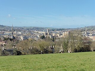
Somerset is a ceremonial county in South West England. It is bordered by the Bristol Channel, Gloucestershire, and Bristol to the north, Wiltshire to the east and the north-east, Dorset to the south-east, and Devon to the south-west. The largest settlement is the city of Bath, and the county town is Taunton.

South West England, or the South West of England, is one of the nine official regions of England in the United Kingdom. It consists of the counties of Cornwall, Dorset, Devon, Gloucestershire, Somerset and Wiltshire. Cities and large towns in the region include Bath, Bristol, Bournemouth, Cheltenham, Exeter, Gloucester, Plymouth and Swindon. It is geographically the largest of the nine regions of England with a land area of 9,203 square miles (23,836 km2), but the third-least populous, with approximately 5.7 million residents.

South Gloucestershire is a unitary authority area in the ceremonial county of Gloucestershire, South West England. Towns in the area include Yate, Chipping Sodbury, Kingswood, Thornbury, Filton, Patchway and Bradley Stoke. The southern part of its area falls within the Greater Bristol urban area surrounding the city of Bristol.

Avon was a non-metropolitan and ceremonial county in the west of England that existed between 1974 and 1996. The county was named after the River Avon, which flows through the area. It was formed from the county boroughs of Bristol and Bath, together with parts of the administrative counties of Gloucestershire and Somerset.
A green belt is a policy, and land-use zone designation used in land-use planning to retain areas of largely undeveloped, wild, or agricultural land surrounding or neighboring urban areas. Similar concepts are greenways or green wedges, which have a linear character and may run through an urban area instead of around it. In essence, a green belt is an invisible line designating a border around a certain area, preventing development of the area and allowing wildlife to return and be established.
Bath and North East Somerset (B&NES) is a unitary authority district in Somerset, South West England. Bath and North East Somerset Council was created on 1 April 1996 following the abolition of the county of Avon. It is part of the ceremonial county of Somerset.

North Somerset is a unitary authority in the ceremonial county of Somerset, England. The council is based in Weston-super-Mare, the area's largest town. The district also contains the towns of Clevedon, Nailsea and Portishead, along with a number of villages and surrounding rural areas. Some southern parts of the district fall within the Mendip Hills, a designated Area of Outstanding Natural Beauty.

Bradford-on-Avon is a town and civil parish in west Wiltshire, England, near the border with Somerset, which had a population of 10,405 at the 2021 census. The town's canal, historic buildings, shops, pubs and restaurants make it popular with tourists.

Dan Norris is a British Labour Party politician serving as the Mayor of the West of England since May 2021. He previously served as the Member of Parliament (MP) for Wansdyke from 1997 to 2010.
Greater Bristol is a term used for the conurbation which contains and surrounds the city of Bristol in the South West of England. There is no official "Greater Bristol" authority, but the term is sometimes used by local, regional and national authorities, and others as a synonym for either the "Bristol Urban Area" or a wider area of the former County of Avon, and by some, TfGB, to refer to the Province of Bristol as defined by C. B. Fawcett (1919) or Derek Senior (1969).

West of England is a combined authority area in South West England, around the River Avon. It is made up of the Bristol, South Gloucestershire, and Bath and North East Somerset unitary authorities. The combined authority is led by the Mayor of the West of England Dan Norris. The city of Bristol is the region's largest population centre. Before the region, from 1974 until 1996, the area was under the County of Avon with North Somerset.

The county of Somerset is in South West England, bordered by the Bristol Channel and the counties of Bristol and Gloucestershire to the north, and Wiltshire to the east, Dorset to the south, and Devon to the west. The climate, influenced by its proximity to the Atlantic Ocean and the prevailing westerly winds, tends to be mild, damp and windy.

The West of England Combined Authority (WECA) is a combined authority within the West of England area, consisting of the local authorities of Bristol, South Gloucestershire, and Bath and North East Somerset. The body has its headquarters in the Redcliffe area of Bristol, and is led by the Mayor of the West of England. The most recent election for this post took place on 6 May 2021, when the Labour candidate Dan Norris was elected on a turnout of 36%.

The inaugural West of England mayoral election was held on 4 May 2017 to elect the Mayor of the West of England metropolitan area. The area is made up of Bath and North East Somerset, Bristol and South Gloucestershire. Subsequent elections will be held every four years. The election was won by Conservative Tim Bowles. The overall turnout for the election was low, with only 29.7% of the electorate voting.
South Bristol is the part of Bristol, England south of the Bristol Avon. It is almost entirely made up of the areas of the city historically in Somerset, and since the abolition of the county Avon, consists of the southern suburbs in the county of Bristol. Definitions sometimes also include areas of North Somerset, including Long Ashton, Nailsea and Backwell.
The West of England Joint Spatial Plan was a plan, published by the English authorities of Bath and North East Somerset, Bristol, North Somerset and South Gloucestershire, of where new housing and other facilities should be built within the former Avon county area. In 2019 it failed to be accredited by the Planning Inspectorate, leading to the possibility of the plan being withdrawn.
