Stoke-on-Trent Green Belt

Last updated

Stoke green belt showing extents, districts and counties.
.mw-parser-output .legend{page-break-inside:avoid;break-inside:avoid-column}.mw-parser-output .legend-color{display:inline-block;min-width:1.25em;height:1.25em;line-height:1.25;margin:1px 0;text-align:center;border:1px solid black;background-color:transparent;color:black}.mw-parser-output .legend-text{}
Stoke-on-Trent green belt
County borders
District/council borders
North West green belt Stoke-on-Trent green belt.svg

Stoke green belt showing extents, districts and counties.
  Stoke-on-Trent green belt
  County borders
  District/council borders
  North West green belt

The Stoke-on-Trent Green Belt is a green belt environmental and planning policy that regulates the rural space throughout mainly the West Midlands region of England. It is contained within the counties of Cheshire and Staffordshire. Essentially, the function of the designated area is to prevent surrounding towns and villages within the Stoke-on-Trent conurbation from further convergence. [1] It is managed by local planning authorities on guidance from central government.

Contents

Purpose

The following policy was stated for the creation of the green belt area by Staffordshire County Council in 1967: [2]

a) The built up areas of Kidsgrove and Biddulph;
b) The settlements of Brown Edge, Endon, Stanley, Bagnall, Stanley Moor, Norton Green, Baddeley Green, Baddeley Edge, Light Oaks, Werrington, Cellarhead, Caverswall, Cookshill, Blythe Bridge, Forsbrook, Meir Heath, Barlaston, Alsagers Bank, Halmer End, Miles Green, Wood Lane, Bignall End and Audley.
Leek with Longsdon; Leek with Cheddleton; Longsdon with Cheddleton; Longsdon with Endon; Cheddleton with Folly Lane; Folly Lane with Wetley Rocks; Wetley Rocks with Cellarhead; Cheadle with Kingsley Holt; Kingsley with Kingsley Holt; Cheadle with Dihorne; Cheadle with Forsbrook; Fulford with Meir Heath; Stone with Oulton; Stone with Yarfield; Tittensor with Barlaston; Barlaston with Stone; Madeley Heath with Madeley; Betley with Audley.

Cheshire County Council set out their policy in 1961: [3]

... prevent the outward spread of development from Greater Manchester, Merseyside and the Potteries."

Geography

Land area taken up by the green belt is 43,836 hectares (438.36 km2; 169.25 sq mi), 0.5% of the total land area of England (2010). [4] The main coverage of the area is within northern Staffordshire, extending into southern Cheshire. [5] The North West Green Belt area surrounding Macclesfield lies close to the Stoke-on-Trent green belt, being just over a mile away at its closest extent from the River Dane which forms the northern boundary for the area.

Landscape facilities and features within the green belt area include the Cudmore Fisheries, Meaford Energy Centre, Millennium Topograph in Downs Banks, JCB Harewood Estate, Rudyard Lake, Meir Heath, Barlaston Common, Chatterley Whitfield Country Park and enterprise centre, Bucknall Reservoir, the Trent & Mersey and Caldon canals, the River Blythe and Trent, Wedgwood Museum and estate, Strongford Sewage Treatment Works, and Trent Vale Pumping Station.

A large portion of the western boundary is formed by the West Coast Main Line railway. Towns on the outer extents of the green belt include Alsager, Cheadle, Congleton, Crewe, Leek, and Stone. Towns and villages within the area include Biddulph, Endon, Kidsgrove, Rudyard, Scholar Green and Swynnerton. Due to the green belt lying across county borders, responsibility and co-ordination lies with several district councils and unitary authorities as these are the local planning authorities.

See also

Related Research Articles

<span class="mw-page-title-main">Stoke-on-Trent</span> City and unitary authority in England

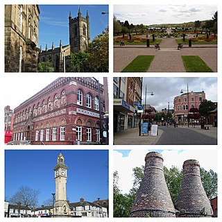
Stoke-on-Trent is a city and unitary authority area in Staffordshire, England, with an area of 36 square miles (93 km2). In 2021, the city had an estimated population of 258,400. It is the largest settlement in Staffordshire and is surrounded by the towns of Newcastle-under-Lyme, Alsager, Kidsgrove and Biddulph, which form a conurbation around the city.

<span class="mw-page-title-main">Staffordshire Moorlands</span> Non-metropolitan district in England

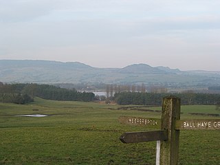
Staffordshire Moorlands is a local government district in Staffordshire, England. Its council is based in Leek, the district's largest town. The district also contains the towns of Biddulph and Cheadle, along with a large rural area containing many villages. North-eastern parts of the district lie within the Peak District National Park.

<span class="mw-page-title-main">BBC Radio Stoke</span> Radio station in Stoke-on-Trent

BBC Radio Stoke is the BBC's local radio station serving Staffordshire and South Cheshire.

<span class="mw-page-title-main">Caldon Canal</span> United Kingdom legislation

Caldon Canal is a branch of the Trent and Mersey Canal which opened in 1779. It runs 18 miles (29 km) from Etruria, Stoke-on-Trent, to Froghall, Staffordshire. The canal has 17 locks and the 76-yard (69 m) Froghall Tunnel.

Blythe Bridge is a village in Staffordshire, England, south-east of Stoke-on-Trent.

<span class="mw-page-title-main">Churnet Valley Railway</span> Heritage railway in Staffordshire, England

The Churnet Valley Railway is a preserved standard gauge heritage railway in the Staffordshire Moorlands of Staffordshire, England. It operates on part of the former Churnet Valley Line which was opened by the North Staffordshire Railway. The railway is roughly 10.5 miles (16.9 km) long from Kingsley and Froghall to Ipstones. The land from Leek Brook Junction to Ipstones was opened by Moorland & City Railways (MCR) in 2010 after they took a lease out from Network Rail. This has subsequently been purchased by the Churnet Valley Railway. The main stations along the line are Kingsley and Froghall, Consall, Cheddleton and Leek Brook. Work has begun to extend the line to the town of Leek which will act as the northern terminus of the line. The line between Leek and Waterhouses has also been reopened as part of the heritage railway as far as Ipstones.

<span class="mw-page-title-main">Staffordshire Moorlands (UK Parliament constituency)</span> Parliamentary constituency in the United Kingdom, 1983 onwards

Staffordshire Moorlands is a constituency represented in the House of Commons of the UK Parliament since 2010 by Karen Bradley, a Conservative who served as Secretary of State for Culture, Media and Sport between 2016 and 2018, before she became Secretary of State for Northern Ireland from 2018 to 2019. As with all constituencies, the constituency elects one Member of Parliament (MP) by the first past the post system of election at least every five years. This seat has seen a swing to the Conservatives at the past four elections.

<span class="mw-page-title-main">Stoke-on-Trent North (UK Parliament constituency)</span>

Stoke-on-Trent North is a constituency represented in the House of Commons of the UK Parliament since 2019 by Jonathan Gullis, a member of the Conservative Party.

<span class="mw-page-title-main">Stone (UK Parliament constituency)</span>

Stone is a constituency in Staffordshire, represented in the House of Commons of the UK Parliament since its 1997 recreation by Sir Bill Cash, a Conservative. On 9 June 2023, he announced his intention to stand down at the next general election.

<span class="mw-page-title-main">Stoke-on-Trent railway station</span> Railway station in Staffordshire, England

Stoke-on-Trent railway station is a mainline railway station serving the city of Stoke-on-Trent, on the Stafford to Manchester branch of the West Coast Main Line. It also provides an interchange between local services running through Cheshire, Staffordshire and Derbyshire.

<span class="mw-page-title-main">Barlaston</span> Human settlement in England

Barlaston is a village and civil parish in the borough of Stafford in the county of Staffordshire, England. It is roughly halfway between the city of Stoke-on-Trent and the small town of Stone. According to the 2001 census the population of the parish was 2,659, rising at the 2011 Census to 2,858.

<span class="mw-page-title-main">Crewe–Derby line</span> Railway line in England

The Crewe–Derby line is a railway line in central England, running from Crewe in a south-easterly direction to Derby, via Stoke-on-Trent and Uttoxeter. Passenger services on the line are provided by East Midlands Railway.

<span class="mw-page-title-main">Meir, Staffordshire</span> Human settlement in England

Meir is a suburb in Stoke-on-Trent, Staffordshire situated between Lightwood and Longton. Meir Park estate extends from Meir uphill to the Meir Heath and Rough Close village hall, located in Meir Heath.

The Sentinel is a daily regional newspaper circulating in the North Staffordshire and South Cheshire areas of England. It is owned by Reach plc and based at Hanley, Stoke-on-Trent.

The Churnet Valley line was one of the three original routes planned and built by the North Staffordshire Railway. Authorised in 1846, the line opened in 1849 and ran from North Rode in Cheshire to Uttoxeter in East Staffordshire. The line was closed in several stages between 1964 and 1988 but part of the central section passed into the hands of a preservation society and today operates as the Churnet Valley Railway.

There are a number of listed buildings in Staffordshire. The term "listed building", in the United Kingdom, refers to a building or structure designated as being of special architectural, historical, or cultural significance. Details of all the listed buildings are contained in the National Heritage List for England. They are categorised in three grades: Grade I consists of buildings of outstanding architectural or historical interest, Grade II* includes significant buildings of more than local interest and Grade II consists of buildings of special architectural or historical interest. Buildings in England are listed by the Secretary of State for Culture, Media and Sport on recommendations provided by English Heritage, which also determines the grading.

<span class="mw-page-title-main">Cheadle Rural District</span> Former rural district in Staffordshire, England

Cheadle Rural District was a rural district in the administrative county of Staffordshire, England from 1894 to 1974, covering an area in the north of the county centred on the small town of Cheadle.

References

  1. Fawcett, Tony. "Green Belts: A greener future - Campaign to Protect Rural England".
  2. "Joint local plan Green Belt assessment november 2017 - Stoke-on-Trent". www.stoke.gov.uk.
  3. "Cheshire East Local Plan Evidence Base Green Belt Assessment - September 2013" (PDF). www.cheshireeast.gov.uk. Cheshire East Council. ...the original intent for the area of Green Belt in Cheshire East was to prevent the outward spread of development from Greater Manchester and the Potteries. These original draft Green Belt proposals were submitted to the Ministry of Housing and Local Government in 1961 and although they were not formally approved at this time, Green Belt control has been operated in the area concerned ever since submission.
  4. "Green Belts in England: Key facts - A series of factsheets on England's 14 Green Belts".
  5. Cheshire East Council. "Cheshire East Local Plan Local Plan Strategy 2010 - 2030 Adopted 27 July 2017" (PDF). www.cheshireeast.gov.uk. 2.83 The North Staffordshire Green Belt surrounds Stoke and Newcastle with its northernmost extent covering part of Cheshire East (known locally as the South Cheshire Green Belt) – south of Alsager and Congleton and south east of Crewe.