
Cheshire is a ceremonial county in North West England. It is bordered by Merseyside to the north-west, Greater Manchester to the north-east, Derbyshire to the east, Staffordshire to the south-east, and Shropshire to the south; to the west it is bordered by the Welsh counties of Flintshire and Wrexham, and has a short coastline on the Dee Estuary. Warrington is the largest settlement, and the city of Chester is the county town.

Lancashire is a ceremonial county in North West England. It is bordered by Cumbria to the north, North Yorkshire and West Yorkshire to the east, Greater Manchester and Merseyside to the south, and the Irish Sea to the west. The largest settlement is Blackpool, and the county town is the city of Preston.

Greater Manchester is a ceremonial county in North West England. It borders Lancashire to the north, Derbyshire and West Yorkshire to the east, Cheshire to the south, and Merseyside to the west. Its largest settlement is the city of Manchester.

Metropolitan counties are a subdivision of England which were originally used for local government. There are six metropolitan counties: Greater Manchester, Merseyside, South Yorkshire, Tyne and Wear, West Midlands and West Yorkshire.

West Yorkshire is a metropolitan and ceremonial county in the Yorkshire and the Humber region of England. It borders North Yorkshire to the north and east, South Yorkshire and Derbyshire to the south, Greater Manchester to the south-west, and Lancashire to the west. The city of Leeds is the largest settlement.
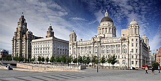
Merseyside is a ceremonial and metropolitan county in North West England. It borders Lancashire to the north, Greater Manchester to the east, Cheshire to the south, the Welsh county of Flintshire across the Dee Estuary to the southwest, and the Irish Sea to the west. The largest settlement is the city of Liverpool.
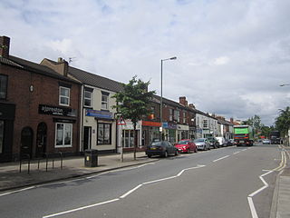
Newton-le-Willows is a market town in the Metropolitan Borough of St Helens, Merseyside, England. The population at the 2021 census was 24,642. Newton-le-Willows is on the eastern edge of St Helens, south of Wigan and north of Warrington.

The counties of England are divisions of England. There are currently 48 ceremonial counties, which have their origin in the historic counties of England established in the Middle Ages. The current ceremonial counties are the result of the Lieutenancies Act 1997 and are based on the Local Government Act 1972 administrative counties which included a number of new counties such as Greater Manchester and Tyne and Wear. However, some counties introduced by the Local Government Act 1972, including Avon, Cleveland and Humberside no longer exist. The term "county", relating to any of its meanings, is used as the geographical basis for a number of institutions such as police and fire services, sports clubs and other non-government organisations.

The Local Government Act 1972 is an act of the Parliament of the United Kingdom that reformed local government in England and Wales on 1 April 1974. It was one of the most significant Acts of Parliament to be passed by the Heath Government of 1970–74.

Lancashire is a county of England, in the northwest of the country. The county did not exist in 1086, for the Domesday Book, and was apparently first created in 1182, making it one of the youngest of the traditional counties.

Metropolitan and non-metropolitan counties are one of the four levels of subdivisions of England used for the purposes of local government outside Greater London and the Isles of Scilly. As originally constituted, the metropolitan and non-metropolitan counties each consisted of multiple districts, had a county council and were also the counties for the purposes of Lieutenancies. Later changes in legislation during the 1980s and 1990s have resulted in counties with no county council and 'unitary authority' counties with no districts. Counties for the purposes of Lieutenancies are now defined separately, based on the metropolitan and non-metropolitan counties.

The Greater Manchester Built-up Area is an area of land defined by the Office for National Statistics (ONS), consisting of the large conurbation that encompasses the urban element of the city of Manchester and the metropolitan area that forms much of Greater Manchester in North West England. According to the United Kingdom Census 2011, the Greater Manchester Built-up Area has a population of 2,553,379 making it the second most populous conurbation in the United Kingdom after the Greater London Built-up Area. This was an increase of 14% from the population recorded at the United Kingdom Census 2001 of 2,240,230, when it was known as the Greater Manchester Urban Area.

Lancashire County Council is the local authority for the non-metropolitan county of Lancashire, England. It consists of 84 councillors. Since the 2017 election, the council has been under Conservative control. Before the 2009 Lancashire County Council election, the county had been under Labour control since 1989.
The Local Government Act 1958 was an Act of the Parliament of the United Kingdom affecting local government in England and Wales outside London. Among its provisions it included the establishment of Local Government Commissions to review the areas and functions of local authorities, and introduced new procedures for carrying these into action.

Halton Borough Council is the local authority for the Borough of Halton, incorporating the towns of Runcorn and Widnes and the parishes of Daresbury, Hale, Moore and Preston Brook. It is a constituent council of Liverpool City Region Combined Authority.

This is an as yet incomplete list of listed buildings in England, which are the majority of the listed buildings of the United Kingdom.

The Borough of Warrington is a unitary authority area with borough status in the ceremonial county of Cheshire, England. The borough is centred around the town of Warrington, and extends out into outlying villages of Lymm and Great Sankey and the town of Birchwood.

The South and West Yorkshire Green Belt is an environmental and planning policy that regulates the rural space within the Yorkshire and the Humber region of England. The function of the green belt policy in South and West Yorkshire is to manage development around the cities, towns and villages in the West Yorkshire Urban Area, the Sheffield urban area, Barnsley and Doncaster, to discourage urban sprawl. It is managed by local planning authorities on guidance from central government.

The Stoke-on-Trent Green Belt is a green belt environmental and planning policy that regulates the rural space throughout mainly the West Midlands region of England. It is contained within the counties of Cheshire and Staffordshire. Essentially, the function of the designated area is to prevent surrounding towns and villages within the Stoke-on-Trent conurbation from further convergence. It is managed by local planning authorities on guidance from central government.
