
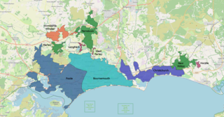
Dorset is a ceremonial county in South West England. It is bordered by Somerset to the north-west, Wiltshire to the north and the north-east, Hampshire to the east, the Isle of Wight across the Solent to the south-east, the English Channel to the south, and Devon to the west. The largest settlement is Bournemouth, and the county town is Dorchester.

Bournemouth is a coastal resort town on the south coast in the Bournemouth, Christchurch and Poole unitary authority area in the ceremonial county of Dorset, England. The town's urban subdivision had a population of 187,503 at the 2011 census making it the largest town in the county; the town is part of the South East Dorset conurbation, which has a population of 465,000.
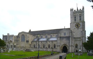
Christchurch is a town and civil parish on the south coast of Dorset, England. The parish had a population of 31,372 in 2021. It adjoins Bournemouth to the west, with the New Forest to the east. Part of the historic county of Hampshire, Christchurch was a borough within the administrative county of Dorset from 1974 until 2019, when it became part of the new Bournemouth, Christchurch and Poole unitary authority.

East Dorset was a local government district in Dorset, England. Its council met in Wimborne Minster between 2016 and 2019.
New Forest is a local government district in Hampshire, England. Its council is based in Lyndhurst, although the largest town is Totton. The district also includes the towns of Fordingbridge, Lymington, New Milton and Ringwood. The district is named after and covers most of the New Forest National Park, which occupies much of the central part of the district. The main urban areas are around the periphery of the forest. The district has a coastline onto the Solent to the south and Southampton Water to the east.
The South East Dorset conurbation is a multi-centred conurbation on the south coast of Dorset in England.
Bournemouth Borough Council was the local authority for Bournemouth in Dorset, England between 1974 and 2019. Prior to 1974 Bournemouth had been a county borough within Hampshire. Under the Local Government Act 1972 Bournemouth became a non-metropolitan district within Dorset on 1 April 1974, with the same boundaries as the former county borough. On 1 April 1997 it became a unitary authority, taking over the functions previously provided for the area by Dorset County Council. In 2019 the council was abolished, merging with Christchurch and Poole to form Bournemouth, Christchurch and Poole.

Christchurch Borough Council in Dorset, England, existed from 1974 to 2019, when it was abolished and subsumed into Bournemouth, Christchurch and Poole Council.

Holdenhurst is a small isolated village situated in the green belt land of the north-east suburbs of Bournemouth, England. The village comprises fewer than 30 dwellings, two farms and the parish church. There are no shops and few local facilities in the village.

The unitary authorities of England are a type of local authority responsible for all local government services in an area. They combine the functions of a non-metropolitan county council and a non-metropolitan district council, which elsewhere in England provide two tiers of local government.
Dorset County Council (DCC) was the county council for the county of Dorset in England. It provided the upper tier of local government, below which were district councils, and town and parish councils. The county council had 46 elected councillors and was based at County Hall in Dorchester. The council was abolished on 31 March 2019 as part of structural changes to local government in Dorset.

Bournemouth Borough Council was the local authority of Bournemouth in Dorset, England and ceased to exist on 1 April 2019. It was a unitary authority, although between 1974 and 1997 it was an administrative district council with Dorset. Previously most of the borough was part of Hampshire.
The Dorset History Centre is the archive service for the county of Dorset, England. It collects, stores, preserves and makes available documents relating to the history of Dorset. It is a local authority archive service, jointly funded by Dorset Council, and Bournemouth, Christchurch and Poole Council, serving both authorities. The oldest document in the archives is from 965 AD.
Burton is a village in the civil parish of Burton and Winkton, administered as part of the Bournemouth, Christchurch and Poole unitary authority, in the historic county of Hampshire and the ceremonial county of Dorset, England. The parish is elevated above the Avon Valley on a gravel plateau and includes the village of Burton, plus the hamlets of Winkton, Holfleet, North Bockhampton, Middle Bockhampton and South Bockhampton. The toponymy of Burton suggests an Anglo-Saxon settlement but the first record of the name appears in twelfth-century records. It is thought that this is because it has always been viewed as an extension of Christchurch. Certainly, there is evidence of human habitation there as far back as the mesolithic. The oldest existing parts date back to at least the early 18th century.

Bournemouth, Christchurch and Poole (BCP) is a unitary authority area in the ceremonial county of Dorset, England. It was created on 1 April 2019 by the merger of the areas that were previously administered by the unitary authorities of Bournemouth and Poole, and the non-metropolitan district of Christchurch. The authority covers much of the area of the South Dorset conurbation.

Dorset Council is a unitary local authority for the district of Dorset, encompassing almost all of the county of the same name (Dorset) except for the district of Bournemouth, Christchurch and Poole. Created in April 2019, the council was formed when the county moved from a two-tier county council and district council system to a one-tier system, with the county divided into two districts administered by two independent unitary authorities.
Structural changes to local government in England took place between 2019 and 2023. Some of these changes continue the trend of new unitary authorities being created from other types of local government districts, which was a policy of Communities Secretary Robert Jenrick from 2019.

Dorset is a unitary authority area, existing since 1 April 2019, in the ceremonial county of Dorset, England. It covers all of the ceremonial county except for Bournemouth, Christchurch and Poole. The council of the district is Dorset Council, which is in effect Dorset County Council re-constituted so as to be vested with the powers and duties of five district councils which were abolished, and shedding its partial responsibility for and powers in Christchurch.

The Alliance for Local Living (ALL) was a minor localist party and political group based in Dorset, with separate branches in the two authorities, ALL for Bournemouth, Christchurch and Poole and ALL for Dorset. The BCP office was based in Poole, whilst the Dorset office was based in Weymouth. The party was deregistered in November 2023, at which point it had four councillors on Dorset Council, who continued to sit together as an informal grouping.

The Town Hall, Christchurch is a municipal building in Christchurch, Dorset, England. The building, which incorporates a room known as the mayor's parlour on the first floor, and is a Grade II listed building. It is currently the base of Christchurch Town Council.
