
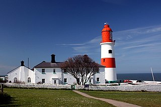
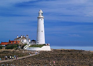
North East England is one of nine official regions of England at the first level of ITL for statistical purposes. The region has three current administrative levels below the region level in the region: combined authority, unitary authority or metropolitan borough, and civil parishes. They are also multiple divisions without administrative functions; ceremonial county, emergency services, built-up areas and historic county. The largest settlements in the region are Newcastle upon Tyne, Middlesbrough, Sunderland, Gateshead, Darlington, Hartlepool and Durham.

Northumberland is a ceremonial county in North East England, bordering Scotland. It is bordered by the Scottish Borders to the north, the North Sea to the east, Tyne and Wear and County Durham to the south, and Cumbria to the west. The town of Blyth is the largest settlement while Alnwick is the historic county town.

Newcastle upon Tyne, or simply Newcastle, is a city and metropolitan borough in Tyne and Wear, England. It is England's northernmost metropolitan borough, located on the River Tyne's northern bank opposite Gateshead to the south. It is the most populous settlement in the Tyneside conurbation and North East England.
Tyne and Wear is a ceremonial county in North East England. It borders Northumberland to the north and County Durham to the south, and the largest settlement is the city of Newcastle upon Tyne.

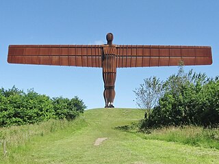
Gateshead is a town in the Gateshead Metropolitan Borough of Tyne and Wear, England. It is on the River Tyne's southern bank. The town's attractions include the twenty metre tall Angel of the North sculpture on the town's southern outskirts, The Glasshouse International Centre for Music and the Baltic Centre for Contemporary Art. The town shares the Millennium Bridge, Tyne Bridge and multiple other bridges with Newcastle upon Tyne.
South Tyneside is a metropolitan borough in the metropolitan county of Tyne and Wear, England.
North Tyneside is a metropolitan borough in the metropolitan county of Tyne and Wear, England. It forms part of the greater Tyneside conurbation. North Tyneside Council is headquartered at Cobalt Park, Wallsend.

Tyneside is a built-up area across the banks of the River Tyne in Northern England. Residents of the area are commonly referred to as Geordies. The whole area is surrounded by the North East Green Belt.
The Metropolitan Borough of Gateshead is a metropolitan borough in the metropolitan county of Tyne and Wear, England. It includes Gateshead, Rowlands Gill, Whickham, Blaydon, Ryton, Felling, Birtley, Pelaw, Dunston and Low Fell. The borough forms part of the Tyneside conurbation, centred on Newcastle upon Tyne. At the 2021 census, the borough had a population of 196,154.

Tyne and Wear Fire and Rescue Service, formerly known as the Tyne and Wear Metropolitan Fire Brigade, is the fire and rescue service (FRS) for the metropolitan boroughs of Newcastle Upon Tyne, Gateshead, North Tyneside, South Tyneside and Sunderland, serving a population of 1.14 million people across an area of 208 square miles (540 km2). Tyne and Wear Fire and Rescue Authority is responsible for the running of the service, as well as the publication of performance indicators in accordance with its legal obligations. In April 2017, Chris Lowther was appointed chief fire officer.

Tyne and Wear is a metropolitan area covering the cities of Newcastle upon Tyne and Sunderland, as well as North and South Tyneside, Gateshead and Washington.

The Tyneside Passenger Transport Executive was the operations arm of the Tyneside Passenger Transport Authority, created by the Transport Act 1968. and came into operation on 1 January 1970.

The North East Combined Authority (NECA), officially the Durham, Gateshead, South Tyneside and Sunderland Combined Authority, is one of three combined authorities in North East England. It was created in 2014, and currently consists of the City of Sunderland; Metropolitan Borough of Gateshead, South Tyneside; and Durham County local authorities.

The South West Hampshire & South East Dorset Green Belt is a green belt environmental and planning policy that regulates the rural space in the South West region of England. It is mainly within the county of Dorset, extending cross border into Hampshire. Essentially, the function of the belt is to control development expansion in the South East Dorset conurbation and outlying towns and villages. It is managed by local planning authorities on guidance from central government.

The North of Tyne Combined Authority is a mayoral combined authority which consists the local authorities of Newcastle upon Tyne, North Tyneside, and Northumberland, all in North East England. The authority came into being on 2 November 2018 under the statutory name Newcastle upon Tyne, North Tyneside and Northumberland Combined Authority. The three local authorities previously formed part of the North East Combined Authority, which still exists in a smaller form. The two combined authorities cooperate on the North East Joint Transport Committee.

The North East Joint Transport Committee is a special joint committee of the North East Combined Authority and the North of Tyne Combined Authority. It is responsible for public transport policy in Tyne and Wear, County Durham and Northumberland in England. It is the governing body of Nexus, the trading name of the Tyne and Wear Passenger Transport Executive. The inaugural meeting was held on 20 November 2018.
The ceremonial county of Tyne and Wear has returned 12 MPs to the UK Parliament since 2010. It was created under the Local Government Act 1972, which came into effect on 1 April 1974, comprising the urban areas around the mouths of the Rivers Tyne and Wear, previously parts of the historic counties of Northumberland and Durham.
The North East Mayoral Combined Authority (NEMCA) is a combined authority in North East England. NEMCA has a directly-elected Mayor and seven member councils; two county unitary authorities and five metropolitan boroughs.
