Tyneside

Last updated

Tyneside
Geordieland
Newcastle-Gateshead
Built-up area
Tyne Bridge - Newcastle Upon Tyne - England - 2004-08-14.jpg
The River Tyne between Gateshead and Newcastle
TynesideBUA.png
Built-up area's sub divisions
Northern England location map.PNG
Red pog.svg
Tyneside
Location of Tyneside in northern England
Coordinates: 54°59′15″N1°27′30″W / 54.98750°N 1.45833°W / 54.98750; -1.45833
Sovereign state United Kingdom
Country England
Region North East
County Tyne and Wear
Population
 (2011)
  Total774,891
Time zone GMT (UTC)
  Summer (DST) UTC+1 (BST)

Tyneside is a built-up area across the banks of the River Tyne in Northern England. Residents of the area are commonly referred to as Geordies. The whole area is surrounded by the North East Green Belt.

Contents

The population of Tyneside as published in the 2011 census was 774,891, making it the eighth most-populous urban area in the United Kingdom. [1] In 2013, the estimated population was 832,469. [2]

Politically, the area is mainly covered by the metropolitan boroughs of Newcastle-upon-Tyne, Gateshead, North Tyneside and South Tyneside. The boroughs on the Tyne are joint with Wearside which is in both the ceremonial counties of Durham (Chester-le-Street) and Tyne and Wear.

Settlements

Aerial view of Tyneside which includes North Tyneside, Metropolitan Borough of Gateshead, parts of South Tyneside and parts of Northumberland. Newcastle bridges upstream.jpg
Aerial view of Tyneside which includes North Tyneside, Metropolitan Borough of Gateshead, parts of South Tyneside and parts of Northumberland.

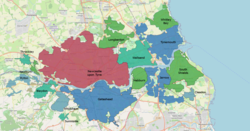
The ONS 2011 census had 774,891 census respondents inside the "Tyneside Built-up Area" or "Tyneside Urban Area". [3] These figures are a decline from 879,996; [4] this loss was mainly due to the ONS reclassifying Hetton-le-Hole, Houghton-le-Spring, Chester-le-Street and Washington in the Wearside Built-up Area instead of Tyneside. In both the 2001 and 2011 census the area was given the following subdivisions; Gateshead, Jarrow and Tynemouth had boundary changes:

Map of the Tyneside Built-Up Area with subdivisions TynesideBUA.png
Map of the Tyneside Built-Up Area with subdivisions
SubdivisionPopulation
(2011)
Population
(2001)
Newcastle 292,200259,573
Gateshead 120,04678,403
South Shields 75,33782,854
Tynemouth 67,51917,056
Wallsend 43,82642,843
Jarrow 43,43127,525

Geordies

The people of Newcastle, called "Geordies", have a reputation for their distinctive dialect and accent. Newcastle may have been given this name, a local diminutive of the name "George", because their miners used George Stephenson's safety lamp (invented in 1815 and called a "Georgie lamp") to prevent firedamp explosions, rather than the Davy lamp used elsewhere. An alternative explanation relates that during the Jacobite risings of 1715 and 1745 the people of Newcastle declared their allegiance to the Hanoverian Kings of Great Britain, George I and George II; whereas the rest of the county of Northumberland, to the north, stood loyal to James Francis Edward Stuart.

Coal production

While Newcastle upon Tyne had been an important local centre since Roman times, and was a major local market town from the Middle Ages, the development of Newcastle and Tyneside is owed to coal mining. Coal was first known to be dug in Tyneside from superficial seams in around 1200, but there is some evidence from Bede's writings that it may have been dug as early as 800 AD. Coal was dug from local drift mines and bell pits, and although initially only used locally, it was exported from the port of Newcastle from the mid 14th century onwards. Tyneside had a strategic advantage as far as the coal trade was concerned, because collier brigs could be loaded with coal on the Tyne and could sail down the east coast to London. In fact, the burgesses of Newcastle formed a cartel, and were known as the Hostmen. The Hostmen were able gain a monopoly over all of the coal exported from Tyneside, a monopoly which lasted a considerable time. A well-known group of workers on the river were the keelmen who handled the keels, boats that carried the coal from the riverbanks to the waiting colliers. [5]

Steel and shipbuilding

Tyneside shipyards during the Second World War Cecil Beaton Photographs- Tyneside Shipyards, 1943 DB46.jpg
Tyneside shipyards during the Second World War

The Derwent (valley), a major tributary of the Tyne that rises in County Durham, saw the development of the steel industry from around 1600 onwards. This was led by German immigrant cutlers and sword-makers, probably from around Solingen, who fled from religious persecution at home and settled in the then village of Shotley Bridge, near Consett.

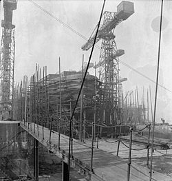
The combination of coal and steel industries in the area was the catalyst for further major industrial development in the 19th century, including the shipbuilding industry; at its peak, the Tyneside shipyards were one of the largest centres of shipbuilding in the world and built an entire navy for Japan in the first decade of the 20th century. There is still a working shipyard in Wallsend.

Professional competitive rowing on the Tyne

From early in the 19th century, it was a custom to hold boat races on the Tyne. The Tyne had a large number of keelmen and wherrymen, who handled boats as part of their jobs. As on the River Thames, there were competitions to show who was the best oarsman. As a wherryman did not earn very much, competitive rowing was seen as a quick way of earning extra money. Regattas were held, and provided modest prizes for professionals, but the big money was made in challenge races, in which scullers or boat crews would challenge each other to a race over a set distance for a side stake. The crews would usually have backers, who would put up the stake money, as they saw the chance of financial gain from the race. In the days before mass attendances at football matches, races on the river were enormously popular, with tens of thousands attending. Betting would go on both before and during a race, the odds changing as the fortunes of the contestants changed. Contestants who became champions of the Tyne would often challenge the corresponding champions of the River Thames, and the race would be arranged to take place on one of the two rivers.

Rivalry between the Tyne and the Thames was very keen, and rowers who upheld the honour of the Tyne became local heroes. Three such oarsmen, who came from humble backgrounds and became household names in the North East, were Harry Clasper, Robert Chambers and James Renforth. Clasper was a champion rower in fours, as well as an innovative boat designer and a successful rowing coach. Chambers and Renforth were oarsmen who excelled at sculling. Both held the World Sculling Championship at different times. The popularity of all three men was such that when they died, many thousands attended their funeral processions, and magnificent funeral monuments were provided by popular subscription in all three cases. At the end of the 19th century professional competitive rowing on the Tyne began a gradual decline and would die out entirely leaving the amateur version. [6]

Rapper dancing

Despite its rapid growth in the Industrial Revolution, Tyneside developed one peculiar local custom, the rapper sword dance, which later spread to neighbouring areas of Northumberland and County Durham.

Industrial decline and regeneration

During the 1970s and 1980s, there was major industrial decline in the traditional British heavy industries, and Tyneside was hit hard. High unemployment rates and the national [Thatcher] government's resolve to push through with economic transformation led to great social unrest with strikes and occasional rioting in depressed areas.

From the late 1980s onward, an improving national economy and local regeneration helped the area to recover, and although unemployment is still a problem compared with some other areas of Britain, expansion of new industries such as tourism, science and high-technology, has fuelled local development, especially in Newcastle upon Tyne and Gateshead.

Economy

This is a chart of trend of regional gross value added of Tyneside at current basic prices published by the Office for National Statistics with figures in millions of British pounds sterling. [7]

YearRegional gross value added [lower-alpha 1] Agriculture [lower-alpha 2] Industry [lower-alpha 3] Services [lower-alpha 4]
19957,68892,2445,435
20009,93082,5677,356
200311,89592,8659,021
  1. Components may not sum to totals due to rounding
  2. Includes hunting and forestry
  3. Includes energy and construction
  4. Includes financial intermediation services indirectly measured

Related Research Articles

<span class="mw-page-title-main">North East England</span> Region of England

North East England is one of nine official regions of England at the first level of ITL for statistical purposes. The region has three current administrative levels below the region level in the region: combined authority, unitary authority or metropolitan borough, and civil parishes. They are also multiple divisions without administrative functions; ceremonial county, emergency services, built-up areas and historic county. The largest settlements in the region are Newcastle upon Tyne, Middlesbrough, Sunderland, Gateshead, Darlington, Hartlepool and Durham.

<span class="mw-page-title-main">Geordie</span> Northern English dialect and demonym native to Tyneside

Geordie is a nickname for a person from the Tyneside area of North East England and the dialect used by its inhabitants, also known in linguistics as Tyneside English or Newcastle English. There are different definitions of what constitutes a Geordie. The term is used and has been historically used to refer to the people of the North East. A Geordie can also specifically be a native of Tyneside and the surrounding areas. Not everyone from the North East of England identifies as a Geordie.

<span class="mw-page-title-main">Tyne and Wear</span> County of England

Tyne and Wear is a ceremonial county in North East England. It borders Northumberland to the north and County Durham to the south, and the largest settlement is the city of Newcastle upon Tyne.

<span class="mw-page-title-main">Gateshead</span> Town in Tyne and Wear, England

Gateshead is a town in the Gateshead Metropolitan Borough of Tyne and Wear, England. It is on the River Tyne's southern bank. The town's attractions include the twenty metre tall Angel of the North sculpture on the town's southern outskirts, The Glasshouse International Centre for Music and the Baltic Centre for Contemporary Art. The town shares the Millennium Bridge, Tyne Bridge and multiple other bridges with Newcastle upon Tyne.

<span class="mw-page-title-main">South Tyneside</span> Metropolitan borough in England

South Tyneside is a metropolitan borough in the metropolitan county of Tyne and Wear, England.

<span class="mw-page-title-main">South Shields</span> Town in Tyne and Wear, England

South Shields is a coastal town in South Tyneside, Tyne and Wear, England; it is on the south bank of the mouth of the River Tyne. The town was once known in Roman times as Arbeia and as Caer Urfa by the Early Middle Ages. It is the fourth largest settlement in Tyne and Wear, after Newcastle upon Tyne, Sunderland and Gateshead.

<span class="mw-page-title-main">Wearside</span> Built-up area in England

Wearside is a built-up area in County Durham and Tyne and Wear, England. It is named after the River Wear which flows through it and traditionally all in the County of Durham.

<span class="mw-page-title-main">History of Newcastle upon Tyne</span> Development of a city in North East England

The history of Newcastle upon Tyne dates back almost 2,000 years, during which it has been controlled by the Romans, the Angles and the Norsemen amongst others. Newcastle upon Tyne was originally known by its Roman name Pons Aelius. The name "Newcastle" has been used since the Norman conquest of England. Due to its prime location on the River Tyne, the town developed greatly during the Middle Ages and it was to play a major role in the Industrial Revolution, being granted city status in 1882. Today, the city is a major retail, commercial and cultural centre.

<span class="mw-page-title-main">Newburn</span> Human settlement in England

Newburn is a village and district of Newcastle upon Tyne, in Tyne and Wear, England. Situated on the North bank of the River Tyne, it is built rising up the valley from the river. It is situated approximately 5 miles (8 km) from the city centre, 14 miles (23 km) east of Hexham and 13 miles (21 km) south south west of Morpeth. In the 2001 census, the population was given as 9,301, increasing to 9,536 at the 2011 Census. Newburn is in the Newcastle upon Tyne district of Tyne and Wear and is part of the parliamentary constituency of Newcastle upon Tyne North.

<span class="mw-page-title-main">Harry Clasper</span> English professional rower & boat builder (1812-1870)

Harry Clasper was a professional rower and boat builder from Tyneside in England. He was an innovative boat designer who pioneered the development of the racing shell and the use of outriggers. He is said to have invented spoon-shaped oars.

Harry Kelley (1832–1914) was a professional oarsman on the Thames. He became the Tyne, Thames, English and World Sculling Champion, a title he won four times.

<span class="mw-page-title-main">Victoria Tunnel (Newcastle)</span> Subterranean wagonway under Newcastle upon Tyne, England

The Victoria Tunnel is a subterranean wagonway that runs under Newcastle upon Tyne, England, from the Town Moor down to the River Tyne. It was built between 1839 and 1842 to transport coal from Leazes Main Colliery in Spital Tongues, to riverside staithes (jetties), ready for loading onto boats for export.

<span class="mw-page-title-main">Hostmen of Newcastle upon Tyne</span> Coal merchant business monopoly cartel

The Incorporated Company of Hostmen of Newcastle upon Tyne, often called the Hostmen's Company of Newcastle, is a company incorporated by royal charter of 22 March 1599/1600. Analogous to a livery company of the City of London, it still exists. It is best known to economic historians as a cartel of businessmen who formed a monopoly to control the export of coal from the River Tyne in North East England. They were so known from the medieval practice of "hosting", whereby local businessmen provided visiting merchants with accommodation and introduced them to local traders. The Hostmen acted as middlemen with whom the coal producers and those who shipped the coal to London and elsewhere were forced to deal.

The Keelmen of Tyne and Wear were a group of men who worked on the keels, large boats that carried the coal from the banks of both rivers to the waiting collier ships. Because of the shallowness of both rivers, it was difficult for ships of any significant draught to move up river and load with coal from the place where the coal reached the riverside. Thus the need for shallow-draught keels to transport the coal to the waiting ships. The keelmen formed a close-knit and colourful community on both rivers until their eventual demise late in the nineteenth century.

<span class="mw-page-title-main">Robert Chambers (oarsman)</span> English oarsman and world sculling champion

Robert Chambers was a Tyneside professional oarsman. He became the Tyne, Thames, English and World Sculling Champion.

<span class="mw-page-title-main">James Renforth</span> British rower

James Renforth was an English Tyneside professional oarsman. He became the World Sculling Champion in 1868 and was one of three great Tyneside oarsmen, the other two being Harry Clasper and Robert Chambers.

Joseph Henry Sadler was a British professional rower who twice won the World Sculling Championship. Before 1876, the English Sculling Championship was considered to be the premier event in professional sculling. In 1876, the English Title gained the World status and earlier winners were retrospectively given the title of World Champion.

Rowland "Rowley" Harrison (1841–1897) was a Tyneside poet and singer/songwriter, from Gateshead in County Durham. Possibly his best known work is "Geordy Black", an example of Geordie dialect.

William Dunbar was a Gateshead songwriting collier who died at the age of 21.

References

  1. Pointer, Graham. "The UK's major urban areas" (PDF). statistics.gov.uk. Retrieved 8 April 2007.
  2. "Mid-2012 Population Estimates". Gateshead.gov.uk. August 2013. Archived from the original on 29 April 2014. Retrieved 27 January 2014.
  3. "2011 Census - Built-up areas". ONS. Archived from the original on 21 September 2013. Retrieved 1 July 2013.
  4. "UK Government Web Archive". Archived from the original on 22 October 2012. Retrieved 3 October 2013.
  5. Finch, Roger (1973). Coals from Newcastle. The Lavenham Press. ISBN   0-900963-39-5.
  6. Whitehead, Ian (2002). The Sporting Tyne. ISBN   0-901273-42-2.
  7. Office for National Statistics. pp. 240–253 Archived 2007-12-01 at the Wayback Machine .