An urban growth boundary, or UGB, is a regional boundary, set in an attempt to control urban sprawl by, in its simplest form, mandating that the area inside the boundary be used for urban development and the area outside be preserved in its natural state or used for agriculture. Legislating for an "urban growth boundary" is one way, among many others, of managing the major challenges posed by unplanned urban growth and the encroachment of cities upon agricultural and rural land.

In urban planning, zoning is a method in which a municipality or other tier of government divides land into "zones", each of which has a set of regulations for new development that differs from other zones. Zones may be defined for a single use, they may combine several compatible activities by use, or in the case of form-based zoning, the differing regulations may govern the density, size and shape of allowed buildings whatever their use. The planning rules for each zone determine whether planning permission for a given development may be granted. Zoning may specify a variety of outright and conditional uses of land. It may indicate the size and dimensions of lots that land may be subdivided into, or the form and scale of buildings. These guidelines are set in order to guide urban growth and development.
Regional planning deals with the efficient placement of land-use activities, infrastructure, and settlement growth across a larger area of land than an individual city or town. Regional planning is related to urban planning as it relates land use practices on a broader scale. It also includes formulating laws that will guide the efficient planning and management of such said regions. Regional planning can be comprehensive by covering various subjects, but it more often specifies a particular subject, which requires region-wide consideration.

Land use planning is the process of regulating the use of land by a central authority. Usually, this is done to promote more desirable social and environmental outcomes as well as a more efficient use of resources. More specifically, the goals of modern land use planning often include environmental conservation, restraint of urban sprawl, minimization of transport costs, prevention of land use conflicts, and a reduction in exposure to pollutants. In the pursuit of these goals, planners assume that regulating the use of land will change the patterns of human behavior, and that these changes are beneficial. The first assumption, that regulating land use changes the patterns of human behavior is widely accepted. However, the second assumption - that these changes are beneficial - is contested, and depends on the location and regulations being discussed.

The regional chambers of England were a group of indirectly elected regional bodies that were created by the provisions of the Regional Development Agencies Act 1998. There were eight regional chambers, one for each of the regions of England except Greater London, which had opted for an elected mayor and assembly in 1998. All eight regional chambers had adopted the title "regional assembly" or "assembly" as part of their name, though this was not an official status in law. The chambers were abolished over a two-year period between 31 March 2008 and 31 March 2010 and some of their functions were assumed by newly established local authority leaders' boards.
Spatial planning mediates between the respective claims on space of the state, market, and community. In so doing, three different mechanisms of involving stakeholders, integrating sectoral policies and promoting development projects mark the three schools of transformative strategy formulation, innovation action and performance in spatial planning
Town and country planning in the United Kingdom is the part of English land law which concerns land use planning. Its goal is to ensure sustainable economic development and a better environment. Each country of the United Kingdom has its own planning system that is responsible for town and country planning, which outside of England is devolved to the Northern Ireland Assembly, the Scottish Parliament and the Senedd.
Regional spatial strategies (RSS) provided regional level planning frameworks for the regions of England outside London. They were introduced in 2004. Their revocation was announced by the new Conservative/Liberal Democrat government on 6 July 2010.

The London Plan is the statutory spatial development strategy for the Greater London area in the United Kingdom that is written by the Mayor of London and published by the Greater London Authority. It is updated from time to time.

Environmental planning is the process of facilitating decision making to carry out land development with the consideration given to the natural environment, social, political, economic and governance factors and provides a holistic framework to achieve sustainable outcomes. A major goal of environmental planning is to create sustainable communities, which aim to conserve and protect undeveloped land.

A local development framework is the spatial planning strategy introduced in England and Wales by the Planning and Compulsory Purchase Act 2004 and given detail in Planning Policy Statements 12. In most parts of the two countries, maintaining the framework is the responsibility of English district councils and Welsh principal area councils.

A development plan sets out a local authority's policies and proposals for land use in their area. The term is usually used in the United Kingdom. A local plan is one type of development plan. The development plan guides and shapes day-to-day decisions as to whether or not planning permission should be granted, under the system known as development control. In order to ensure that these decisions are rational and consistent, they must be considered against the development plan adopted by the authority, after public consultation and having proper regard for other material factors.
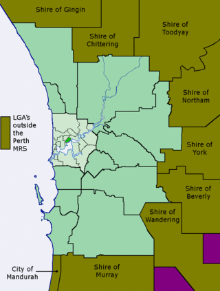
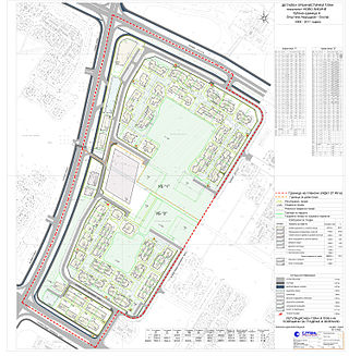
The Metropolitan Region Scheme (MRS) provides the legal basis for land use planning within the Perth metropolitan region. It classifies land into broad zones and reservations and is administered by the Western Australian Planning Commission. It is one of three regional schemes in Western Australia. The MRS is updated via an ongoing process of amendments. Amendments to the MRS are typically informed by a series of strategic plans prepared by the Department of Planning, Lands and Heritage. Detailed land use planning within the area of the MRS is undertaken by local governments and other statutory authorities which prepare one or more local planning schemes within their administrative boundaries. Local plannings schemes must be consistent with the MRS and require the approval of the WAPC. The acquisition of land reserved under the MRS is funded by a hypothecated land tax called the Metropolitan Region Improvement Tax.
Activity centre is a term used in urban planning and design for a mixed-use urban area where there is a concentration of commercial and other land uses. For example, the central business districts of cities (CBD) are also known as “Central Activities Districts” (CAD) (also known as Downtown in North America or "Central Activities Zone" in the United Kingdom in recognition of the fact that commercial functions are not the only things that occur there. The term activity centre can also be used to designate an area for mixed-use development, whatever its current land use happens to be.
An urban planner is a professional who practices in the field of town planning, urban planning or city planning.

The regions of England, formerly known as the government office regions, are the highest tier of sub-national division in England. They were established in 1994 and follow the 1974–96 county borders. They are a continuation of the former 1940s standard regions which followed the 1889–1974 administrative county borders. Between 1994 and 2011, all nine regions had partly devolved functions; they no longer fulfil this role, continuing to be used for limited statistical purposes.
Generally, spatial development is linked to include all the techniques used by planners, geographers and other actors of decision making to facilitate integrated balanced development. Spatial planning for development has no territorial barrier, ranging across continents, regions, nations and local communities. Various forms of spatial development qualities have been attributed mainly by the Developed World, while the Developing World and Cameroon in particular, are still trying to integrate the formula into their system. As such, to understand better spatial development in Cameroon, a brief notion of the African context is necessary.

Urban planning in Australia has a significant role to play in ensuring the future sustainability of Australian cities. Australia is one of the most highly urbanised societies in the world. Continued population growth in Australian cities is placing increasing pressure on infrastructure, such as public transport and roadways, energy, air and water systems within the urban environment.
Strategic environmental assessment (SEA) is a systematic decision support process, aiming to ensure that environmental and possibly other sustainability aspects are considered effectively in policy, plan and program making. In this context, following Fischer (2007) SEA may be seen as:
Japanese land law is the law of real property in Japan. A nationwide city land law began in 1919. This was completely revised in more detail in 1968, focusing on City Planning Areas. The concept of zoning was introduced to all of Japan beginning with the Land-Use Law in 1974 ; this was later integrated into City Planning Areas. After 2011, a decentralisation policy delegated the power to create a land-use plan without needing approval from the central government.