
The River Avon is in the south of England, rising in Wiltshire, flowing through that county's city of Salisbury and then west Hampshire, before reaching the English Channel through Christchurch Harbour in the Bournemouth, Christchurch and Poole conurbation of Dorset.

Odstock is a village and civil parish 3 miles (4.8 km) south of Salisbury in Wiltshire, England. The parish includes the village of Nunton with its nearby hamlet of Bodenham. The parish is in the valley of the River Ebble, which joins the Hampshire Avon near Bodenham.

The Berkshire Downs are a range of chalk downland hills in southern England, part of the North Wessex Downs Area of Outstanding Natural Beauty. The Berkshire Downs are wholly within the traditional county of Berkshire, although split between the current ceremonial counties of Berkshire and Oxfordshire. The western parts of the downs are also known as the Lambourn Downs.

The North Wessex Downs Area of Outstanding Natural Beauty (AONB) is located in the English counties of Berkshire, Hampshire, Oxfordshire and Wiltshire. The name North Wessex Downs is not a traditional one, the area covered being better known by various overlapping local names, including the Berkshire Downs, the North Hampshire Downs, the White Horse Hills, the Lambourn Downs, the Marlborough Downs, the Vale of Pewsey and Savernake Forest.

Coombe Bissett is a village and civil parish in the English county of Wiltshire in the River Ebble valley, 3 miles (4.8 km) southwest of Salisbury on the A354 road that goes south towards Blandford Forum.

Salisbury is a constituency represented in the House of Commons of the UK Parliament since 2010 by John Glen of the Conservative Party. He is currently the Economic Secretary to the Treasury.

Chalk streams are rivers that rise from springs in landscapes with chalk bedrock. Since chalk is permeable, water percolates easily through the ground to the water table and chalk streams therefore receive little surface runoff. As a result, the water in the streams contains little organic matter and sediment and is generally very clear. The beds of the rivers are generally composed of clean, compacted gravel and flints, which are good spawning areas for Salmonidae fish species.

Alvediston is a small village and civil parish in Wiltshire, England, about 7 miles (11 km) east of Shaftesbury and 11 miles (18 km) southwest of Salisbury. The area is the source of the River Ebble and is within the Cranborne Chase and West Wiltshire Downs Area of Outstanding Natural Beauty.
Berwick St John is a village and civil parish in southwest Wiltshire, England, about 5 miles (8 km) east of Shaftesbury in Dorset.

Bishopstone is a village and civil parish in Wiltshire, in the Ebble valley, about 5.5 miles (9 km) south-west of Salisbury. The parish includes the small village of Croucheston south of the river and the hamlet of The Pitts.
Bowerchalke is a village and civil parish in Wiltshire, England, about 9 miles (14 km) southwest of Salisbury. It is in the south of Wiltshire, about 1 mile (1.6 km) from the county boundary with Dorset and 2 miles (3.2 km) from that with Hampshire. The parish includes the hamlets of Mead End, Misselfore and Woodminton.
Broad Chalke, sometimes spelled Broadchalke, Broad Chalk or Broadchalk, is a village and civil parish in Wiltshire, England, about 8 miles (13 km) west of the city of Salisbury. The civil parish includes the hamlets of Knapp, Mount Sorrel and Stoke Farthing.

Ebbesbourne Wake is a village and civil parish in Wiltshire, England, some 10 miles (16 km) south-west of Salisbury, near the head of the valley of the small River Ebble. The parish includes the hamlets of Fifield Bavant and West End.

The River Ebble is one of the five rivers of the English city of Salisbury. Rising at Alvediston to the west of the city, it joins the River Avon at Bodenham, near Nunton.

Bowerchalke Downs, is a 128.6 hectare biological Site of Special Scientific Interest in Wiltshire, notified in 1971. The downs encompass the entire southern outlook of the village of Bowerchalke in the Salisbury district of Wiltshire, England, and are adjacent to both the Hampshire and Dorset county boundaries. The Bowerchalke Downs are located within the Cranborne Chase and West Wiltshire Downs Area of Outstanding Natural Beauty and are part of the Southern England Chalk Formation.

Gallows Hill SSSI is a Site of Special Scientific Interest on the north side of the Ebble Valley in south Wiltshire, England. Its chalk grassland and scrub contain a number of animal and plant species that are nationally rare. The 27.8 hectares site was notified in 1965.

Fifield Bavant is a small village and former civil parish in Wiltshire, England, about 6 miles (10 km) southwest of Wilton, midway between Ebbesbourne Wake and Broad Chalke on the north bank of the River Ebble.

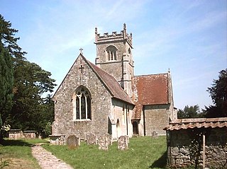
The Church of St Mary & St Lawrence in the village of Stratford Tony, Wiltshire, England, was built in the 13th century.

Dorset is a county located in the middle of the south coast of England. It lies between the latitudes 50.512°N and 51.081°N and the longitudes 1.682°W and 2.958°W, and occupies an area of 2,653 km². It spans 90 kilometres (56 mi) from east to west and 63 kilometres (39 mi) from north to south.
