River Og

Last updated

Og
River Og near Ogbourne St Andrew.jpg
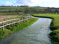
River Og, near Ogbourne St Andrew.
Location
Country England
County Wiltshire
Physical characteristics
Source 
  location Draycot Foliat, Swindon
  coordinates 51°29′53″N1°44′25″W / 51.49806°N 1.74028°W / 51.49806; -1.74028
Mouth  
  location
Marlborough
  coordinates
51°25′13″N1°43′43″W / 51.42028°N 1.72861°W / 51.42028; -1.72861
Length3.1 km (1.9 mi)

The River Og is a short river in Wiltshire, England.

It rises near the hamlet of Draycot Foliat, and flows south for about 3.1 km (1.9 miles) through Ogbourne St George, Ogbourne St Andrew and Ogbourne Maizey to the eastern edge of Marlborough, where it joins the River Kennet. [1]

The river flows through a gap in the Marlborough Downs, which creates a natural transport route, now followed by the A346 and once used by the Midland and South Western Junction Railway.

The Og's name is a back-formation from Ogbourne, which itself means Occa's stream. [2]

Related Research Articles

<span class="mw-page-title-main">Wiltshire</span> County of England

Wiltshire is a ceremonial county in South West England. It borders Gloucestershire to the north, Oxfordshire and Berkshire to the east, Hampshire to the south-east, Dorset to the south, and Somerset to the west. The largest settlement is Swindon and Trowbridge is the county town.

<span class="mw-page-title-main">River Kennet</span> Tributary of the River Thames in Southern England

The Kennet is a tributary of the River Thames in Southern England. Most of the river is straddled by the North Wessex Downs AONB. The lower reaches have been made navigable as the Kennet Navigation, which – together with the Avon Navigation, the Kennet and Avon Canal and the Thames – links the cities of Bristol and London.

<span class="mw-page-title-main">Marlborough, Wiltshire</span> Town and civil parish in Wiltshire, England

Marlborough is a market town and civil parish in the English county of Wiltshire on the Old Bath Road, the old main road from London to Bath. The town is on the River Kennet, 24 miles (39 km) north of Salisbury and 10 miles (16 km) southeast of Swindon.

<span class="mw-page-title-main">Aldbourne</span> Village in Wiltshire, England

Aldbourne is a village and civil parish about 6 miles (10 km) north-east of Marlborough, Wiltshire, England, in a valley on the south slope of the Lambourn Downs – part of the North Wessex Downs Area of Outstanding Natural Beauty. From here an unnamed winterbourne flows south to join the River Kennet 4 miles (6 km) away near Ramsbury. The 2011 Census recorded the parish population as 1,833. The parish includes the hamlets of Upper Upham and Woodsend and part of the hamlet of Preston, which straddles the boundary with Ramsbury. The village of Snap became deserted in the early 20th century.

<span class="mw-page-title-main">Mildenhall, Wiltshire</span> Human settlement in England

Mildenhall is a village and civil parish in the Kennet Valley in Wiltshire, England, immediately east of the market town of Marlborough. The village is about 1.5 miles (2 km) east of the centre of Marlborough, on the minor road which follows the River Kennet towards Ramsbury. The parish also contains the hamlets of Poulton and Stitchcombe. The name has often been written as Minal, and this is continued in the present-day pronunciation.

The geology of Shropshire is very diverse with a large number of periods being represented at outcrop. The bedrock consists principally of sedimentary rocks of Palaeozoic and Mesozoic age, surrounding restricted areas of Precambrian metasedimentary and metavolcanic rocks. The county hosts in its Quaternary deposits and landforms, a significant record of recent glaciation. The exploitation of the Coal Measures and other Carboniferous age strata in the Ironbridge area made it one of the birthplaces of the Industrial Revolution. There is also a large amount of mineral wealth in the county, including lead and baryte. Quarrying is still active, with limestone for cement manufacture and concrete aggregate, sandstone, greywacke and dolerite for road aggregate, and sand and gravel for aggregate and drainage filters. Groundwater is an equally important economic resource.

<span class="mw-page-title-main">Wiltshire Victoria County History</span> Encyclopaedic history of the county of Wiltshire in England

The Wiltshire Victoria County History, properly called The Victoria History of the County of Wiltshire but commonly referred to as VCH Wiltshire, is an encyclopaedic history of the county of Wiltshire in England. It forms part of the overall Victoria County History of England founded in 1899 in honour of Queen Victoria. With eighteen volumes published in the series, it is now the most substantial of the Victoria County Histories.

<span class="mw-page-title-main">Ogbourne St George</span> Human settlement in England

Ogbourne St George is a village and civil parish on the River Og about 3 miles (4.8 km) north of Marlborough, Wiltshire, England.

<span class="mw-page-title-main">Ogbourne St Andrew</span> Human settlement in England

Ogbourne St Andrew is a civil parish and small village in Wiltshire, England, 2 miles (3.2 km) north of Marlborough. The parish is on the banks of the River Og and includes the hamlets of Ogbourne Maizey and Rockley.

<span class="mw-page-title-main">Draycot Foliat</span> Human settlement in England

Draycot Foliat is a hamlet in Wiltshire, England, on the back road between Chiseldon to the north and Ogbourne St. George to the south. The nearest major town is Swindon which is about 5 miles (8 km) north. A notable feature is the small airstrip with its model helicopter instruction centre. There is one smallholding, called Draycot Farm, and a larger farm, Sheppard's Farm, which comprises some 750 acres. Attached to Sheppard's Farm is a small set of industrial buildings, most notably the Intellectual Property Law offices of Berry Davies LLP. In addition, there are between ten and twenty other houses. The Og, a tributary of the River Kennet, flows for about half of the year down the centre of the hamlet, forcing the road into a sharp hairpin bend.

<span class="mw-page-title-main">Ogbourne railway station</span> Former railway station in Wiltshire, England

Ogbourne railway station was on the Midland and South Western Junction Railway in Wiltshire, England. The station opened on 27 July 1881 on the Swindon Town to Marlborough section of the Swindon, Marlborough and Andover Railway. In 1883, a northwards extension, the Swindon and Cheltenham Extension Railway, opened from Swindon Town to Cirencester Watermoor, with further northward extension to a junction with the Great Western Railway's Cheltenham to Banbury line near Andoversford opening in 1891, enabling through trains from the Midlands to the south, through Ogbourne. The SM&AR and the S&CER had in 1884 amalgamated to form the M&SWJR.

<span class="mw-page-title-main">Ogbourne Maizey</span> Human settlement in England

Ogbourne Maizey is a hamlet in Wiltshire, England 1.6 miles (2.6 km) north of the town of Marlborough and 0.4 miles (0.64 km) south of the village of Ogbourne St. Andrew.

<span class="mw-page-title-main">Obadiah Sedgwick</span> English clergyman

Obadiah Sedgwick (1600?–1658) was an English clergyman of presbyterian views, and a member of the Westminster Assembly.

<span class="mw-page-title-main">Ridgeway Benefice</span> Group of parishes in Wiltshire, England

The Ridgeway Benefice is a group of parishes in Wiltshire, England, to the north of Marlborough.

<span class="mw-page-title-main">Cousins River</span> River in the United States

The Cousins River is a 4.7-mile-long (7.6 km), primarily tidal river in southern Maine. Rising in the town of Freeport at the junction of Harvey Brook and Merrill Brook, it flows south and forms, for most of its course, the boundary between Freeport and Yarmouth. It flows into the Royal River just west of its mouth in Casco Bay.

Ogbourne Priory was a priory in Wiltshire, England, from the 12th century until the early 15th.

<span class="mw-page-title-main">Marlborough White Horse</span>

Marlborough White Horse, also called the Preshute White Horse, is a hill figure on Granham Hill, a fairly shallow slope of the downland above the hamlet of Preshute, southwest of Marlborough in the county of Wiltshire, England. Dating from 1804, it is one of several such white horses to be seen around Great Britain, and one of nine in Wiltshire.

References

  1. "River Og". Catchment Data Explorer. Environment Agency. Retrieved 19 December 2022.
  2. Glover, J.E.B., Mawer, A. and Stenton, F.M. (1939) Place-names of Wiltshire, p.9