
The River Hamble is located in south Hampshire, England. It rises near Bishop's Waltham and flows for 10.1 km (6.3 mi) through Botley, Bursledon, and Lower Swanwick before entering Southampton Water between Hamble Common and Warsash.

The River Pang is a small chalk stream river in the west of the English county of Berkshire, and a tributary of the River Thames. It runs for approximately 23 kilometres (14 mi) from its source near the village of Compton to its confluence with the Thames in the village of Pangbourne.

The Beaulieu River, formerly known as the River Exe, is a small river draining much of the central New Forest in Hampshire, southern England. The river has many small upper branches and its farthest source is 8 miles (13 km) from its 4 miles (6 km)-long tidal estuary. Unusually, the river, including its bed, is owned by Lord Montagu of Beaulieu.

Foudry Brook is a small stream in southern England. It rises from a number of springs near the Hampshire village of Baughurst, and flows to the east and then the north, to join the River Kennet to the south of Reading. The upper section is called Silchester Brook, and beyond that, Bishop's Wood Stream. The underlying geology is chalk, covered by a layer of clay, and so it has the characteristics of a clay stream, experiencing rapid increases in level after heavy rain due to run-off from the surrounding land. It passes a number of listed buildings and scheduled monuments, including the site of the Roman town of Calleva Atrebatum or Silchester.

The River Frome, once also known as the Stroudwater, is a small river in Gloucestershire, England. It is to be distinguished from another River Frome in Gloucestershire, the Bristol Frome, and the nearby River Frome, Herefordshire. The river is approximately 25 miles (40 km) long.

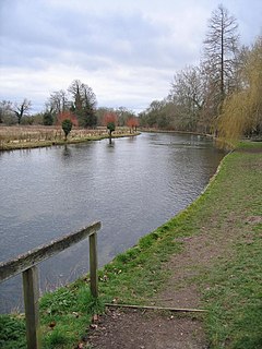
The River Wylye is a southern England chalk stream, with clear water flowing over gravel. It is popular with anglers for fly fishing. A half-mile stretch of the river and three lakes in Warminster are a local nature reserve.

This River Blackwater drains small parts of the English counties of Hampshire and Wiltshire. It is a tributary of the River Test.
The River Anton is a chalk stream in Hampshire in south east England. It rises in Andover and flows southwards for approximately 8 miles (13 km) to meet the River Test near Chilbolton. The principal tributary of the Anton, the Pillhill Brook, joins the river at Upper Clatford.

The River Dever is a chalk stream in Hampshire in the south of England. It rises at West Stratton near Micheldever and flows westwards for 11 mi (18 km) to meet the River Test at Wherwell.

The River Alre is a tributary of the River Itchen in Hampshire in the south of England. It rises in Bishop's Sutton and flows west for 6 km (3.7 mi) to meet the Itchen below New Alresford.
The River Nadder is a tributary of the River Avon, flowing in south Wiltshire, England.

The River Doe Lea is a river which flows near Glapwell and Doe Lea in Derbyshire, England. The river eventually joins the River Rother near Renishaw. The river contained 1,000 times the safe level of dioxins in 1991, according to a statement made by Dennis Skinner, (MP) in the House of Commons in 1992. The river flows through the site of the former Coalite plant near Bolsover, where coke, tar and industrial chemicals were manufactured until the plant closed in 2004.

The River Wey is a tributary of the River Thames in south east England. Its two branches, one of which rises near Alton in Hampshire and the other in West Sussex to the south of Haslemere, join at Tilford in Surrey. Once combined the flow is eastwards then northwards via Godalming and Guildford to meet the Thames at Weybridge. Downstream the river forms the backdrop to Newark Priory and Brooklands. The Wey and Godalming Navigations were built in the 17th and 18th centuries, to create a navigable route from Godalming to the Thames.
The Cut is a river in England that rises in North Ascot, Berkshire. It flows for around 14 miles (23 km), through the rural Northern Parishes of Winkfield, Warfield and Binfield in Bracknell Forest on its way down to Bray, where it meets the River Thames just above Queens Eyot on the reach below Bray Lock, having been joined by the Maidenhead Waterways.

Burghfield Brook is a small stream in southern England. It rises in Wokefield Common between the Berkshire villages of Mortimer and Burghfield Common. It is a tributary of Foudry Brook, which it joins near Hartley Court Farm, just to the south of the M4 motorway.

West End Brook is a small stream in southern England. It rises near the Hampshire village of Tadley. Its name is probably related to the parish, and village, it passes through for some of its course: Mortimer West End.

The River Dove is a river that extends through the Low Valley in Barnsley, England. It flows from Worsbrough Reservoir to its confluence with the River Dearne.

The River Hart is a tributary of the River Whitewater in north Hampshire, England. It rises at Ashley Head spring in Crondall and flows north to meet the Whitewater at Bramshill.

Bow Brook is a small river in the English county of Hampshire, which is a tributary of the River Loddon. Contributary streams rise near Ramsdell and Sherborne St John, and after flowing through rural countryside, it joins the Loddon near Sherfield on Loddon. Historically is has powered at least two watermills.

Fleet Brook is a small river in northern Hampshire, England and tributary of the River Hart.
