The A40 is a major road which runs between London and Goodwick (Fishguard), Wales, and officially called The London to Fishguard Trunk Road (A40) in all legal documents and Acts. Much of its length within England has been superseded by motorways, such as the M4 and M40, and has lost its trunk road status, though it retains it west of Gloucester, including its length within Wales. It is approximately 260 miles (420 km) long. The eastern section from Denham, Buckinghamshire to Wheatley, Oxfordshire is better served by the M40 and its former function of linking London with Cheltenham and Gloucester has been taken by the M4, A419 and A417 via Swindon.

The Mancunian Way is a two mile long grade separated elevated motorway in Manchester, England. It is officially made up of the A57(M) and A635(M) motorways, although the latter does not appear on road signs for practical reasons. It is also part of two other roads: the A57 to the west, which runs east–west through Greater Manchester linking the M602 and M67 motorways, and a short section of non-motorway A635 to the east. Part of this non-motorway section collapsed on 14 August 2015 due to a sinkhole.

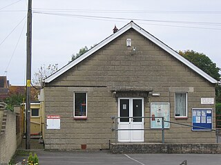
Melksham Without is a civil parish in the county of Wiltshire, England. It surrounds, but does not include, the town of Melksham and is the largest rural parish in Wiltshire, with a population of 7,230 and an area of 29 square kilometres.

The A350 is a north-south primary route in southern England, that runs from the M4 motorway in Wiltshire to Poole in Dorset.
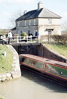
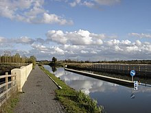
The Semington Locks are situated at Semington, Wiltshire on the Kennet and Avon Canal, England.
Semington is a village and civil parish in Wiltshire, England. The village is about 2 miles (3 km) south of Melksham and about 3 miles (5 km) northeast of Trowbridge. The parish includes the hamlets of Little Marsh and Littleton.
The BCN Main Line, or Birmingham Canal Navigations Main Line describes the evolving route of the Birmingham Canal between Birmingham and Wolverhampton in England.

The Lower Prospect Canal Reserve is a heritage-listed former farm and public water supply canal and now bushy corridor and nature reserve stretching 7.7 kilometres (4.8 mi) through the heart of suburban Sydney, New South Wales, Australia. The lineal corridor stretches from Prospect Reservoir to Sydney Water Pipehead at Albert Street, Guildford with the majority of the reserve located in Greystanes, which is a suburb within the Cumberland Council area.

The Lune Aqueduct is a navigable aqueduct that carries the Lancaster Canal over the River Lune, on the east side of the city of Lancaster in Lancashire, England. It was completed in 1797 at a total cost of £48,320 18s 10d. It is a Grade I listed building.
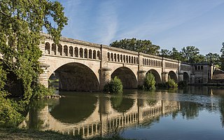
The Orb Aqueduct is a bridge which carries the Canal du Midi over the Orb in the city of Béziers in Languedoc, France. The aqueduct is 28 metres (92 ft) wide, 12 metres (39 ft) tall and at 240 metres (790 ft) is the longest on the Canal du Midi.

The M18 motorway is an inter-urban motorway in Ireland, forming part of the Limerick, Ennis to Galway national primary road, which, in turn, forms part of the Atlantic Corridor called for as part of the Transport 21 project.

Barton Road Swing Bridge is a swing bridge for road traffic in Greater Manchester that crosses the Manchester Ship Canal between Trafford Park in the Metropolitan Borough of Trafford to Barton-upon-Irwell in the City of Salford. The bridge is a Grade II listed building, and is part of a surrounding conservation area. It runs parallel to the Barton Swing Aqueduct which carries the Bridgewater Canal. The bridge opens regularly for traffic along the Manchester Ship Canal, which can cause delays for road traffic.

Clackline Bridge is a road bridge in Clackline, Western Australia, 77 kilometres (48 mi) east of Perth in the Shire of Northam, that carried the Great Eastern Highway until 2008. It is the only bridge in Western Australia to have spanned both a waterway and railway, the Clackline Brook and the former Eastern Railway alignment. The mainly timber bridge has a unique curved and sloped design, due to the difficult topography and the route of the former railway. The bridge was designed in 1934 to replace two dangerous rail crossings and a rudimentary water crossing. Construction began in January 1935, and was completed relatively quickly, with the opening ceremony held in August 1935. The bridge has undergone various improvement and maintenance works since then, including widening by three metres (10 ft) in 1959–60, but remained a safety hazard, with increasing severity and numbers of accidents through the 1970s and 1980s. Planning for a highway bypass of Clackline and the Clackline Bridge began in the 1990s, and it was constructed between January 2007 and February 2008. The local community had been concerned that the historic bridge would be lost, but it remains in use as part of the local road network, and has been listed on both the Northam Municipal Heritage Inventory and the Heritage Council of Western Australia's Register of Heritage Places.

The Upper Canal System, also called the Southern Railway Aqueduct and the Cataract Tunnel, is a heritage-listed operational gravity-fed aqueduct that supplies some of the potable water for Sydney, in New South Wales, Australia. The aqueduct comprises 54 kilometres (34 mi) of open canals, tunnels, and closed pipelines that connect the Upper Nepean Scheme with the Prospect Reservoir. The aqueduct is managed by the Sydney Catchment Authority on behalf of WaterNSW, an agency of the Government of New South Wales. It was listed on the New South Wales State Heritage Register on 18 November 1999.

The Boothtown Aqueduct is a heritage-listed 19th-century water bridge in Greystanes, Sydney, New South Wales, Australia. Established in 1888, the aqueduct was built to cross a valley to carry water from Prospect Reservoir to residents of Greater Western Sydney.

Lewisham Sewage Aqueduct is a heritage-listed sewage aqueduct in Gadigal Reserve, adjacent to 5 Grosvenor Crescent, Summer Hill, Inner West Council, Sydney, New South Wales, Australia. It was designed by Sewerage Construction Branch and Department of Public Works and built in 1900. The property is owned by Sydney Water. It was added to the New South Wales State Heritage Register on 18 November 1999.

The Cooks River Sewage Aqueduct is a heritage-listed sewage aqueduct located at Pine Street, Earlwood, New South Wales, Australia. It crosses the Cooks River to Thornley Street, Marrickville. It was designed by Sewerage Construction Branch and NSW Department of Public Works and built during 1895 by J. F. Carson, contractor. The property is owned by Sydney Water, an agency of the Government of New South Wales. It was added to the New South Wales State Heritage Register on 18 November 1999.

The Wolli Creek Aqueduct is a heritage-listed sewage aqueduct located at Unwin Street, Earlwood, City of Canterbury-Bankstown, New South Wales, Australia. It crosses Wolli Creek to Thompson Street, Turella. It was designed by Public Works Department and built in 1895 by the NSW Public Works Department. The property is owned by Sydney Water, an agency of the Government of New South Wales. It was added to the New South Wales State Heritage Register on 18 November 1999.

The Mosman Bay Sewage Aqueduct is a heritage-listed public pedestrian bridge and sewage aqueduct at Avenue Road, Mosman in the Mosman Council local government area of New South Wales, Australia. It was designed by Sewerage Construction Branch and NSW Department of Public Works and built from 1899 to 1901 by NSW Department of Public Works. It is also known as the Aqueduct over Mosman's Bay. The property is owned by Sydney Water, an agency of the Government of New South Wales. It was added to the New South Wales State Heritage Register on 18 November 1999.

White's Creek Aqueduct is a heritage-listed sewage aqueduct at Piper Street, Lilyfield, Inner West Council, Sydney, New South Wales, Australia. It was designed by engineer William Julius Baltzer of the New South Wales Public Works Department and built by the Department from 1897 to 1898. The property is owned by Sydney Water. It was added to the New South Wales State Heritage Register on 18 November 1999.