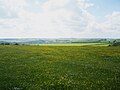
The Berkshire Downs are a range of chalkdownland hills in southern England, part of the North Wessex DownsArea of Outstanding Natural Beauty. The Berkshire Downs are wholly within the traditional county of Berkshire, although split between the current ceremonial counties of Berkshire and Oxfordshire. The western parts of the downs are also known as the Lambourn Downs.
The Berkshire Downs run east–west, with their scarp slope facing north into the Vale of White Horse and their dip slope bounded by the course of the River Kennet. Geologically they are continuous with the Marlborough Downs to the west and the Chilterns to the east. In the east they are divided from the Chilterns by Goring Gap on the River Thames. In the west their boundary is generally taken to be the border between Berkshire and Wiltshire, although the downs in Wiltshire between the Berkshire border and the valley of the River Og are sometimes considered to be part of the Berkshire Downs. The Berkshire and Marlborough Downs together form one of Natural England's National Character Areas.[1]
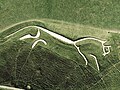
It is generally thought that in Anglo-Saxon times the downs were known as Æscesdūn or Ashdown, and that it was here that the Battle of Ashdown was fought in 871.[2]
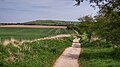
By the middle ages, the downs were famous for their huge flocks of sheep, providing wool and fertiliser for the lower-lying arable land with their manure to support the local corn production. From the 15th and 16th centuries, the downs saw the rise of a new type of large-scale, capitalist farming. Farmers began to expand their landholdings by taking over large institutional estates and absorbing smaller farms, leading to the creation of some of the country's largest farms. This trend of farm enlargement continued from the late 18th century and again after 1950, resulting in some exceptionally large farmsteads that stand out even in a national context. The average farm size in this area is now larger than in other chalk downland landscapes.[3]
Downland pasture is firm and well drained, suited to grazing sheep and grazing and training horses. Starting in the 19th century, horse racing became a major business in the area, with much of the downs covered with training areas, and stables centred on the village of Lambourn.
This page is based on this Wikipedia article Text is available under the CC BY-SA 4.0 license; additional terms may apply. Images, videos and audio are available under their respective licenses.