Wealdway

Last updated

Contents

The Wealdway, Kent and East Sussex, is a public footpath that runs for 83 miles / 134 km from Gravesend, Kent on the Thames estuary, to the A259 at Eastbourne, 3 km north of Beachy Head. [2]

Interrelation with other long-distance routes

This is the only north-south route from the Thames Estuary east of London and west of the Medway Towns. It crosses the North Downs, Higher and Lower, Kentish and Sussex Weald (see Kent long distance walks here) and starts at Gravesend. Here there is a regular ferry link to Tilbury and routes north of the Thames. At the south is Eastbourne the start of the South Downs Way overlooking the south coast. The route provides access to coast routes: a return circuit for users of the Saxon Shore Way.

History

The Wealdway, and the other Kent long-distance footpaths. Kent Long Distance Footpaths.png
The Wealdway, and the other Kent long-distance footpaths.

The Wealdway was conceived in 1970 by members of the Ramblers' Association. The first route descriptions were published in the mid seventies, but the poor state of the rights of way between Uckfield and Eastbourne delayed publication until 1981. Motorway Construction work and the building of the Tonbridge Flood Relief Barrier forced many changes to the original route.
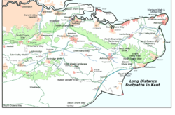
Route

The Geology of the Weald Kent East Sussex Downs.svg
The Geology of the Weald

From the Thames Estuary

The route goes through Gravesend; crosses the A2 at Tollgate; goes southward through Sole Street and Luddesdown; climbs to the North Downs Way at Trottiscliffe/Vigo Village; descends the scarp slope of the North Downs; crosses the M20 and A20; goes through Platt and Mereworth Woods to Gover Hill, where the Medway valley comes into view; goes down to West Peckham, Barnes Street and thus to the Medway; takes the riverside path upstream for a full 6 miles (9.7 km), through Tonbridge to Hayesden; heads due south, under the railway and under the Tonbridge bypass; climbs to the ridge at Bidborough through to Modest Corner, Southborough; and follows a mixture of paths and roads to the A264, at Stone Cross.

From the Kent borders

The route crosses into Sussex, following the medium height contours; drops down into the upper Medway valley wending its way to Withyham; follows a metalled drive, with good views to the north and south, leading to Five Hundred Acre Wood, the inspiration for A. A. Milne's, Christopher Robin and Winnie the Pooh books – the wood was first enclosed in 1693 and the path dedicated as a right of way by the owner in 1970; rises to Greenwood Gate Clump, at the top of the Ashdown Forest 720 ft (220 m) above mean sea level; continues on high ground to Camp Hill and on to Browns Brook Cottage; progresses to Buxted Park, Uckfield; rounds Blackboys, with its Youth Hostel; traverses East Hoathly and Chiddingly; negotiates Gun Hill walking through arable and pasture interspersed with coppice; descends into the Cuckmere valley at Hellingly through to the A22 south of Horsebridge; passes through Upper Dicker; crosses the River Cuckmere to get to Arlington; passes Wilmington and its 226 ft (69 m) high chalk figure, the Long Man; climbs then falls towards Jevington; climbs to Willingdon Hill, 659 ft (201 m); journeys 2 miles (3.2 km) downhill to the Eastbourne Youth Hostel on the A259 and optionally continues along the footway to the resort itself.

Commons-logo.svg Media related to Wealdway at Wikimedia Commons

Related Research Articles

East Sussex County of England

East Sussex is a non metropolitan county in South East England on the English Channel coast. It is bordered by the non metropolitan counties of Kent to the north and east, West Sussex to the west, and Surrey for a short distance to the north-west.

River Medway River in South East England

The River Medway is a river in South East England. It rises in the High Weald, East Sussex and flows through Tonbridge, Maidstone and the Medway conurbation in Kent, before emptying into the Thames Estuary near Sheerness, a total distance of 70 miles (113 km). About 13 miles (21 km) of the river lies in East Sussex, with the remainder being in Kent.

South Downs Way

The South Downs Way is a long distance footpath and bridleway running along the South Downs in southern England. It is one of 16 National Trails in England and Wales. The trail runs for 160 km (100 mi) from Winchester in Hampshire to Eastbourne in East Sussex, with about 4,150 m (13,620 ft) of ascent and descent.

A2 road (England) Road in southern England

The A2 is a major road in south-east England, connecting London with the English Channel port of Dover in Kent. This route has always been of importance as a connection between London and sea trade routes to Continental Europe. It was originally known as the Dover Road. The M2 motorway has replaced part of the A2 as the strategic route.

South Downs Range of chalk hills in southeast England

The South Downs are a range of chalk hills that extends for about 260 square miles (670 km2) across the south-eastern coastal counties of England from the Itchen valley of Hampshire in the west to Beachy Head, in the Eastbourne Downland Estate, East Sussex, in the east. The Downs are bounded on the northern side by a steep escarpment, from whose crest there are extensive views northwards across the Weald. The South Downs National Park forms a much larger area than the chalk range of the South Downs and includes large parts of the Weald.

Wealden District District in East Sussex, England

Wealden is a local government district in East Sussex, England. Its council is based in Hailsham. The district's name comes from the Weald, the remnant forest which was once unbroken and occupies much of the centre and north of the area.

Tonbridge and Malling Non-metropolitan district in England

Tonbridge and Malling is a local government district with borough status in Kent, England. Tonbridge is the largest settlement but the authority is based in the modern development of Kings Hill.

A21 road (England)

For other roads with the same name see List of A21 roads.

Monarchs Way Long-distance footpath in England

The Monarch's Way is a 625-mile (1,006 km) long-distance footpath in England that approximates the escape route taken by King Charles II in 1651 after being defeated in the Battle of Worcester. It runs from Worcester via Bristol and Yeovil to Shoreham, West Sussex.

The Vanguard Way is a long-distance walk of 66.2 mi (106.5 km) from East Croydon station in outer London, travelling from the north, to Newhaven, on the south coast of England. It passes through the counties of Surrey, Kent and East Sussex, between Croydon and Newhaven, East Sussex. It connects the London suburbs to the south coast, via the North Downs, Ashdown Forest, South Downs National Park and the Cuckmere valley.

Saxon Shore Way Long-distance footpath in England

The Saxon Shore Way is a long-distance footpath in England. It starts at Gravesend, Kent, and traces the coast of South-East England as it was in Roman times as far as Hastings, East Sussex, 163 miles (262 km) in total. This means that around Romney Marsh the route runs significantly inland from the modern coastline.

Redhill–Tonbridge line

The Redhill–Tonbridge line is a railway line in South East England that links Redhill, Surrey with Tonbridge, Kent.

The following are lists of recreational walks in East Sussex, England

The following is a list of recreational walks in Kent, England.

Transportation needs within the county of Kent in South East England has been served by both historical and current transport systems.

Geography of Kent Overview of the geography of Kent

Kent is the south-easternmost county in England. It is bounded on the north by the River Thames and the North Sea, and on the south by the Straits of Dover and the English Channel. The continent of Europe is 21 miles across the straits.

National Cycle Route 1 Route of the National Cycle Network in the UK

National Cycle Route 1 is a route of the National Cycle Network, running from Dover to Tain. The 1,022 km-long (635-mile) cycle-path is located in the United Kingdom.

Sussex Border Path Long-distance footpath following borders of Sussex, England

The Sussex Border Path is a long-distance footpath around the borders of Sussex, a historic county and former medieval kingdom in southern England. The main path is 150 miles (240 km) long and stays close to Sussex's borders with Hampshire, Surrey and Kent, connecting Thorney Island to Rye. There is also an additional 33-mile (53 km) spur known as the Mid Sussex Link, which links East Grinstead with Fishersgate and Mile Oak on the western boundary of the city of Brighton and Hove.

High Weald Landscape Trail

The High Weald Landscape Trail (HWLT) is a 145-kilometre (90 mi) route in England between Horsham, West Sussex and Rye, East Sussex, designed to pass through the main landscape types of the High Weald Area of Outstanding Natural Beauty (AONB). It does not follow the highest ground, and the eastern section is only a few feet above sea level. It keeps to the northern edge of the High Weald except in the west where it runs close to the southern edge for a short distance.

The geology of Kent in southeast England largely consists of a succession of northward dipping late Mesozoic and Cenozoic sedimentary rocks overlain by a suite of unconsolidated deposits of more recent origin.

References

  1. The Wealdway, 1981, pub. Wealdway Steering Group
  2. The Wealdway 80 miles long distance footpath, 1981, pub Wealdway Steering Group.