Brighton is a seaside resort and one of the two main areas of the city of Brighton and Hove in the county of East Sussex, England. It is located 47 miles (76 km) south of London. Archaeological evidence of settlement in the area dates back to the Bronze Age, Roman and Anglo-Saxon periods. The ancient settlement of "Brighthelmstone" was documented in the Domesday Book (1086). The town's importance grew in the Middle Ages as the Old Town developed, but it languished in the early modern period, affected by foreign attacks, storms, a suffering economy and a declining population. Brighton began to attract more visitors following improved road transport to London and becoming a boarding point for boats travelling to France. The town also developed in popularity as a health resort for sea bathing as a purported cure for illnesses.

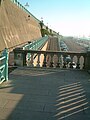
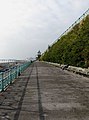
The West Pier is a ruined pier in Brighton, England. It was designed by Eugenius Birch and opened in 1866. It was the first pier to be Grade I listed in England but has become increasingly derelict since its closure to the public in 1975. As of 2024 only a partial metal framework remains.

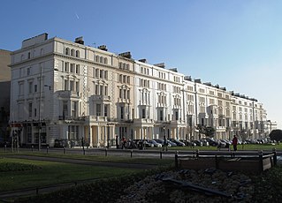
The Grand Brighton Hotel is a Victorian sea-front hotel in Brighton on the south coast of England. Designed by John Whichcord Jr. and built in 1864, it was intended for members of the upper classes visiting the town and remains one of Brighton's most expensive hotels.

Brighton i360 is a 162 m (531 ft) moving observation tower on the seafront of Brighton, East Sussex, England at the landward end of the remains of the West Pier. The tower opened on 4 August 2016. From the fully enclosed viewing pod, visitors experience 360-degree views across Brighton, the South Downs and the English Channel.
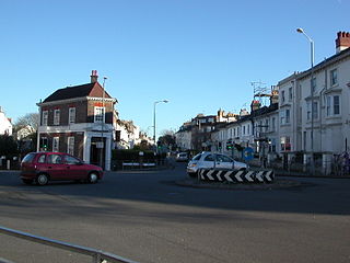
Seven Dials is a district surrounding a major road junction of the same name in Brighton, in the city of Brighton and Hove. It is located on high ground just northwest of Brighton railway station, south of the Prestonville area, and approximately ¾ mile north of the seafront.

Embassy Court is an 11-storey block of flats on the seafront in Brighton, part of the English city of Brighton and Hove. It has been listed at Grade II* by English Heritage. Wells Coates' "extremely controversial" piece of Modernist architecture has "divided opinion across the city" since its completion in 1935, and continues to generate strong feelings among residents, architectural historians and conservationists.

The Clock Tower is a free-standing clock tower in the centre of Brighton, part of the English city of Brighton and Hove. Built in 1888 in commemoration of the Golden Jubilee of Queen Victoria, the distinctive structure included innovative structural features and became a landmark in the popular and fashionable seaside resort. The city's residents "retain a nostalgic affection" for it, even though opinion is sharply divided as to the tower's architectural merit. English Heritage has listed the clock tower at Grade II for its architectural and historical importance.

Brighton and Hove, a city on the English Channel coast in southeast England, has a large and diverse stock of buildings "unrivalled architecturally" among the country's seaside resorts. The urban area, designated a city in 2000, is made up of the formerly separate towns of Brighton and Hove, nearby villages such as Portslade, Patcham and Rottingdean, and 20th-century estates such as Moulsecoomb and Mile Oak. The conurbation was first united in 1997 as a unitary authority and has a population of about 253,000. About half of the 20,430-acre (8,270 ha) geographical area is classed as built up.
Thomas Lainson, FRIBA was a British architect. He is best known for his work in the East Sussex coastal towns of Brighton and Hove, where several of his eclectic range of residential, commercial and religious buildings have been awarded listed status by English Heritage. Working alone or in partnership with two sons as Lainson & Sons, he designed buildings in a wide range of styles, from Neo-Byzantine to High Victorian Gothic; his work is described as having a "solid style, typical of the time".

Roundhill Crescent is a late-19th-century housing development in Round Hill, an inner suburb of the English coastal city of Brighton and Hove. Partly developed in the 1860s with large terraced houses on a steeply sloping open hillside, the crescent—which "curves and changes height dramatically along its length"—was finished two decades later and now forms the centrepiece of the Round Hill conservation area. Smaller houses completed the composition in the 1880s, and England's first hospital for the treatment of mental illness was founded in the crescent in 1905. The five original sets of houses from the 1860s have been listed at Grade II by English Heritage for their architectural and historical importance, and the crescent occupies a prominent place on Brighton's skyline.

The DoubleTree by Hilton Brighton Metropole is a 4-star hotel and conference centre located on the seafront in Brighton, East Sussex.

The Brighton Wheel, also known during its planning and construction phase as the Brighton O and the Wheel of Excellence, was a transportable Ferris wheel installation which operated from October 2011 until May 2016 on the seafront in Brighton, part of the English city of Brighton and Hove. Situated below the East Cliff near Brighton Pier and built with private funding, its promoters anticipated that several hundred thousand visitors per year would experience the 12-minute ride. The wheel's location in a conservation area with many residential buildings proved controversial.

Montpelier is an inner suburban area of Brighton, part of the English city and seaside resort of Brighton and Hove. Developed together with the adjacent Clifton Hill area in the mid-19th century, it forms a high-class, architecturally cohesive residential district with "an exceptionally complete character". Stucco-clad terraced housing and villas predominate, but two of the city's most significant Victorian churches and a landmark hospital building are also in the area, which lies immediately northwest of Brighton city centre and spreads as far as the ancient parish boundary with Hove.
Montpelier Crescent is a mid 19th-century crescent of 38 houses in the Montpelier suburb of the English coastal city of Brighton and Hove. Built in five parts as a set-piece residential development in the rapidly growing seaside resort, the main part of the crescent was designed between 1843 and 1847 by prominent local architect Amon Henry Wilds and is one of his most distinctive compositions. Extra houses were added at both ends of the crescent in the mid-1850s. Unlike most other squares, terraces and crescents in Brighton, it does not face the sea—and the view it originally had towards the South Downs was blocked within a few years by a tall terrace of houses opposite. Montpelier was an exclusive and "salubrious" area of Brighton, and Montpelier Crescent has been called its "great showpiece". Wilds's central section has been protected as Grade II* listed, with the later additions listed separately at the lower Grade II. The crescent is in one of the city's 34 conservation areas, and forms one of several "outstanding examples of late Regency architecture" within it.
The Anthaeum was an iron and glass conservatory planned by English botanist and landscape gardener Henry Phillips and designed by architect Amon Henry Wilds on land owned by Sir Isaac Goldsmid in Hove, a Sussex seaside town which is now part of the city of Brighton and Hove. Conceived on a grand scale and consisting of a gigantic cupola-topped dome covering more than 1.5 acres (0.61 ha), the structure was intended to enclose a carefully landscaped tropical garden, with exotic trees and shrubs, lakes, rockeries and other attractions. The scheme was a larger and more ambitious version of a project Phillips and Wilds had worked on in 1825 in Hove's larger neighbour Brighton, for which money had run out before work could commence. Unlike its predecessor, the Anthaeum was built: work began in 1832 and an opening ceremony was planned for 31 August 1833. Disagreements between the architect, the project engineer and the building contractor led to structural problems being overlooked or ignored, though, and the day before it opened the Anthaeum collapsed spectacularly. Its wreckage stayed for nearly 20 years overlooking Adelaide Crescent, a seafront residential set-piece whose northern side it adjoined, and Phillips went blind from the shock of watching the largest of his many projects end in disaster. Palmeira Square, another residential development, has occupied the site since the late 19th century.
Palmeira Square is a mid-19th-century residential development in Hove, part of the English city and seaside resort of Brighton and Hove. At the southern end it adjoins Adelaide Crescent, another architectural set-piece which leads down to the seafront; large terraced houses occupy its west and east sides, separated by a public garden; and at the north end is one of Hove's main road junctions. This is also called Palmeira Square, and its north side is lined with late 19th-century terraced mansions. Commercial buildings and a church also stand on the main road, which is served by Brighton & Hove bus routes 1, 1A, N1, 2, 5, 5A, 5B, N5, 6, 25, 46, 49, 60, 71, 71A and 96.

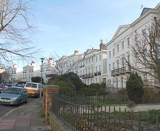
Adelaide Crescent is a mid-19th-century residential development in Hove, part of the English city and seaside resort of Brighton and Hove. Conceived as an ambitious attempt to rival the large, high-class Kemp Town estate east of Brighton, the crescent was not built to its original plan because time and money were insufficient. Nevertheless, together with its northerly neighbour Palmeira Square, it forms one of Hove's most important architectural set-pieces. Building work started in 1830 to the design of Decimus Burton. The adjacent land was originally occupied by "the world's largest conservatory", the Anthaeum; its collapse stopped construction of the crescent, which did not resume until the 1850s. The original design was modified and the crescent was eventually finished in the mid-1860s. Together with the Kemp Town and Brunswick Town estates, the crescent is one of the foremost pre-Victorian residential developments in the Brighton area: it has been claimed that "outside Bath, [they] have no superior in England". The buildings in the main part of Adelaide Crescent are Grade II* listed. Some of the associated buildings at the sea-facing south end are listed at the lower Grade II.

The Norfolk Hotel is a 4-star hotel in the seaside resort of Brighton, part of the English city of Brighton and Hove. Designed in 1865 by architect Horatio Nelson Goulty, it replaced an earlier building called the Norfolk Inn and is one of several large Victorian hotels along the seafront. The French Renaissance Revival-style building, recalling E.M. Barry's major London hotels, is "tall, to make a show": the development of the passenger lift a few years earlier allowed larger hotels to be built. It is a Grade II listed building.

SEA LIFE Brighton, known originally as Brighton Aquarium and then from 1969 until 1991 as Brighton Aquarium and Dolphinarium, is an aquarium attraction in Brighton, part of the English seaside city of Brighton and Hove. Opened as Brighton Aquarium in 1872, it is the oldest continuously operating aquarium in the world, and the main tank was the largest in the world at the time. The attraction was bought by SEA LIFE in 1991.