| Name | Size | Date | Notes | Refs |
|---|
| Benfield Barn, Hangleton | 1.43 acres (0.58 ha) | 1989 | The city's smallest conservation area includes a Grade II-listed barn—part of an ancient farm next to the former Benfield Manor house—and the four terraced cottages which replaced it. The red-brick and flint barn may be late-18th-century, and the houses were built in 1871 for farm workers. They are of yellow stock brick with slate-tiled roofs. | [33] |
| Brunswick Town, Hove | 95.92 acres (38.82 ha) | 1969 | Local architecture evolved into "serious Neoclassical" at this carefully planned and landscaped set-piece in the mid-1820s. Columns of various orders, pilasters and bow fronts characterise the square and its flanking terraces, all of which enjoy sea views and access to extensive lawns. Smaller squares and streets, such as Adelaide Crescent, Lansdowne Place and Palmeira Square, surround the centrepiece, and are slightly more modest in scope. Stuccoed façades, slate roofs, consistent building heights and long parapets contribute to the impression of regularity and formality. | [34] [35]
[36] [37] |
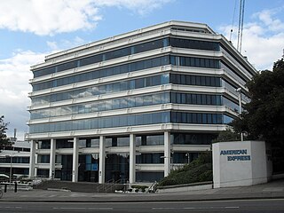
| Carlton Hill | 4.05 acres (1.64 ha) | 2008 | This early-19th-century working-class area was comprehensively redeveloped in the mid-20th century after degenerating into a slum, but a few old buildings remain: Tilbury Place is a good example of Georgian architecture, George Cheesman junior's severely Classical church dates from 1839, and the cobble-fronted Mighell Farmhouse survived when adjacent buildings were demolished for Amex House, a large office block. The area's character derives from these buildings, its site on a steep hill with long views, and the survival of fragments of old street layouts and boundary walls in places. | [18] [31]
[38] [39] |
| Cliftonville, Hove | 40.05 acres (16.21 ha) | 1969 | A small area of "delightful mid-Victorian houses", in a villa style with angled bay windows and exterior ironwork, this 1850s suburb is an example of the long-lasting influence of the Regency style on Victorian domestic architecture. The increasingly fashionable Italianate style is also evident. Slight differences can be seen between individual houses: plots were sold speculatively, so most houses were built to individuals' requirements. Sash windows with valances are characteristic features. | [10] [22]
[40] [41] |
| College Conservation Area | 18.60 acres (7.53 ha) | 1988 | The College Conservation Area in Brighton is a 7.53-hectare region that was designated as a conservation area in 1988. The conservation area has an approximately rectangular plan, bounded on the southwest by Eastern Road and the northwest by Sutherland Road and most of College Terrace and extending to Canning Street to the northeast and includes all of Walpole Road and Walpole Terrace to the southeast, as well as including the western end of Belle Vue Gardens. The area is home to a diverse community of residents, with a mix of prestigious semi-detached villas to the west and smaller artisan terraced houses closer to the station to the east. The conservation area is of architectural and historic interest, and the character and appearance of the area are preserved and enhanced. | [42] [43]
[44] [45]
[46] |
|---|
| Denmark Villas, Hove | 7.42 acres (3.00 ha) | 1984 | This road was a northern extension of Cliftonville, built on the way to Hove railway station (opened in 1865). The area has well-spaced Italianate houses in a more modestly detailed style than the rest of Cliftonville, with prominent architraves, quoins and eaves, yellow brickwork and mosaic tiled paths. The road is lined with mature trees, contributing to its character. | [10] [47] |
| East Cliff | 153.99 acres (62.32 ha) | 1973 | Hundreds of listed buildings, a strong and little changed street pattern and the prevalence of Regency architecture characterise the East Cliff, which developed from the late 18th century because of its proximity to the fashionable Old Steine. Many landowners held small plots, so cohesive large-scale developments were not possible; instead, streets tended to follow a north–south alignment defined by old field boundaries. The houses and hotels of Marine Parade, the east–west clifftop road (built from 1827 on the site of a trackway), present a long stuccoed façade which has been described as "unsurpassed anywhere in Britain". | [48] [49]
[50] |
| Engineerium, West Blatchington | 8.89 acres (3.60 ha) | 1982 | Built in 1866 as the Goldstone Pumping Station to provide more piped water for Brighton and Hove's rapidly growing population, this became a museum in 1976. Considered to be excellent examples of 19th-century industrial design, the brick buildings are intricately detailed with Classical motifs and multicoloured brickwork. The tall chimney is a significant landmark. | [26] [51] |
| Hangleton | 15.54 acres (6.29 ha) | 1984 | Hangleton became a postwar overspill estate, with what Pevsner called "a grisly set of parodies of the English cottage", but at the centre a set of ancient buildings remain around a park. St Helen's Church has changed little since the 11th century, and Hangleton Manor is Hove's oldest secular building. Now used as a restaurant, it retains its old dovecote and associated cottages. | [52] [53]
[54] [55] |
| Hove Station | 14.56 acres (5.89 ha) | 1996 | Built as Cliftonville in 1865, Hove railway station soon stimulated middle-class residential development. Goldstone Villas, a wide tree-lined avenue with terraced houses in various styles, was developed in the 1880s and 1890s. Brick in pale colours such as yellow, buff and brown predominates; slate roofs are also common, and many windows are canted bays. Some large-scale late-20th-century developments have affected the area. The Ralli Memorial Hall, a red brick and stone Renaissance-style building of 1913, and a Neoclassical former chapel of 1878 (now an office) provide variety. | [56] [57]
[58] |
| Kemp Town | 47.94 acres (19.40 ha) | 1970 | The estate has two sea-facing terraces (Arundel and Chichester Terrace) linked to a three-sided square (Sussex Square) by Lewes Crescent, an 840-foot (260 m) double curve of 28 stuccoed houses with large Corinthian pilasters at regular intervals. Charles Busby's original designs were followed most closely in the crescent; the 300-by-550-foot (91 m × 168 m) square took longer to complete and diverges from his plan. Chichester Terrace was finished only in 1855. Thomas Cubitt built 37 of the estate's 106 houses. Surrounding mews and backstreets, the private gardens at the centre, original street furniture and the seafront esplanade (by Henry Kendall) are included in the conservation area. | [14] [59]
[60] [61] |
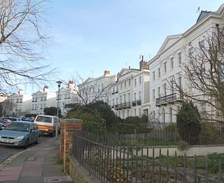
| Montpelier & Clifton Hill | 75.40 acres (30.51 ha) | 1973 | Clifton Hill rises gently to a summit between the old town centre and West Hill. Built up from the 1820s to the 1860s, the southwest-facing slopes became Brighton's most desirable suburb. Regency and Italianate architecture dominate the area, and many buildings are stuccoed. St Nicholas' Church, Brighton's ancient parish church, is in the area, and is one of hundreds of listed buildings. Other listed churches include St Michael and All Angels, whose interior is considered the best in England, and St Mary Magdalen, but the Gothic Christ Church burnt down in the 1970s and was replaced by International/Modern-style flats. | [62] [63]
[64] |
| North Laine | 41.37 acres (16.74 ha) | 1977 | Based around the east end of Church Street, the oldest road, this tightly packed residential and commercial area was developed in the late 18th and early 19th centuries, helped by Brighton railway station's proximity. A laine was an open field which was divided into strips (furlongs and paul-pieces) separated by pathways; pre-modern Brighton was surrounded by five, including North Laine. The boundaries defined the pattern of development: main roads (such as Church Street) follow the old paths, while side streets run at right-angles along the furlongs and paul-pieces. Total redevelopment was proposed in the 1960s, but the area survived; its "attractive townscape has a distinctive ambience" which makes it "the heart and soul of Brighton". | [65] [66]
[67] |
| Old Hove | 34.44 acres (13.94 ha) | 1997 | Hove Street—the ancient village street, whose manor house was demolished in the 1930s—and its surroundings make up this conservation area. Most housing is of the late 19th century: large, mostly semi-detached or terraced and built of red brick. St Andrew's, the former parish church (rebuilt in a Neo-Norman/Romanesque style by George Basevi in 1834) and Hove Public Library are both listed buildings. The former Connaught Road School, of brown and red brick with Dutch gables and terracotta dressings, adds further interest. | [68] [69] |
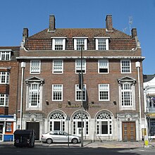
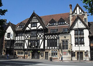
| Old Town | 46.77 acres (18.93 ha) | 1973 | The narrow, winding twittens known as The Lanes were built up in the 16th and 17th centuries as Brighton's fishing industry thrived. Most surviving buildings come from a second period of growth in the 18th and 19th centuries, as small houses were built for newly arrived workers. Many have been converted into small independent shops. Several old pubs, Thomas Lainson's Byzantine Revival Middle Street Synagogue (1875) and the Quaker meeting house (1805) are also in the area. | [70] [71]
[72] |
| Ovingdean | 48.58 acres (19.66 ha) | 1970 | Events in Harrison Ainsworth's novel Ovingdean Grange are fictional, but the building (formerly the manor house) exists in the centre of this downland village, inland from Rottingdean and 2.5 miles (4 km) east of Brighton. St Wulfran's Church, whose churchyard contains a memorial to the family of William Willett, is 12th-century. The adjacent rectory, Ovingdean Hall (a school until 2010) and many flint cottages, mostly of the 18th century, surround the village green and main street. | [29] [73]
[74] [75]
[76] |
| Patcham | 20.78 acres (8.41 ha) | 1970 | This ancient downland village was extensively suburbanised in the interwar period, but the core of the village—around All Saints Church—remains intact. One of Sussex's largest villages (and parishes) in the 11th century, the population declined by the 19th century; the conservation area's boundary match those of the village as it was from the 1870s until expansion began (as a result of its inclusion within the Borough of Brighton in 1928). Well-wooded parkland, especially around the Grade II*-listed Patcham Place, and access to the South Downs (affected by construction of the Brighton Bypass in the 1990s) contribute to the area's character. Many buildings are of flint or cobblestone; some have glazed black mathematical tiles. | [77] [78]
[79] [80]
[81] |
| Pembroke & Princes, Hove | 54.74 acres (22.15 ha) | 1989 | Most of this area consists of large late Victorian and early Edwardian houses built during Hove's westward expansion. There is also some later housing, mainly of the 1920s and 1930s. Large front gardens, wide curved tree-lined streets, tile-hung façades, painted exterior timbers and hipped roofs with gable ends characterise the area. Non-residential buildings of interest include the Italianate Brooker Hall, now a museum, and Barford Court—an unusual Neo-Georgian/Art Deco nursing home built of handmade purple bricks. | [82] [83] |
| Portslade Old Village | 34.21 acres (13.84 ha) | 1974 | Portslade sits in a valley west of Hove and has pre-medieval origins; the old village clusters around St Nicolas' Church and the ruined manor house. Pevsner thought that the combination of small flint-walled cottages and a huge Classical/Italianate brewery building of 1881 made it a "bizarre landscape". Extensive parkland, nearby woodland, extensive flint walling and some large 19th-century detached houses contribute to the area's character. Many buildings are listed. | [84] [85] |
| Preston Park | 214.47 acres (86.79 ha) | 1970 | This area consists of the extensive late-19th-century residential areas north and east of Preston Park: the park itself is part of the neighbouring Preston Village conservation area. Developed in a controlled, architecturally harmonious manner between 1865 and 1885, the long, straight streets of brick villas have features such as timbered gables, decorated bargeboards, canted bay windows and walls combining red brickwork and stucco. Two churches, including the Grade II-listed St Augustine's, contribute to the character of the area. | [86] [87]
[88] |
| Preston Village | 80.51 acres (32.58 ha) | 1970 | A small village with a manor house and church existed at the time of the Domesday survey in 1086, about 1.5 miles (2.4 km) north of Brighton. The manor (rebuilt in 1738) and church survive and form the centrepiece of this conservation area. Small, irregularly laid out flint cottages lie west of the main London Road, while the eclectic late-19th-century houses in Lovers Walk "form an important and attractive group". | [86] [89]
[90] |
| Queen's Park | 45.86 acres (18.56 ha) | 1977 | This large park east of Brighton was laid out in 1823 as Brighton Park. Town Clerk Thomas Attree bought it soon afterwards, rededicated it to Queen Adelaide and built a villa (demolished in the 1970s) on the edge. Some of its associated structures, such as the Pepper Pot tower, survive. Two triumphal archways, the Classical remains of a spa, a brick and stone clock tower and a terracotta-decorated pseudo-medieval drinking fountain are also found in the 15.3-acre (6.2 ha) park. | [91] [92]
|
| Regency Square | 79.69 acres (32.25 ha) | 1973 | Brighton expanded westwards from its historic centre in the early 19th century: developments such as Bedford (the earliest), Russell, Clarence and Regency Squares, Sillwood Place, Western Terrace and Cavendish Place were built for wealthy people attracted to the newly fashionable resort, and hotels (the Grand, Bedford and Norfolk) and entertainment venues followed. Pressure for new development in the 20th century introduced taller buildings such as Sussex Heights and Embassy Court—a Modernist contrast to the predominant stuccoed Regency architecture. | [93] [94]
[95]
[96] |
| Rottingdean | 41.64 acres (16.85 ha) | 1970 | This Saxon village, in a valley behind the seafront east of Brighton, grew rich on agriculture and smuggling, and has dozens of large old houses (especially from the 17th and 18th centuries) around a village green with a pond and church. Ancient trees, flint buildings and walls, old farmhouses and associated buildings characterise the village, but heavy traffic has affected its character for many decades. | [97] [98]
[99] [100] |
| Round Hill | 29.78 acres (12.05 ha) | 1977 | This hill rises to 223 feet (68 m) and offers long views in all directions. Its terraced streets and landmark buildings are also visible from many other parts of Brighton. The former Kemp Town branch line cut through the area; its former course is now green space which contributes to the area's character. The steep slopes and parallel roads at several levels make the "cat's-creep"—a long, narrow path in the form of a staircase between buildings—a distinctive feature. Most houses were built between the 1860s and the 1880s. | [30] [101]
[102] |
| Sackville Gardens, Hove | 32.40 acres (13.11 ha) | 1997 | Three long north–south streets, built on allotment land in the late 19th century, and adjacent buildings on the main east–west routes through Hove, make up this small conservation area. The mostly residential area was laid out around the turn of the 20th century: most houses were finished by 1914. The wide roads lead to the seafront and its lawns, offering good views from the architecturally eclectic houses. Many original external features and examples of street furniture also survive. | [23] |
| Stanmer | 316.29 acres (128.00 ha) | 1970 | This rural downland settlement was called "the only one of Brighton's villages that is really a village" by Pevsner, and its 18th-century listed flint cottages, farm buildings, mansion and church (associated with the Pelham Baronetcy) retain their rural atmosphere despite being 3 miles (4.8 km) from the city centre. War damage was repaired by Brighton Corporation, who bought the estate in 1948. Building materials are mostly flint and weatherboarding. | [19] [103]
[20] [104]
[105] |
| The Avenues, Hove | 55.78 acres (22.57 ha) | 1985 | Between Brunswick Town and Cliftonville was open space until the 1870s, when the Stanford family sold it for development. Five wide avenues, numbered First to Fourth with Grand Avenue at the centre, were soon laid out by James Knowles. The expansive houses, in various styles (Queen Anne Revival, Gothic Revival and Italianate, among others), sold more slowly than expected, and the area eventually developed over a 30-year period to 1904—hence its eclectic appearance. Occasional non-residential buildings, such as the Jacobethan Hove Club, enhance the area's character, as do its wide streets and sea views. | [40] [106]
[107] |
| The Drive, Hove | 7.86 acres (3.18 ha) | 1977 | The Grade I-listed All Saints Church, Hove's parish church, is at the centre of this conservation area, which also has large detached villas (mostly converted into flats) designed by William Willett in the 1880s. The church was designed in 1889 by John Loughborough Pearson. The Drive is the northern continuation of Grand Avenue, part of a separate conservation area, and the "Willett Estate" is also considered separately. Gault brickwork is the main building material, and the houses have the same general style while still displaying varied embellishments which reflect "the affluence and the bizarre tastes of the period". | [58] [108]
[109] |
| Tongdean | 33.61 acres (13.60 ha) | 1989 | This high-class Edwardian residential area is centred on Dyke Road Avenue—the old parish boundary between Brighton and Hove. Large detached houses with prominent chimneys and steep roofs are characteristic, and the expansive scale of the area is enhanced by big gardens (mostly walled) and wide pavements. The area was outside Hove and Brighton Boroughs until 1928. | [24] |
| Valley Gardens, Brighton | 92.84 acres (37.57 ha) | 1977 | The tall, mostly late-18th-century houses of Grand Parade surround the extensive open gardens which run alongside the main road to London along the bed of an ancient river. A popular entertainment venue in Brighton's early years, the area declined so much that the Prince Regent—resident at the Royal Pavilion, at the gardens' south end—donated money for landscaping and enclosure. Full public access was restored in 1896. Bow fronts, mathematical tiles, pitch-coated cobbled façades and short terraces of houses characterise the surrounding buildings, many of which are listed. The area's central location causes traffic problems and pressure for redevelopment. | [110] [111]
[112] [113] |
| West Hill | 56.41 acres (22.83 ha) | 1977 | The steeply sloping hillside developed in two stages: terraced housing for the working- and lower-middle classes was built in the 1840s and 1850s, and detached villas followed two decades later when the parish workhouse moved to Race Hill, freeing up land. Scattered development, such as the bow-fronted houses of North Gardens, already existed as well. Brighton railway station, which stimulated this growth, stands at the foot of the hill. Streets followed ancient field boundaries. Painted and rendered buildings are most common; some of the larger houses are Italianate in style. | [114] [115] |
| Willett Estate, Hove | 68.30 acres (27.64 ha) | 1989 | William Willett, a builder and inventor, was responsible for the houses around All Saints Church in central Hove. "Willett-built" was considered a mark of quality, and his pale gault-brick houses—detached, semi-detached and terraced—were regarded as solidly built, well-proportioned and attractively decorated with mouldings. When first built in the 1870s and 1880s, though, the homogeneity of the area was criticised. Architects such as H.B. Measures, employed by Willett in the late 1880s, introduced some stylistic variety: red brick and terracotta mansions with florid gables and elaborate decoration. | [58] [116]
[117] |
| Woodland Drive, West Blatchington | 27.62 acres (11.18 ha) | 1996 | This 1930s residential area was laid out by a single developer, William T. Bostock, which has ensured uniformity of design despite his use of various architects and contractors. Clay tiles, half-timbered gables and dark brickwork were used; "the use of natural [building] materials ... produce a fine architectural composition", according to the council's character statement. The roofs are steep and have large chimneys and eaves. A copse has been preserved along the former boundary line between Hove and Brighton. | [25] |
|