The Keep, Brighton

Last updated

The Keep
The Keep, exterior, July 2014.jpg
The finished building in July 2014, seen from the Southeast
BrightonHove OSM1.jpg
Red pog.svg
The Keep shown within the city of Brighton and Hove
General information
StatusCompleted
Type Archive
AddressWoollards Way, BRIGHTON BN1 9BP
Town or city Brighton and Hove
CountryUnited Kingdom
Coordinates 50°51′27″N0°05′54″W / 50.85757°N 0.09829°W / 50.85757; -0.09829
Groundbreaking7 October 2011
CompletedJune 2013
Opened19 November 2013
Inaugurated31 October 2013
Cost£19 million
OwnerEast Sussex County Council
Technical details
Floor count3
Floor area5,933 square metres (63,860 sq ft) (main building);
216 square metres (2,330 sq ft) (Energy Centre)
Design and construction
Architecture firm Atkins Design Studio
Civil engineer Kier Longley
Other information
Seating capacity270
Website
The Keep home page
References
[1] [2]

The Keep is a purpose-built archive and historical resource centre which stores, conserves and gives the public access to the records of its three managing partners: The East Sussex Record Office, The University of Sussex Special Collections, and Brighton & Hove Museums Local History Collections. The Keep also houses the library and office of the Sussex Family History Group, functions as headquarters of Friends of The Keep Archives, and holds the Historic Environment Record database for East Sussex. From November 2018, it has also functioned as the South East Hub for the Unlocking Our Sound Heritage project for The British Library. It was funded by East Sussex County Council, the City Council of neighbouring Brighton and Hove and the University of Sussex, and was built on land close to the university in the Moulsecoomb area of Brighton and Hove. The building, constructed with a budget of £19 million, opened on 31 October 2013, superseding the former East Sussex Record Office in the county town of Lewes.

Contents

Background

The Maltings in Lewes housed East Sussex County Council's records from 1949. The Malthouse, Castle Precincts, Lewes, East Sussex - geograph.org.uk - 969528.jpg
The Maltings in Lewes housed East Sussex County Council's records from 1949.

East Sussex was designated an administrative county in 1865, and in 1889 its county council was formed in accordance with the Local Government Act 1888. [3] In 1949, the council set up its archive and record office in The Maltings in the county town of Lewes; they adapted a Grade II-listed former malt house near the castle. [4] Records, documents and objects up to nine centuries old were stored and displayed, such as a letter to the Abbot of Battle Abbey dating from 1101 and bearing King Henry I's seal. [5] [6] The building had a document repository, conservation laboratory and facilities for the public to examine certain records. [7] Following an inspection in 2003, The National Archives allowed the building to remain in use in the short term as long as a new building was provided; [7] and after another inspection in 2006 it condemned the building as "not fit for purpose" in relation to how it stored paper and parchment documents. If a better facility could not be provided within the county, The National Archives could have arranged for public records to be moved to a suitable building elsewhere in England and stored there—all at East Sussex County Council's expense—while other records would remain in the Lewes building, where conditions would get worse. [6] Suggested alternative locations included the national archive facility at Kew, [8] and newly built archives in Cumbria and Kingston upon Hull. [6] As well as "heavily criticis[ing]" the facility after this second inspection, The National Archives removed most of the licences allowing the county council to store records there. [7]

Although East Sussex County Council had started investigating alternatives in 1996 and undertook a feasibility study in 2004, [8] the project to create a new archive was formalised in April 2006 after the unfavourable second inspection. Between that date and April 2008, several actions were taken: a committee and project manager were appointed, funding was allocated, documentation was produced, Brighton and Hove City Council and the University of Sussex became involved in the process, and a "rigorous site search" was undertaken across the county and the city of Brighton and Hove. Locations at Woodingdean, Newhaven, Lewes, Glynde and two in the Falmer area were examined; one of these was Woollards Field, [9] just inside the Brighton and Hove city boundary on the edge of the Moulsecoomb housing estate. [10] Woollards Field was chosen in May 2007. [11]

Woollards Field site

Road access will be via a new road which will join the Brighton Aldridge Community Academy access road (foreground) and lead to the A270 (background). The Keep, Woollards Field, Brighton (December 2012) (6).JPG
Road access will be via a new road which will join the Brighton Aldridge Community Academy access road (foreground) and lead to the A270 (background).

Woollards Field is an area of open space in the northeast of the city of Brighton and Hove, 5.6 miles (9.0 km) from the city centre. Clockwise from north, it is bounded by the A27 and A270 roads towards Falmer and Lewes, the Brighton Aldridge Community Academy (formerly Falmer High School), a health club, buildings associated with Southern Water and the University of Brighton, the East Coastway railway line, and the Moulsecoomb housing estate. [10] It is owned by East Sussex County Council, and is mostly grass with some trees and shrubs. Until 1990 it was used by local schools for sport and recreation, but the site has been unused since then as it was declared "surplus to requirements". A Tree preservation order for trees on the site was granted in 1974. [10]

The project team selected a 1.98-hectare (4.9-acre) [10] section of the site as the location for the new archive in May 2007. [11] Woollards Field benefited from having outstanding planning permission for development covered by Class B1 of the UK Property Classification. Permission for such development had first been granted in 1993, and various renewals and changes had since taken place. [12]

In March 2010, the contractors and Brighton & Hove City Council discussed whether to retain all the trees on the site. It was agreed to retain half of the existing trees and to plant a new copse at the west end of the site (nearest the Moulsecoomb housing estate), while also reducing the amount of car parking on the site to below the "maximum standard" for a building of its size. [13] The new copse will be part of a 0.525-hectare (1.30-acre) "informal recreation" area which will include some open grassland for public use. [14] Also, in December 2012 it was stated that a community orchard would be created on some of the free land which does not form part of the development area. [15]

Falmer railway station is nearby, and new bus stops have been built on both sides of the A270. [10] Public footpaths and a cycle path will be built through the site to connect it with the Moulsecoomb estate and the adjacent road; this was estimated to cost £33,000. [16] [17] A 69-space car park and 20-space bicycle park have been provided behind the building. Coach parking facilities have been added on the south side. [18] [19]

Construction

The building stands at the end of a new access road. The Keep, Woollards Field, Brighton (December 2012) (2).JPG
The building stands at the end of a new access road.
The building under construction in April 2013, seen from the northeast. The Keep, Woollards Field, Brighton (April 2013) (5).JPG
The building under construction in April 2013, seen from the northeast.

East Sussex County Council and Brighton & Hove City Council put the scheme out to competitive tender and commissioned the Kier Southern (Kier Longley) division of Kier Group as its preferred building contractor. [7] Atkins were chosen as the scheme architects; [20] they have been involved in the design of archive facilities since 1991, including the Berkshire Record Office and the Wiltshire and Swindon History Centre. Both were designed with the principle of keeping the archive storage and the public areas separate while maintaining a consistent architectural style, which was also the intention with The Keep. The provisions of BS 5454 (the British Standard consisting of "recommendations for the storage and exhibition of archival documents") and the wishes of The National Archives also influenced the design process. [21] Other companies involved with the design and construction process included GTA Civils Ltd, who undertook transport and flood risk assessments; Lizard Landscape Design, who were involved with environmental analysis such as landscape assessments, ecological planning, arboricultural investigation and site photography; Ashdown Site Investigation Ltd, who carried out site contamination analysis; and Archaeology South East (part of the Institute of Archaeology, University College London), who undertook archaeological investigation at Woollards Field. [22]

The scheme budget was originally set at £23.6 million. [23] The committee sought National Lottery money through a bid to the Heritage Lottery Fund, [9] but this was turned down in December 2008. [24] This created a £4.9 million shortfall, and the budget was later revised to £19 million. [25] A grant received in respect of installing photovoltaic electricity generating equipment subsequently increased the available funds to £19,142,000, of which £17,910,000 was allocated to construction and capital expenditure and the remaining £1,232,000 to other costs such as marketing, planning and payments to professionals. [23] £12 million was provided by East Sussex County Council. [6]

The building (pictured in December 2012) is next to the A270 Lewes Road. The Keep, Woollards Field, Brighton (December 2012) (1).JPG
The building (pictured in December 2012) is next to the A270 Lewes Road.

Planning permission for the development was given on 14 January 2011, [26] [27] and construction work started on 7 October 2011 after a turf-cutting ceremony. [25] Just under a year later, on 1 October 2012, the roof was finished and a topping out ceremony took place. At that time, it was stated that the building was expected to be finished at the end of 2013, [28] although East Sussex County Council's timeline anticipated completion in early 2013 and a public opening later in the year. [29] Brighton and Hove City Council stated in March 2013 that the former Brighton History Centre near the Royal Pavilion in the city centre would close on 1 April 2013 to allow about 350,000 items to be transferred to The Keep in time for its public opening. [30] In June 2013, when construction work finished and the building's owners took possession of it, the official opening date was set at November 2013. [1] Queen Elizabeth II performed the official opening on 31 October 2013 during a visit to Sussex. [2]

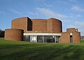
The building has three storeys and a gross floor area of 5,433 square metres (58,480 sq ft). A separate "Energy Centre" adds another 216 square metres (2,330 sq ft) to The Keep's footprint. [31] The main building is intended to have capacity for 20 years worth of records; a further 14 years worth of capacity could be added with an extension at the southwest side, for which provision has been made in the design. Up to 270 public users and 35 members of staff can accommodated: the maximum capacities of the lecture rooms and reading rooms are 155 and 115 respectively. [20] Architecturally, The Keep is a rectangular structure with pale brickwork and some rendering, metal-framed windows and doors, a silver metal roof with areas of vegetation and wildflowers, and an "embossed concrete frieze" near the roofline to "create additional visual interest and ... break down the mass of the block". The building is 14 metres (46 ft) high, 73 metres (240 ft) long and 32.5 metres (107 ft) wide. The design is said to reflect that of "many educational buildings which have been developed in a similar architectural idiom". [32]

Remit and facilities

The Keep houses all of the archives, documents and historical records of both East Sussex County Council and Brighton & Hove City Council. The University of Sussex's Special Collections are also included, including the records of the "internationally renowned" Mass-Observation project [26] and manuscripts by Rudyard Kipling and Virginia Woolf. [28] The Sussex Family History Group (which covers both East and West Sussex) is based in the building and has its library there.

Facilities are provided for public access and research. Educational visits by schools and other institutions, volunteer groups, societies and similar are catered for. [26] [33] Facilities include lecture rooms, a public reading/study room and similar provision for staff, a recording centre for oral histories, conservation laboratories and areas where archive materials can be repaired, repositories for storage, reprographic and record digitisation facilities, offices, eating and refreshment areas, toilets and a separate Energy Centre. [31] [33]

By generating electricity from photovoltaic panels, turning rainwater into usable water and generating heat from a biomass boiler, this facility will help The Keep meet its aim of being "the most sustainable archive building in the country". [6]

The Keep is open to the public at the following times:

Tuesday – 10am – 4pm

Wednesday – 10am – 4pm

Thursday – 10am – 1pm

Friday – 10am – 4pm

Saturday – 10am – 1pm

Sunday and Monday – Closed [34]

Visiting information, including guides on how to book material in advance of a visit, can be found on The Keep's website.

See also

Notes

  1. 1 2 Vowles, Neil (5 June 2013). "New £19million Brighton archives centre opens its doors". The Argus . Newsquest Media Group. Archived from the original on 2 November 2013. Retrieved 6 June 2013.
  2. 1 2 Scott-Delany, Finn (31 October 2013). "Treasured moments to Keep as the Queen opens archive in Brighton". The Argus . Newsquest Media Group. Archived from the original on 2 November 2013. Retrieved 31 October 2013.
  3. Collins 2007 , pp. 10–11.
  4. Historic England. "The Maltings (Grade II) (1190333)". National Heritage List for England . Retrieved 10 December 2012.
  5. "Plan for Sussex archive centre goes before public". BBC News. 26 April 2010. Archived from the original on 4 November 2013. Retrieved 10 December 2012.
  6. 1 2 3 4 5 Tarver, Nick (28 January 2011). "'The Keep' saves East Sussex archive from exile". BBC News. Archived from the original on 3 November 2013. Retrieved 10 December 2012.
  7. 1 2 3 4 Allard & McSweeney 2010 , p. 1.
  8. 1 2 Allard & McSweeney 2010 , p. 5.
  9. 1 2 Allard & McSweeney 2010 , p. 6.
  10. 1 2 3 4 5 Allard & McSweeney 2010 , p. 4.
  11. 1 2 Allard & McSweeney 2010 , p. 7.
  12. Allard & McSweeney 2010 , p. 10.
  13. Allard & McSweeney 2010 , pp. 12–13.
  14. Allard & McSweeney 2010 , p. 16.
  15. "Brighton's fresh food deserts". The Argus . Newsquest Media Group. 9 December 2012. Archived from the original on 10 June 2015. Retrieved 10 December 2012.
  16. Allard & McSweeney 2010 , p. 13.
  17. Allard & McSweeney 2010 , p. 20.
  18. Allard & McSweeney 2010 , p. 21.
  19. "Where is The Keep?". East Sussex County Council. 2012. Archived from the original on 5 January 2013. Retrieved 23 December 2012.
  20. 1 2 Allard & McSweeney 2010 , p. 18.
  21. Allard & McSweeney 2010 , p. 31.
  22. Allard & McSweeney 2010 , pp. 2–3.
  23. 1 2 Allard & McSweeney 2010 , p. 9.
  24. "History on the move". Friends of East Sussex Record Office. 2012. Archived from the original on 22 December 2012. Retrieved 10 December 2012.
  25. 1 2 "Work on Sussex archive centre to begin". The Argus . Newsquest Media Group. 5 October 2011. Archived from the original on 10 June 2015. Retrieved 23 December 2012.
  26. 1 2 3 "The Keep". Brighton & Hove City Council. 2012. Archived from the original on 30 August 2012. Retrieved 23 December 2012.
  27. "Details for application number: BH2010/03259". Brighton & Hove City Council. 14 January 2011. Archived from the original on 5 September 2012. Retrieved 23 December 2012. Construction of a 1–3-storey archive centre comprising lecture and educational facilities, reading room, conservation laboratories, archivist study areas, offices, cleaning and repair facilities for archives, repository block and refreshment area. Associated energy centre, car, coach and cycle parking, waste and recycling storage, landscaping including public open space and access
  28. 1 2 "Topping-out ceremony held at The Keep, East Sussex". Jewson. 8 October 2012. Archived from the original on 14 February 2013. Retrieved 23 December 2012.
  29. "Project timeline". East Sussex County Council. 2012. Archived from the original on 5 January 2013. Retrieved 23 December 2012.
  30. Truman, Peter (26 March 2013). "Brighton artefacts packed up and moved to new home". The Argus . Newsquest Media Group. Archived from the original on 2 November 2013. Retrieved 29 March 2013.
  31. 1 2 Allard & McSweeney 2010 , p. 15.
  32. Allard & McSweeney 2010 , p. 19.
  33. 1 2 "What is The Keep and who is it for?". East Sussex County Council. 2012. Archived from the original on 5 January 2013. Retrieved 23 December 2012.
  34. Keep, The (2023). "Public Visiting Hours" . Retrieved 22 March 2023.

Bibliography

Related Research Articles

<span class="mw-page-title-main">Brighton</span> Seaside resort on the south coast of England

Brighton is a seaside town and one of the two main areas of the city of Brighton and Hove in the county of East Sussex, England. It is located 47 miles (76 km) south of London. Archaeological evidence of settlement in the area dates back to the Bronze Age, Roman and Anglo-Saxon periods. The ancient settlement of "Brighthelmstone" was documented in the Domesday Book (1086). The town's importance grew in the Middle Ages as the Old Town developed, but it languished in the early modern period, affected by foreign attacks, storms, a suffering economy and a declining population. Brighton began to attract more visitors following improved road transport to London and becoming a boarding point for boats travelling to France. The town also developed in popularity as a health resort for sea bathing as a purported cure for illnesses.

<span class="mw-page-title-main">East Sussex</span> County of England

East Sussex is a ceremonial county in South East England. It is bordered by Kent to the north-east, West Sussex to the west, Surrey to the north-west, and the English Channel to the south. The largest settlement is the city of Brighton and Hove, and the county town is Lewes.

The University of Brighton is a public university based on four campuses in Brighton and Eastbourne on the south coast of England. Its roots can be traced back to 1858 when the Brighton School of Art was opened in the Royal Pavilion. It achieved university status in 1992.

<span class="mw-page-title-main">Brighton and Hove</span> City and unitary authority in England

Brighton and Hove is a unitary authority with city status in East Sussex, England. There are multiple villages alongside the seaside resorts of Brighton and Hove in the district. It is administered by Brighton and Hove City Council, which is currently under Labour majority control.

<span class="mw-page-title-main">Falmer</span> Village near Brighton, England

Falmer is a small village and civil parish in the Lewes District of East Sussex, England, lying between Brighton and Lewes, approximately five miles (8 km) north-east of the former. It is also the site of Brighton & Hove Albion's Falmer Stadium.

<span class="mw-page-title-main">Falmer Stadium</span> Association football stadium in Brighton & Hove

Falmer Stadium, known for sponsorship purposes as the American Express Stadium and more commonly referred to as the Amex, is a football stadium in Falmer, Brighton and Hove, East Sussex. With a capacity of 31,876, it is the second largest stadium in all of South East England, and the 31st largest stadium in the United Kingdom.

<span class="mw-page-title-main">Brighton Kemptown (UK Parliament constituency)</span> UK Parliament constituency in England since 1950

Brighton Kemptown, often referred to as Brighton Kemptown and Peacehaven by local political parties, is a constituency represented in the House of Commons of the UK Parliament since 2017 by Lloyd Russell-Moyle, a Labour Co-op MP.

<span class="mw-page-title-main">Moulsecoomb</span> Human settlement in England

Moulsecoomb is a suburb of Brighton, Sussex, England, on the northeast side around the A270 Lewes Road, between Coldean and Bevendean, 2+14 miles (3.6 km) north of the seafront. The eastern edge adjoins Falmer Hill on the South Downs. It is often divided into smaller sections on maps: North Moulsecoomb, East Moulsecoomb and South Moulsecoomb.

<span class="mw-page-title-main">Coldean</span> Suburb of Brighton and Hove, England

Coldean is a suburb of the English city of Brighton and Hove. Located in the northeast corner of the urban area, it was developed by Brighton Corporation in the 1950s as one of several postwar council estates necessitated by the acute housing shortage in the area after World War II.

<span class="mw-page-title-main">Stanmer Church</span> Church

Stanmer Church is a former Anglican church in Stanmer village, on the northeastern edge of the English city of Brighton and Hove. The ancient village stands within Stanmer Park, the former private estate of the Earl of Chichester, which the Brighton Corporation acquired for the benefit of Brighton's citizens after the Second World War. The church and a stately home, Stanmer House, stand outside the village but within the park's boundaries. The church, which was declared redundant in 2008, has been listed at Grade II by English Heritage for its architectural and historical importance.

<span class="mw-page-title-main">Buildings and architecture of Brighton and Hove</span>

Brighton and Hove, a city on the English Channel coast in southeast England, has a large and diverse stock of buildings "unrivalled architecturally" among the country's seaside resorts. The urban area, designated a city in 2000, is made up of the formerly separate towns of Brighton and Hove, nearby villages such as Portslade, Patcham and Rottingdean, and 20th-century estates such as Moulsecoomb and Mile Oak. The conurbation was first united in 1997 as a unitary authority and has a population of about 253,000. About half of the 20,430-acre (8,270 ha) geographical area is classed as built up.

<span class="mw-page-title-main">British Engineerium</span> Museum in Hove, East Sussex, UK

The British Engineerium is an engineering and steam power museum in Hove, East Sussex. It is housed in the Goldstone Pumping Station, a set of High Victorian Gothic buildings started in 1866. The Goldstone Pumping Station supplied water to the local area for more than a century before it was converted to its present use. The site has been closed to the public since 2006, and in March 2018 the entire complex was put up for sale.

<span class="mw-page-title-main">Moulsecoomb Place</span> Historic site in Brighton and Hove , United Kingdom

Moulsecoomb Place is a large 18th-century house on Lewes Road in the Moulsecoomb area of the English coastal city of Brighton and Hove. Originally a farmhouse based in an agricultural area in the parish of Patcham, north of Brighton, it was bought and extensively remodelled in 1790 for a long-established local family. It was their seat for over 100 years, but the Neoclassical-style mansion and its grounds were bought by the local council in the interwar period when Moulsecoomb was transformed into a major council estate. Subsequent uses have varied, and Moulsecoomb Place later became part of the University of Brighton's range of buildings. Student housing has been built to the rear; but much of the grounds, the house itself and a much older cottage and barn attached to the rear have been preserved. The house is a Grade II Listed building.

<span class="mw-page-title-main">Bear Road, Brighton</span>

The Bear Road area is a largely residential area in the east of Brighton, part of the English city of Brighton and Hove. Centred on the steep west–east road of that name, it is characterised by terraced houses of the early 20th century, but Brighton's main cemeteries were established here in the 19th century and there is also some industry.

<span class="mw-page-title-main">Libraries in Brighton and Hove</span>

The English coastal city of Brighton and Hove has a long and varied history of libraries going back over 250 years. Subscription libraries were among the earliest buildings in the resort of Brighton, which developed in the late 18th century; by the 1780s these facilities, which were more like social clubs than conventional book-borrowing venues, were at the heart of the town's social scene. The Brighton Literary Society, its successor the Brighton Royal Literary and Scientific Institution and its rival the Sussex Scientific Institution between them established a "very fine collection" of publications by the mid-19th century, and these books were donated to the town when a public library was founded in 1871. Neighbouring Hove, originally a separate village, established its own public library in 1890.

<span class="mw-page-title-main">Public services in Brighton and Hove</span>

Brighton and Hove, a city and unitary authority in the English county of East Sussex, has a wide range of public services funded by national government, East Sussex County Council, Brighton and Hove City Council and other public-sector bodies. Revenue to fund these services comes partly from Council Tax, which is paid annually by residents: this tax provides the city council with nearly 20% of its income and also helps to fund the local police force, Sussex Police, and the county's fire service, East Sussex Fire and Rescue Service. Some of Brighton and Hove's utilities and infrastructure are provided by outside parties, such as utility companies, rather than by the city council.

<span class="mw-page-title-main">Lewes Road, Brighton</span> Major road in Brighton, England

Lewes Road is a major road in the English seaside city of Brighton and Hove. It was part of the A27 cross-country trunk route until the Brighton Bypass took this designation in the 1990s; since then it has been designated the A270. The road runs northeastwards from central Brighton through a steep-sided valley, joining the A27 at the city boundary and continuing to Lewes, the county town of East Sussex.