Regency Square, Brighton

Last updated

Regency Square
Regency Square, Brighton (General View from South).JPG
General view of the square from the south
LocationRegency Square, Brighton, Brighton and Hove, East Sussex, United Kingdom
Coordinates 50°49′21″N0°09′01″W / 50.8226°N 0.1504°W / 50.8226; -0.1504
Built1818–1828
Built forJoshua Hanson
Architect Amon Wilds, Amon Henry Wilds (attr.)
Architectural style(s) Regency/Classical
Listed Building – Grade II*
Official name2–4 Regency Square;
5–20 Regency Square;
26–37 Regency Square;
51–56 Regency Square;
57–59 Regency Square;
60–66 Regency Square;
131 King's Road
Designated13 October 1952
Reference no.1380802; 1380803; 1380805; 1380811; 1380812; 1380813; 1381640
Listed Building – Grade II
Official name22–25 Regency Square;
38–46 Regency Square;
46a Regency Square;
46b Regency Square;
47–49 Regency Square
Designated20 August 1971 (22–25, 38–46);
26 August 1999 (others)
Reference no.1380804; 1380806; 1380807; 1380808; 1380809
Location map Brighton central.png
Red pog.svg
Location within central Brighton

Regency Square is a large early 19th-century residential development on the seafront in Brighton, part of the British city of Brighton and Hove. Conceived by speculative developer Joshua Hanson as Brighton underwent its rapid transformation into a fashionable resort, the three-sided "set piece" [1] of 69 houses and associated structures was built between 1818 and 1832. Most of the houses overlooking the central garden were complete by 1824. [2] The site was previously known, briefly and unofficially, as Belle Vue Field. [3]

Contents

The square was a prestigious, high-class development, attracting the social elite. [4] The central garden, originally private, has been council-owned since 1885 and publicly accessible since WW2. [5] An underground car park was built beneath it in 1969. [6]

Most of the buildings in and around the square have been designated Listed buildings: 47 houses are each listed at Grade II*, the second-highest designation, while 18 other houses, a war memorial, a nearby inn and a set of bollards outside it have each been given the lower Grade II status. The house at the southwest corner is now numbered as part of King's Road but was built as part of Regency Square, and is also Grade II*-listed.

History

Belle Vue Field

Regency Square was built on one of the fields to the west of the town but within the parish of Brighton. The field was briefly and unofficially known as Belle Vue Field after it was acquired by Francis Hanson, the owner of the nearby Belle Vue House, in the late 1790s. [3]

Belle Vue House was built near to a windmill known as West Mill. The windmill was owned by Matthew Bourne in 1744, but was not marked on Ogilby's 1762 map, although a windmill is shown on Lambert's View of Brighthelmstone which is dated 1765. In the 1790s, the windmill was owned by John Streeter. [7] On 28 March 1797, when 86 oxen dragged it 2 miles (3.2 km) uphill on a sled to the nearby village of Preston. [8] It was re-erected there and renamed Preston Mill. [9] After several more renamings, it was demolished in 1881. Its machinery was cannibalised by the owners of nearby Waterhall Mill. [10] A watercolour painting, now displayed at Preston Manor, shows crowds of people watching the mill's removal to Preston. [10] [11]

By the late 18th century, Brighthelmstone (as it was originally known) had begun to develop into a fashionable coastal resort. [12] When the annual town fair could no longer be accommodated on its traditional site in the Old Town, Belle Vue Field was used as one of several temporary locations. [13]

Belle Vue Field is sometimes said to have been the site, in 1793, of a 10,000-man military encampment. [14] However, Belle Vue Field did not yet exist in 1793 and contemporaneous sources show that the encampment occupied a much wider area of land, extending as far as the boundary with the neighbouring parish of Hove. [15] Jane Austen refers to the encampment in her novel Pride and Prejudice (written in 1796 and published in 1813). The heroine Elizabeth Bennet's sister is invited to Brighton and elopes with, and later marries, army officer George Wickham. [16] The annual military encampments moved to other sites in and around Brighthelmstone in subsequent years. [17]

Hanson builds the square

In 1818, the field was acquired by Francis Hanson's son, Joshua Flesher Hanson, a businessman. [18] By this time, Brighton's profile was such that speculators were commissioning architects and builders to design and lay out sea-facing residential developments to attract wealthy long-term visitors or permanent residents. Royal Crescent, New Steine and Bedford Square were already in existence; Clarence Square, Russell Square and Marine Parade were being developed. [19]

Hanson's plan for Regency Square was on a much larger scale than these developments. He divided Belle Vue Field into 69 plots, leased them individually and put strict covenants in place, demanding that each house be built in a specific style in order to ensure architectural harmony. In return, the leaseholders (mostly private builders) would have the right to buy, and would end up with houses much larger than average for the town, with excellent sea views and exclusive access to the large central garden. [14] [6] [20] [21] Most leaseholders bought the houses as soon as they could, which was to Hanson's advantage as he made money and had no ongoing responsibility for the buildings. [9] Restrictions in the covenants included the requirement to erect a façade with an iron balcony, to clad the area below the balcony in stucco, to paint the façade at least every three years, to repair any damage, and to pay towards maintenance of the central garden. No stucco was to be applied above the balcony line. [22]

The covenants included a requirement to form a residents' committee, whose job it was to ensure the covenants were obeyed and to impose a levy on the occupiers of the houses to pay for the upkeep of the garden. [23]

Regency Tavern stands at the northeastern corner of the square Regency Tavern, Regency Square, Brighton (IoE Code 481140) crop.jpg
Regency Tavern stands at the northeastern corner of the square

Although there is no documentary evidence confirming the architects, most sources attribute Regency Square's buildings to the father-and-son partnership of Amon and Amon Henry Wilds, [14] [24] [9] [25] who moved to Brighton from nearby Lewes in 1815 and became two of Brighton's most important architects; they were extremely prolific, and were responsible for defining and developing the town's distinctive Regency style. [26] [27] Although they worked extensively with fellow architect Charles Busby during the 1820s, historians agree that he was not involved in Regency Square, at least not in its early stages: the buildings "appear to lack his distinctive flair" [24] and are not as impressive as those at the Kemp Town estate to the east of Brighton, which all three men were involved with. [9] No. 1 Regency Square (now 131 Kings Road) is confirmed as the work of Amon Henry Wilds. [28] Some evidence points to William Mackie being involved in the design of houses on the east side of the square. [28]

Building work started in 1818 and continued until 1832, with most of the houses complete by 1824. [29] A passageway (Regency Colonnade) was built at the northeast corner to connect the square to the neighbouring development of Russell Square. [30] The Regency Tavern has occupied most of the passageway since the 1870s, all of it since 1939. [31] St Margaret's Church, an Anglican chapel of ease designed in the Greek Revival/Neoclassical style in 1824 by Busby, was the local place of worship. [32]

131 King's Road was formerly known as 1 Regency Square and St Albans House The Regency March 2017 01.jpg
131 King's Road was formerly known as 1 Regency Square and St Albans House

In 1866 the West Pier, designed by Eugenius Birch, was built opposite the square's central garden. [33]

Unusually, Hanson had set a 71-year time limit on the covenants rather than granting them in perpetuity, and on 25 December 1889 they were due to expire. Among other things, residents would then lose their rights to use the gardens. The residents committee, led by solicitor Somers Clarke (unrelated to the Brighton-born architect of that name), attempted unsuccessfully to purchase the gardens and extend the covenants by an Act of Parliament; [34] two years later, the passing of the Brighton Improvement Act 1884 achieved the same aims. Brighton Corporation took ownership of the gardens, and householders signed new deeds confirming they wished for the covenants relating to their houses to be extended indefinitely. [14] [35]

20th century

From the beginning, Regency Square was a prestigious, high-class development, [4] and it is still considered to be "one of Brighton's best sea-facing squares". [1] By the mid-20th century most of the houses had become hotels, [14] but the majority have since been converted into flats and the square today is overwhelmingly residential. [36] In early 1963 a surface-level car park was planned for the Brighton Corporation owned central garden; [37] this was changed to a 520-space underground car park, created in 1967-9 using the cut and cover method in which the garden was dug up, the car park with roof constructed, and the lawns and flowerbeds restored. [14]

Richard Seifert's 334-foot (102 m), Modernist 24-storey residential block, Sussex Heights, was built in 1968 on land immediately to the east of the square, and was criticised for affecting the character of the square because of its contrasting style and height. [1] [38]

During the early 1970s the hotels sought permission from Brighton Corporation to erect neon signs advertising themselves; after negotiation with the Regency Society, a Brighton-wide conservation group formed in 1945, [39] the Corporation made the square and the surrounding area into a conservation area in 1973. [14] [40] Conservation area status gives the council firmer control over planning permission and changes to buildings or street furniture, especially in respect of their effect on "the character and appearance of the area". [41] The original conservation area has since been enlarged twice to its present size of 80 acres (32 ha). [30]

Architecture

Almost all buildings in Regency Square have been designated a Listed building: 47 houses are each listed at Grade II*, while 18 other houses, a memorial, an inn and a set of bollards, have each been given the lower Grade II status. The house at the south west corner is now numbered as part of King's Road, but was built as part of Regency Square and is also Grade II*-listed.

The five Grade II* parts of the square, including the house at the south west corner (formerly St Albans House), [42] were listed on 13 October 1952.

The entire west side was listed in 1952: St Albans House, the three houses at numbers 2–4 [43] and the sixteen houses at number 5-20. [44] The northern side's central section, numbers 26–37, forms another Grade II* listing. [45] On the east side, all of the surviving original houses, at numbers 51–56, [46] 57–59 [47] and 60–66, [48] are listed at Grade II*. Apart from St Albans House, all of these listings include iron railings attached to the exterior.

Numbers 22–25 and 38–46, on the north side, were listed at Grade II on 20 August 1971, [49] [50] while most of the rest of the square's original houses were listed at the same grade on 26 August 1999: numbers 46a, [51] 46b [52] and 47–49. [53] All listings except numbers 46a and 46b include attached railings. The listing for numbers 38–46 includes a carriage arch, which has nonetheless been lost.

A small block of flats, Abbotts, stands at the southeast corner of the square. Built by architecture firm Fitzroy Robinson & Partners in 1961–62, it replaced three of the original Regency Square houses (nos. 67–69) which, along with the neighbouring property at 129 Kings Road, had been converted into a hotel of the same name in the early part of the 20th century. [54] The original four houses were considered "quite good" by architectural historian Nikolaus Pevsner. [55]

Grade II* listings

2–4 Regency Square
2-4 Regency Square 2-4 Regency Square, Brighton (IoE Code 481126).jpg
2–4 Regency Square

These three four-storey houses (now the Beach Hotel) have double bow fronts, and were considered by Nikolaus Pevsner to be more austere in their detailing than most Brighton houses of their era. [55] Number 2, a former home of social reformer William King (whose two-year stay is commemorated by a blue plaque), is built of brick which has been painted over; the others are stuccoed. [43] Each house also has a basement and a dormer window. The ground floors are rusticated and have arched doorways set into Classical-style porches with both Ionic and Doric columns—the latter in the form of antae. The tripartite bay windows are neither full-height nor continuous: only the first three storeys have them, and they are offset to the right on the first and second floors. [43] The first-floor windows sit between a curved cast-iron balcony and a verandah-style canopy supported on decorative brackets. On each house, the third floor has three small flat-arched sash windows; the centre window sits below a small cornice supported on corbels. [6] [43]

5–20 Regency Square
5-20 Regency Square 5-20 Regency Square, Brighton (IoE Code 481127).jpg
5–20 Regency Square

These sixteen houses form the greater part of the square's west side. Although there are differences in height and detail between individual houses, they were designed at the same time and maintain "the longstanding tradition of the terraced townhouse" which had been developed "by Henry Holland [...] in his own speculative enterprises at Hans Town and Sloane Street, London". [24] [25] Numbers 7, 8, 11 and 15 are entirely stuccoed; number 18 retains its original unpainted yellow-brick upper façade; and all other houses have painted brick to their upper storeys and stuccoed ground floors with rustication. [44] The roofs are mansard-style and laid with slate. Each house has dormer windows; numbers 5–13 inclusive rise to four storeys, while the other seven houses are one storey shorter. All houses except number 12 have a single bay window, mostly in tripartite form. Number 12 has three windows to each floor. [44] The entrance porches, reached via staircases, are either Doric or Ionic in form, with columns and entablatures. They have arch-headed doorways set into them. Small cast-iron balconies run across the terrace at first-floor level (although number 5's has been lost), and some houses have canopy-style verandahs as well. A nearly continuous cornice (absent on numbers 13 and 19) spans the terrace; some houses also have a second cornice above this. [44] Several houses have fanlights with coloured glass, and other non-standard details include decorative stucco panelling at number 5; paterae (circular motifs), triglyph-decorated friezes and other Classical-style ornamentation in some of the porch entablatures; original window-guards of iron; a blocked doorway flanked by pilasters at number 20; and many original sash windows. [6] [44]

26–37 Regency Square
26-37 Regency Square 26-37 Regency Square, Brighton (IoE Code 481129).jpg
26–37 Regency Square

These 12 houses, arranged along the sea-facing north side in the form of two wings flanking a four-house centrepiece, are the focal point of the square, forming "a kind of palace front" topped with a pediment displaying Regency Square in prominent black lettering. [14] [6] Pevsner described this feature as "not [being] enough of an accent to pull the square together". [55] The terrace is a five-part composition: the end "wings" (formed by numbers 26–27 and 36–37) are of four storeys, stuccoed and with tall parapets pinched upwards to form small pediments; the central section (numbers 30–33), also of four storeys and built in yellow brick, and topped with the inscribed pediment; and numbers 28–29 and 34–35, rising to three storeys and forming a link between the central and outer sections. [14] [6] [45] Numbers 30–33 have a two-window range, rather than the single window on each of the other houses, and have four pilasters running the full height of the façade and terminating at the parapet in circular antefixae. [6] [45] The entrance porches are of the Ionic order. Each house has a canopied cast-iron balcony at first-floor level. There is rusticated decoration at ground-floor level. [45]

51–56 Regency Square
51-56 Regency Square with Sussex Heights behind 51-56 Regency Square, Brighton (IoE Code 481135).jpg
51–56 Regency Square with Sussex Heights behind

The east side of Regency Square is architecturally less consistent than either the north or west sides. [6] Numbers 51–56 were designed as a symmetrical composition: the two houses at the centre stand forward slightly and have a more prominent pediment. Each house has four storeys and a single bay window on the ground and first floors; other common features include rustication on the ground floor and Ionic-style porches with recessed flat-arched doorways and arched fanlights. There are cast-iron balconies at first-floor level; number 52's has a canopy above it. Some windows are sashes, and numbers 52, 53, 54 and 56 have dormer windows in their slate roofs. [46]

57–59 Regency Square
57-59 Regency Square 57-59 Regency Square, Brighton (IoE Code 481136) crop.jpg
57–59 Regency Square

These three houses may also have been designed as a single composition, but this effect has been lost. Numbers 58 and 59 are of five storeys; number 57 has four storeys and dormer windows. The parapet rises into an intricately decorated pediment above number 58, with palmette scrollwork and semicircular antefixae. Each house has an Ionic-columned porch with a straight-headed door and semicircular fanlight. Numbers 57 and 59 have canopies and first-floor balconies; number 58 has only a balcony. [47] The three houses are the only ones on the east side to have full-height bows, and number 57 is unique on that side in retaining its original unpainted yellow-brick façade. [6]

60–66 Regency Square
60-66 Regency Square 60-66 Regency Square, Brighton (IoE Code 481137).jpg
60–66 Regency Square

These seven houses are also a symmetrical composition: the three in the middle are set forward and have a tall parapet topped by a very shallow pediment. Like the rest of the east side, [6] the houses have Ionic porches with flat-arched doors and round-headed fanlights. The ground and first floors have three-part bay windows topped with cornices. Except on number 63, a narrow canopy sits between the first-floor window and the cornice. Another cornice spans the full width of the terrace above third-floor level. The slightly recessed houses on each end (numbers 60–61 and 65–66) have pairs of dormer windows. [48]

131 King's Road

The former St Albans House was designed in 1828 by Amon Henry Wilds alone and was fitted out by William Izard. [24] [35] A shopfront was fitted in the early 20th century, [42] and the ground floor has housed a restaurant since 1930. [56] Contemporary with the shopfront was the round-headed entrance on the King's Road elevation, with an archway supported on fluted columns, a dentil-patterned cornice and ornamentation including scrollwork and a panel inscribed St Albans. [42] The building has five storeys, three windows facing King's Road and the sea, and a five-window range to Regency Square. It is stuccoed and slate-roofed. The shopfront is topped by a thin cast-iron balcony. The right-hand (east) side of the King's Road façade has a full-height tripartite segmental bay window with architraves to each window. The Regency Square elevation also has a three-light full-height bay window; all other windows are blocked. [42]

Grade II listings

22-25 Regency Square and 67 Preston Street, Brighton (IoE Code 481128).jpg
22–25 Regency Square
38-46 Regency Square, Brighton (IoE Code 481130).jpg
38–46 Regency Square
22–25 Regency Square

Numbers 22–25 Regency Square—at the northwest corner of the square on a short road leading to Preston Street—include the building (number 67) on the corner of that street, which absorbed the house built as number 21 Regency Square. [49] These bow-fronted terraced houses were built in the early 1820s. [2] Number 67 Preston Street is of three storeys and has a shopfront facing west into that street; alongside that is a porch with rusticated decoration and an arched doorway. The Regency Square (south) façade has blocked windows at first- and second-floor level. [49] The four houses facing Regency Square are of three storeys, except number 25 which also has an attic storey. They are of brick faced with painted stucco. Each house has a chimney on its slate roof. Each has an entrance staircase with iron railings, a rusticated ground floor, a single bay window to each storey, an iron balcony at first-floor level, a cornice and a parapet in front of the roof. At numbers 22 to 24, dormer windows cut through the parapet. [49]

38–46 Regency Square

Numbers 38–46 Regency Square run alongside the northeast side, and are contemporary with the houses at the northwest corner. A carriage arch ran between numbers 42 and 43. [50] Together with numbers 22–25 and the Grade II*-listed centrepiece of numbers 26–37, the houses form an approximately symmetrical three-part arrangement when viewed from the south. [14] Each house is of stucco-clad brick, and all but number 40 have slate-covered roofs. All houses rise to three storeys and have dormer windows; number 43 has two bay windows on each floor (except the ground floor, where the space is taken up by the carriage arch), but the other houses have only one. Each house also has a balcony, a cornice and a parapet (topped with a balustrade in some cases). [50]

46a Regency Square

Number 46a Regency Square stands partly in the square and partly in the passageway opposite the Regency Tavern. It is thought to have been the last property to be completed. Originally built as a single storey architect's studio, it acquired an upper storey in the 1960s [57] and is now a two-storey stucco-faced cottage with three windows on the first floor and a fourth in a recessed wing on the east side. The flat roof sits behind a parapet. The ground floor has a broad single window flanked by decorative panels. A cornice runs between the two storeys, and projects forward over the right-aligned entrance. [51]

46b Regency Square

Number 46b Regency Square is squeezed into a narrow corner between number 47 and the Regency Tavern. It has three storeys, a single-window range and much ornamentation. The ground floor is a 20th-century alteration. [58] Above it, pilasters with banded rustication rise to the level of the parapet. They are broken at second-floor level by a small balcony with balustrades. The window above this has a round arch, a moulded archivolt, a keystone with acanthus decoration and thin pilasters topped with capitals in the form of leaves. [52]

47–49 Regency Square

Numbers 47–49 Regency Square are noticeably different from the rest of the square. [14] [24] [22] All three have a single canted bay window to each of three storeys, topped with an architrave supported on pilasters with capitals. However, the canted bay windows are late 19th century alterations. When built in 1832, the houses were variously bow-windowed or flat fronted. [31] Each house also has a cornice and parapet. Number 47's doorway is straight-headed, but the other two houses have round-arched entrances. [53]

Sir John Simpson's South African War Memorial South African War Memorial, Regency Square, Brighton (IoE Code 481139) crop.jpg
Sir John Simpson's South African War Memorial
War memorial

A memorial commemorating 152 members of the Royal Sussex Regiment who died in the Second Boer War stands at the south end of Regency Square's garden, facing King's Road and the sea. It was erected in 1904, [59] and takes the form of a square pedestal topped by an entablature and pediment. Originally of Portland stone with some bronze and stucco, the bronze parts have now been obscured. A bronze trumpeter stands on top of the entablature. [60] Local architect Sir John Simpson designed the memorial and Charles Hartwell sculpted it. [61] [62] The memorial's unveiling ceremony, conducted by William Nevill, 1st Marquess of Abergavenny, was on 29 October 1904. [59]

Regency Tavern

The Regency Tavern's main façade faces north into the passageway leading to Russell Square, and has a six-window range. The side wall, facing into Regency Square, has two windows to each of the three storeys. The frontage is assumed to be mostly original, although it was built, in 1829, as a row of three individual houses, which merged into a single establishment in two phases in the late 19th and mid 20th centuries. [31] The frontage has been augmented by modern iron columns. All but one of the windows are original sashes; those on the first floor of the Regency Square elevation have architraves which join the sill of the second-floor window directly above. There are stuccoed panels between these windows as well, and some of the north-facing windows also have panelling in their spandrels. A tall parapet rises above the cornice. [63]

Bollards

Two cast-iron bollards in the passageway outside the Regency Tavern are also listed at Grade II. They were erected in the mid-19th century, and are fluted along their length. One has the name of its local founder at the bottom. [64] On 31 December 2012, one was broken and was replaced with a smaller plain bollard instead of a facsimile, causing controversy locally. [65]

Social aspects

Regency Square was a prestigious, high-class development, attracting the social elite. [4] The square gradually lost its prestige status after World War I as hotels started to move in. [66] Although most of the houses had become hotels by the mid-20th century, the majority have since been converted into flats and the square today is overwhelmingly residential. [14] [36]

Military bands gave a performance in the garden in 1831 and 1849, and again in 1904 at the unveiling of the Royal Sussex Regiment Memorial, but the residents' committees strove to ensure that the garden was mainly a quiet space for residents. [34] [67] In the 1890s, temporary tennis courts were marked out on the lawn. [68] During World War II air-raid shelters were built on the square [66] and an underground car park was built beneath it in 1969. [6]

Number 1 Regency Square, later known as St Albans House and now numbered 131 King's Road, [42] is "historically the most interesting house in the square". [24] Amon Henry Wilds designed and built it in 1829, William Izard laid out the interior. [35] The house was one of the most important social venues in Brighton between 1830 and the Duchess's death in 1837. She was born Harriet Mellon in 1777, became an actress, married banker Thomas Coutts in 1815, and inherited his fortune when he died in 1822—thereby becoming England's richest woman. [35] After being courted by many men, she met and married William Beauclerk, the 9th Duke of St Albans, and they became regular visitors to Brighton. From 1830, their prolonged stays at No. 1 Regency Square were so frequent that it was named St Albans House. [69] [70] For the next seven years, it was the venue for lavish balls and extensive feasts, with hundreds of upper-class guests. The Duke was the Grand Falconer of England and occasionally displayed his falcons in the Regency Square garden. [34] St Albans House had a nearby riding school which supposedly had the second largest unsupported interior space and the second largest dome in England, behind Westminster Abbey and St Paul's Cathedral respectively. (Part of the Bedford Hotel now occupies the site.) [69] [70]

Two other famous characters paid an unintentional visit to Regency Square at the end of the 19th century: Oscar Wilde and his lover Lord Alfred Douglas crashed their horse and carriage into the railings of the gardens. Local newspapers reported the story with interest, but Wilde dismissed it as "an accident of no importance" [71] —possibly a punning allusion to one of his best-known plays.

Some of Regency Square's buildings are currently hotels. The Beach Hotel occupies numbers 2–4, the three houses north of St Albans House. [72] Hotel Pelirocco occupies numbers 9 and 10; [73] Hotel 360 is at number 12; [74] and the West Pier Hotel (at numbers 14–15) and Topps Hotel (numbers 16–18) also occupy the west side of the square. [75] There are three hotels on the north side: the Regency at number 28, [76] the Prince Regent at number 29, [77] and the Artist Residence at number 33. [78] The east side has Adelaide House (number 51), [79] Brighton House (number 52), [80] Hotel Una (numbers 55–56), [81] and the Queensbury Hotel (number 58).

Related Research Articles

<span class="mw-page-title-main">Grade I listed buildings in Brighton and Hove</span>

There are 24 Grade I listed buildings in the city of Brighton and Hove, England. The city, on the English Channel coast approximately 52 miles (84 km) south of London, was formed as a unitary authority in 1997 by the merger of the neighbouring towns of Brighton and Hove. Queen Elizabeth II granted city status in 2000.

<span class="mw-page-title-main">Amon Henry Wilds</span>

Amon Henry Wilds was an English architect. He was part of a team of three architects and builders who—working together or independently at different times—were almost solely responsible for a surge in residential construction and development in early 19th-century Brighton, which until then had been a small but increasingly fashionable seaside resort on the East Sussex coast. In the 1820s, when Wilds, his father Amon Wilds and Charles Busby were at their most active, nearly 4,000 new houses were built, along with many hotels, churches and venues for socialising; most of these still survive, giving Brighton a distinctive Regency-era character, and many are listed buildings.

<span class="mw-page-title-main">Grade II* listed buildings in Brighton and Hove</span>

There are 72 Grade II* listed buildings in the city of Brighton and Hove, England. The city, on the English Channel coast approximately 52 miles (84 km) south of London, was formed as a unitary authority in 1997 by the merger of the neighbouring towns of Brighton and Hove. Queen Elizabeth II granted city status in 2000.

<span class="mw-page-title-main">Royal Albion Hotel</span> Hotel in Brighton, England

The Royal Albion Hotel is a 3-star hotel, on the corner of Old Steine and Kings Road in Brighton, England. Built on the site of a house belonging to Richard Russell, a local doctor whose advocacy of sea-bathing and seawater drinking helped to make Brighton fashionable in the 18th century, it has been extended several times, although it experienced a period of rundown and closure in the early 20th century. A fire in 1998 caused serious damage, and the hotel was restored. However, another fire in 2023 seriously damaged the building to the extent that demolition of the western part of the building began on 19 July 2023.

<span class="mw-page-title-main">Royal Crescent, Brighton</span> Historic site in East Sussex , England

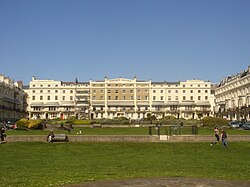
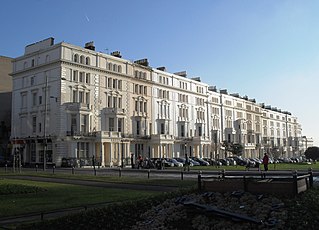
Royal Crescent is a crescent-shaped terrace of houses on the seafront in Brighton, part of the English city of Brighton and Hove. Built in the late 18th and early 19th century as a speculative development on the open cliffs east of Brighton by a wealthy merchant, the 14 lodging houses formed the town's eastern boundary until about 1820. It was the seaside resort's first planned architectural composition, and the first built intentionally to face the sea. The variety of building materials used include black glazed mathematical tiles—a characteristic feature of Brighton's 18th-century architecture. English Heritage has listed the crescent at Grade II* for its architectural and historical importance. An adjacent five-storey building, formerly the Royal Crescent Hotel but now converted into flats with the name Royal Crescent Mansions, is listed separately at Grade II.

<span class="mw-page-title-main">Sussex Heights</span> Residential tower block in Brighton and Hove, United Kingdom

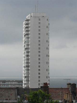
Sussex Heights is a residential tower block in the centre of Brighton, part of the English city of Brighton and Hove. Built between 1966 and 1968 on the site of a historic church, it rises to 102 m (335 ft) and has 116 flats. As of August 2022, the tower is the 125th tallest building in the UK, and until 2005 it was the tallest residential tower in the UK outside of London. Until 2015, it was the tallest structure in Brighton, however it has now been exceeded by the i360 Tower, which stands at 162 metres.

<span class="mw-page-title-main">Wykeham Terrace, Brighton</span> Historic site in East Sussex, United Kingdom

Wykeham Terrace is a row of 12 early 19th-century houses in central Brighton, part of the English city of Brighton and Hove. The Tudor-Gothic building, attributed to prominent local architect Amon Henry Wilds, is built into the hillside below the churchyard of Brighton's ancient parish church. Uses since its completion in 1830 have included a home for former prostitutes and a base for the Territorial Army, but the terrace is now exclusively residential again. Its "charming" architecture is unusual in Brighton, whose 19th-century buildings are predominantly in the Regency style. English Heritage has listed the terrace at Grade II for its architectural and historical importance.

<span class="mw-page-title-main">French Convalescent Home, Brighton</span> Historic site in East Sussex, United Kingdom

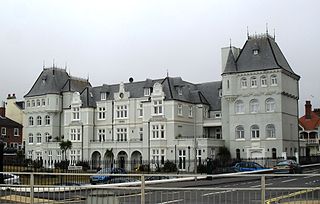
The former French Convalescent Home was a seafront sanatorium and rest home built in Brighton, part of the English seaside city of Brighton and Hove, on behalf of the French government. It received patients from the French Hospital in London and served as a home for elderly French nationals. It was sold for redevelopment in 1999 and was briefly threatened with demolition; but English Heritage listed the building at Grade II for its architectural and historical importance, and it was converted into flats. The unusual château-style French Renaissance Revival building has been criticised as "dreary" and "gauche", but is believed to be unique in England and demonstrated innovation in its use of double glazing.

<span class="mw-page-title-main">Park Crescent, Brighton</span> Terrace of houses in Brighton, East Sussex, UK

Park Crescent is a mid-19th-century residential development in the Round Hill area of Brighton, part of the English city of Brighton and Hove. The horseshoe-shaped, three-part terrace of 48 houses was designed and built by one of Brighton's most important architects, Amon Henry Wilds; by the time work started in 1849 he had 35 years' experience in the town. Wilds used the Italianate style rather than his more common Regency motifs. Three houses were replaced after the Second World War because of bomb damage, and another was the scene of one of Brighton's notorious "trunk murders" of the 1930s. The three parts of the terrace, which encircle a private garden formerly a pleasure ground and cricket pitch, have been listed at Grade II* by English Heritage for their architectural and historical importance.

<span class="mw-page-title-main">Buildings and architecture of Brighton and Hove</span>

Brighton and Hove, a city on the English Channel coast in southeast England, has a large and diverse stock of buildings "unrivalled architecturally" among the country's seaside resorts. The urban area, designated a city in 2000, is made up of the formerly separate towns of Brighton and Hove, nearby villages such as Portslade, Patcham and Rottingdean, and 20th-century estates such as Moulsecoomb and Mile Oak. The conurbation was first united in 1997 as a unitary authority and has a population of about 253,000. About half of the 20,430-acre (8,270 ha) geographical area is classed as built up.

Thomas Lainson, FRIBA was a British architect. He is best known for his work in the East Sussex coastal towns of Brighton and Hove, where several of his eclectic range of residential, commercial and religious buildings have been awarded listed status by English Heritage. Working alone or in partnership with two sons as Lainson & Sons, he designed buildings in a wide range of styles, from Neo-Byzantine to High Victorian Gothic; his work is described as having a "solid style, typical of the time".

<span class="mw-page-title-main">Roundhill Crescent</span> 19th-century housing development in Brighton and Hove

Roundhill Crescent is a late-19th-century housing development in Round Hill, an inner suburb of the English coastal city of Brighton and Hove. Partly developed in the 1860s with large terraced houses on a steeply sloping open hillside, the crescent—which "curves and changes height dramatically along its length"—was finished two decades later and now forms the centrepiece of the Round Hill conservation area. Smaller houses completed the composition in the 1880s, and England's first hospital for the treatment of mental illness was founded in the crescent in 1905. The five original sets of houses from the 1860s have been listed at Grade II by English Heritage for their architectural and historical importance, and the crescent occupies a prominent place on Brighton's skyline.

<span class="mw-page-title-main">20–22 Marlborough Place, Brighton</span> Historic site in Brighton , United Kingdom

The building at 20–22 Marlborough Place in the seaside resort of Brighton, part of the city of Brighton and Hove, is a 1930s office building originally erected for the Citizens' Permanent Building Society. The "elegant" Neo-Georgian premises were later occupied by a branch of the Allied Irish Bank, which opened in the 1980s; and in 2022 it was announced that the premises would be converted into a restaurant. Designed by John Leopold Denman, "master of this sort of mid-century Neo-Georgian", the three-storey offices contrast strikingly with their contemporary neighbour, the elaborate King and Queen pub. The building features a series of carved reliefs by Joseph Cribb depicting workers in the building trade—including one showing Denman himself. It is a Grade II Listed building.

<span class="mw-page-title-main">Montpelier, Brighton</span> Inner suburban area of Brighton, England

Montpelier is an inner suburban area of Brighton, part of the English city and seaside resort of Brighton and Hove. Developed together with the adjacent Clifton Hill area in the mid-19th century, it forms a high-class, architecturally cohesive residential district with "an exceptionally complete character". Stucco-clad terraced housing and villas predominate, but two of the city's most significant Victorian churches and a landmark hospital building are also in the area, which lies immediately northwest of Brighton city centre and spreads as far as the ancient parish boundary with Hove.

<span class="mw-page-title-main">Montpelier Crescent</span> Historic site in East Sussex, United Kingdom

Montpelier Crescent is a mid 19th-century crescent of 38 houses in the Montpelier suburb of the English coastal city of Brighton and Hove. Built in five parts as a set-piece residential development in the rapidly growing seaside resort, the main part of the crescent was designed between 1843 and 1847 by prominent local architect Amon Henry Wilds and is one of his most distinctive compositions. Extra houses were added at both ends of the crescent in the mid-1850s. Unlike most other squares, terraces and crescents in Brighton, it does not face the sea—and the view it originally had towards the South Downs was blocked within a few years by a tall terrace of houses opposite. Montpelier was an exclusive and "salubrious" area of Brighton, and Montpelier Crescent has been called its "great showpiece". Wilds's central section has been protected as Grade II* listed, with the later additions listed separately at the lower Grade II. The crescent is in one of the city's 34 conservation areas, and forms one of several "outstanding examples of late Regency architecture" within it.

<span class="mw-page-title-main">Vernon Terrace, Brighton</span> Historic site in East Sussex, United Kingdom

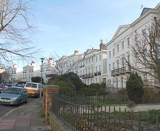
Vernon Terrace is a mid 19th-century residential development in the Montpelier suburb of Brighton, part of the English coastal city of Brighton and Hove. Construction of the first section started in 1856, and the 37-house terrace was complete in the early 1860s. Architecturally, the houses divide into five separate compositions, although all are in a similar late Regency/Italianate style. This was characteristic of houses of that era in Brighton, and especially in the Montpelier area—where the Regency style persisted much later than elsewhere. Standing opposite is the landmark Montpelier Crescent, which had a view of the South Downs until Vernon Terrace blocked it. Three groups of houses in the terrace have been listed at Grade II by English Heritage for their architectural and historical importance.

<span class="mw-page-title-main">Palmeira Square</span> 19th century residences in Hove, England

Palmeira Square is a mid-19th-century residential development in Hove, part of the English city and seaside resort of Brighton and Hove. At the southern end it adjoins Adelaide Crescent, another architectural set-piece which leads down to the seafront; large terraced houses occupy its west and east sides, separated by a public garden; and at the north end is one of Hove's main road junctions. This is also called Palmeira Square, and its north side is lined with late 19th-century terraced mansions. Commercial buildings and a church also stand on the main road, which is served by many buses.

<span class="mw-page-title-main">Royal Pavilion Tavern</span> Historic site in Brighton and Hove, United Kingdom

The Royal Pavilion Tavern, commonly known as the Pavilion Tavern or Pav Tav and since February 2022 as The Fitz Regent, is a pub in the centre of Brighton, part of the English coastal city of Brighton and Hove. Converted from a house into the Royal Pavilion Hotel in the early 19th century, its original role soon changed from a hotel to a pub, in which guise it remained until its closure in September 2019. It reopened under its new name, but still in the ownership of the Mitchells & Butlers chain, on 13 February 2022. The building was also used as a court for several years early in its history, and prominent local architect Amon Henry Wilds was responsible for its redesign as a hotel and inn. English Heritage has listed the building at Grade II for its architectural and historical importance, and it stands within a conservation area.

<span class="mw-page-title-main">Adelaide Crescent</span> 19th century residences in Hove, England

Adelaide Crescent is a mid-19th-century residential development in Hove, part of the English city and seaside resort of Brighton and Hove. Conceived as an ambitious attempt to rival the large, high-class Kemp Town estate east of Brighton, the crescent was not built to its original plan because time and money were insufficient. Nevertheless, together with its northerly neighbour Palmeira Square, it forms one of Hove's most important architectural set-pieces. Building work started in 1830 to the design of Decimus Burton. The adjacent land was originally occupied by "the world's largest conservatory", the Anthaeum; its collapse stopped construction of the crescent, which did not resume until the 1850s. The original design was modified and the crescent was eventually finished in the mid-1860s. Together with the Kemp Town and Brunswick Town estates, the crescent is one of the foremost pre-Victorian residential developments in the Brighton area: it has been claimed that "outside Bath, [they] have no superior in England". The buildings in the main part of Adelaide Crescent are Grade II* listed. Some of the associated buildings at the sea-facing south end are listed at the lower Grade II.

<span class="mw-page-title-main">Clarence House, Brighton</span> Former hotel in Brighton

Clarence House, previously the New Inn (1785–1830) and the Clarence Hotel (1830–1972), is a former coaching inn and hotel in Brighton, part of the English coastal city of Brighton and Hove. The only surviving coaching inn of many which used to stand on North Street, Brighton's main commercial thoroughfare, it retains much of its original "severely plain" Georgian appearance, with Classical features and mathematical tiles; but the interior has been changed since its closure in 1972 and conversion into a mixed-use commercial building. The four-storey structure, which is in a conservation area and which has been listed at Grade II by Historic England for its architectural and historical importance, is empty and has been vandalised and squatted repeatedly, but planning applications were raised in 2021 and 2022 for the creation of two flats and a new restaurant within the building.

References

  1. 1 2 3 Antram & Morrice 2008, p. 104.
  2. 1 2 Wales & Hinton 2018, p. 34.
  3. 1 2 Wales & Hinton 2018, pp. 13, 15.
  4. 1 2 3 Gilbert 1975, p. 98.
  5. Wales & Hinton 2018, p. 78.
  6. 1 2 3 4 5 6 7 8 9 10 11 Antram & Morrice 2008, p. 105.
  7. Wales & Hinton 2018, p. 14.
  8. Dawes 1988, pp. 2–3.
  9. 1 2 3 4 Dale 1967, p. 41.
  10. 1 2 Carder 1990, §55.
  11. Dale 1967, Plate 30.
  12. Carder 1990, §17.
  13. Erredge, John Ackerson (1862). "chapter 28". History of Brighthelmston. Gutenberg e-book #50551.
  14. 1 2 3 4 5 6 7 8 9 10 11 12 Collis 2010, p. 273.
  15. Grant, Roy C. The Brighton Garrison 1793–1900. p. 12.
  16. Melville 1909, pp. 87–88.
  17. Grant, Roy C. The Brighton Garrison 1793–1900.[ page needed ]
  18. Wales & Hinton 2018, p. 19.
  19. Carder 1990, §49.
  20. Dale 1967, pp. 41–42.
  21. Wales & Hinton 2018, p. [ page needed ].
  22. 1 2 Dale 1967, p. 42.
  23. Wales & Hinton 2018, p. 101.
  24. 1 2 3 4 5 6 Brighton Polytechnic 1987, p. 82.
  25. 1 2 Musgrave 1981, p. 177.
  26. Brighton Polytechnic 1987, pp. 12–18.
  27. Collis 2010, p. 370.
  28. 1 2 Wales & Hinton 2018, p. 44.
  29. Wales & Hinton 2018, pp. 34, 37.
  30. 1 2 "Regency Square Conservation Area Character Statement" (PDF). Brighton & Hove City Council. 20 October 2005. Archived from the original (PDF) on 4 March 2016. Retrieved 22 August 2010.
  31. 1 2 3 Wales & Hinton 2018, p. 62.
  32. Dale 1967, p. 43.
  33. Gilbert 1975, p. 164.
  34. 1 2 3 Dale 1967, p. 44.
  35. 1 2 3 4 Dale 1967, p. 45.
  36. 1 2 Wales & Hinton 2018, p. 1.
  37. Wales & Hinton 2018, p. 79.
  38. Brighton Polytechnic 1987, p. 89.
  39. "The Regency Society". regencysociety.org. Retrieved 26 August 2010.
  40. "Conservation Areas in Brighton & Hove". Brighton & Hove City Council (Design & Conservation Department). 2010. Archived from the original on 30 August 2012. Retrieved 4 February 2012.
  41. "Conservation Areas in Brighton & Hove: A Resident's Guide" (PDF). Brighton & Hove City Council. 2003. Archived from the original (PDF) on 2 June 2009. Retrieved 22 August 2010.
  42. 1 2 3 4 5 "No. 131 King's Road (north side) (formerly listed as St Albans House, No. 1 Regency Square), Brighton, Brighton and Hove, East Sussex". Heritage Gateway Online. Heritage Gateway (English Heritage, Institute of Historic Building Conservation and ALGAO:England). Retrieved 29 July 2010.
  43. 1 2 3 4 "Nos. 2, 3 and 4 and attached railings, Regency Square (west side), Brighton, Brighton and Hove, East Sussex". Heritage Gateway Online. Heritage Gateway (English Heritage, Institute of Historic Building Conservation and ALGAO:England). Retrieved 29 July 2010.
  44. 1 2 3 4 5 "Nos. 5–20 (Consecutive) and attached railings, Regency Square (west side), Brighton, Brighton and Hove, East Sussex". Heritage Gateway Online. Heritage Gateway (English Heritage, Institute of Historic Building Conservation and ALGAO:England). Retrieved 29 July 2010.
  45. 1 2 3 4 "Nos. 26–37 (Consecutive) and attached railings, Regency Square (north side), Brighton, Brighton and Hove, East Sussex". Heritage Gateway Online. Heritage Gateway (English Heritage, Institute of Historic Building Conservation and ALGAO:England). Retrieved 29 July 2010.
  46. 1 2 "Nos. 51–56 (Consecutive) and attached railings, Regency Square (east side), Brighton, Brighton and Hove, East Sussex". Heritage Gateway Online. Heritage Gateway (English Heritage, Institute of Historic Building Conservation and ALGAO:England). Retrieved 29 July 2010.
  47. 1 2 "Nos. 57, 58 and 59 and attached railings, Regency Square (east side), Brighton, Brighton and Hove, East Sussex". Heritage Gateway Online. Heritage Gateway (English Heritage, Institute of Historic Building Conservation and ALGAO:England). Retrieved 29 July 2010.
  48. 1 2 "Nos. 60–66 (Consecutive) and attached railings, Regency Square (east side), Brighton, Brighton and Hove, East Sussex". Heritage Gateway Online. Heritage Gateway (English Heritage, Institute of Historic Building Conservation and ALGAO:England). Retrieved 29 July 2010.
  49. 1 2 3 4 "Nos. 22–25 (Consecutive) and attached railings (includes No. 67 Preston Street), Regency Square (north side), Brighton, Brighton and Hove, East Sussex". Heritage Gateway Online. Heritage Gateway (English Heritage, Institute of Historic Building Conservation and ALGAO:England). Retrieved 29 July 2010.
  50. 1 2 3 "Nos. 38–46 (Consecutive) including carriage arch and attached railings, Regency Square (north side), Brighton, Brighton and Hove, East Sussex". Heritage Gateway Online. Heritage Gateway (English Heritage, Institute of Historic Building Conservation and ALGAO:England). Retrieved 29 July 2010.
  51. 1 2 "No. 46a Regency Square (east side), Brighton, Brighton and Hove, East Sussex". Heritage Gateway Online. Heritage Gateway (English Heritage, Institute of Historic Building Conservation and ALGAO:England). Retrieved 29 July 2010.
  52. 1 2 "No. 46b Regency Square (east side), Regency Square (east side), Brighton, Brighton and Hove, East Sussex". Heritage Gateway Online. Heritage Gateway (English Heritage, Institute of Historic Building Conservation and ALGAO:England). Retrieved 29 July 2010.
  53. 1 2 "Nos. 47, 48 and 49 and attached railings, Regency Square (east side), Brighton, Brighton and Hove, East Sussex". Heritage Gateway Online. Heritage Gateway (English Heritage, Institute of Historic Building Conservation and ALGAO:England). Retrieved 29 July 2010.
  54. Wales & Hinton 2018, p. 52.
  55. 1 2 3 Nairn & Pevsner 1965, p. 450.
  56. Collis 2010, p. 170.
  57. Wales & Hinton 2018, p. 57.
  58. Wales & Hinton 2018, p. 58.
  59. 1 2 Collis 2010, p. 361.
  60. "South African War Memorial, Regency Square (south side), Brighton, Brighton and Hove, East Sussex". Heritage Gateway Online. Heritage Gateway (English Heritage, Institute of Historic Building Conservation and ALGAO:England). Retrieved 29 July 2010.
  61. Collis 2010, p. 360.
  62. Antram & Morrice 2008, pp. 105–106.
  63. "The Regency Tavern, Regency Square (east side), Brighton, Brighton and Hove, East Sussex". Heritage Gateway Online. Heritage Gateway (English Heritage, Institute of Historic Building Conservation and ALGAO:England). Retrieved 29 July 2010.
  64. "Two Bollards in the Passage Next to The Regency Tavern, Regency Square, Brighton, Brighton and Hove, East Sussex". Heritage Gateway Online. Heritage Gateway (English Heritage, Institute of Historic Building Conservation and ALGAO:England). Retrieved 29 July 2010.
  65. "Grade II listed bollard replaced with a stump". The Argus . Newsquest Media Group. 21 January 2013. Archived from the original on 23 March 2013. Retrieved 21 January 2013.
  66. 1 2 "Welcome to the Regency Square Area Society". Regency Square Area Society. Retrieved 26 August 2010.
  67. Wales & Hinton 2018, pp. 92, 105, 107.
  68. Wales & Hinton 2018, p. 106.
  69. 1 2 Dale 1967, p. 46.
  70. 1 2 Melville 1909, p. 180.
  71. Collis 2010, p. 103.
  72. "Beach Hotel: Location". Beach Hotel, Brighton. 2010. Retrieved 6 September 2010.
  73. "Contact & Directions". Z Rooms Ltd t/a Hotel Pelirocco. 2010. Retrieved 6 September 2010.
  74. "Hotel 360".
  75. "Topps Hotel". Topps Hotel. 2010. Retrieved 6 September 2010.
  76. "The Regency Brighton Hotel". Regency Hotel, Brighton. 2010. Retrieved 6 September 2010.
  77. "The Prince Regent Hotel – contact us". Prince Regent Hotel. 2010. Retrieved 6 September 2010.
  78. "Find Us". Artist Residence Brighton Ltd. 2010. Archived from the original on 1 August 2010. Retrieved 6 September 2010.
  79. "Contact". Adelaide House. 2010. Archived from the original on 1 August 2010. Retrieved 6 September 2010.
  80. "Welcome to Brighton House". Brighton House. 2010. Retrieved 6 September 2010.
  81. "Una". Hotel Una. 2010. Retrieved 6 September 2010.
Bibliography