The estate at Glynde has belonged to four interlinked families: the Waleys ("from Wales"), Morleys, Trevors, and Brands. The Trevors were originally from north Wales, and descended from Tudor Trevor, a chieftain who in 915 married the daughter of Hywel the Good of Gwynedd and all Wales.[4]
The Glynde manor was not named in the Domesday Book, but it is probably the unnamed peculier of the Archbishop of Canterbury held by one Godfrey of Malling, who also held the manor of South Malling. By the late 12th century, Richard Waleys held four knight fees of the Archbishop, including Glynde.[4]
The Waleys added further estates near Mayfield (Hawkesden and Bainden), which in the 16th century became the centre of the Wealden ironmaking industry and a major source of wealth. William Morley (1531–97) added the manors of Combe and Beddingham, on the other side of Glynde Reach. Harbert Morley (1616–67) added the manor of Preston Beckhelwyn. These remain part of the Glynde Estate.[4]
The house was considerably altered by Richard Trevor (1707–1771), Bishop of Durham, who turned it back to front, so that the house looked east. He added an imposing coach house and stable block to the south. On the walls of knapped flint he erected two wyverns sculpted by John Cheere,[5] the heraldic dragons of the Trevors. In addition, he created a new front hall, embellished the gallery panelling, installed a marble fireplace, and added a set of bronzes.[4]
Parish
Glynde parish church
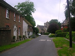
Originally Glynde lay within the 1530-acre (619 ha) Glynde parish, which was united with West Firle and Beddingham after the Second World War, to form Glynde and Beddingham.[4] However, it is still a separate civil parish.
The rectory of Glynde was held by the Abbots of Bec in Normandy from the Norman Conquest to Agincourt (1415). Henry V's brother, the Duke of Bedford, confiscated it and transferred it to the Dean and Chapter of Windsor (1421). They remain patrons to the living to this day.[4]
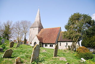
The present parish church of St Mary the Virgin, built by Richard Trevor to a design by Sir Thomas Robinson, was dedicated in 1765.[6] The old parish church which it replaced appears to have been similar to many churches in the district, having nave, north aisle, and chancel, with south porch.[7] The new church, in Palladian style, was faced in Sussex flints and lightened with windows of coloured lozenges of Flemish glass; these were taken out in the 19th century, but some of the glass remains in windows in Glynde Place.[4]
The war memorial, with the names of seventeen men of Glynde who fell in the two world wars, is of Portland stone and stands at the bottom of the churchyard, close to the road.[4]
The village was the home of Field Marshal Garnet, Viscount Wolesley (1833–1913) Commander-in-Chief of the British Army from the 1890s until his death in 1913.
Transport
Roads
Glynde was once on the turnpike between Lewes and Eastbourne. The turnpike road was constituted by the Glynde Bridge Turnpike Act. It is now Ranscombe Lane. It was not a financial success. In 1817, with its act due to expire in 1821 and the works incomplete, a new turnpike was sponsored to cut across the marshes of Beddingham. This cut 7 miles (11km) from the journey from Lewes to Eastbourne. The new turnpike road is – broadly – the modern A27. Glynde lies to the north of that road.[4]
The railway arrived in 1846. The station was built on the then parish boundary between Glynde and Beddingham. The railway was electrified in 1935.
There were three industrial lines connected to Glynde station:[8]
Balcombe Pit was connected to the railway at the eastern end of Glynde station.
A tramway to Brigden Pit was connected to the western end of Glynde station.
A clay pit was connected to the eastern end of the station, first by a telpherage line, then by a tramway.
The Glynde telpherage line was built by the Telpherage Company and was opened on Saturday 17 October 1885. Reports of the new system were published as far afield as the New York Times.[9] It was said to cost £1,200, including the equipment to generate electricity, the trains, and the locomotives. The electricity was generated by a dynamo which was powered by a steam engine. The water for the engine was apparently raised by a windmill at the station end of the line. The line extended for almost a mile. It was a double line of steel rods 66 feet (20m) long and with a 0.75-inch (19mm) diameter. The rods were elevated 18 feet (5.5m) above the ground on posts. The locomotive and skips were suspended from pulleys that ran on the rods. A train of ten skips could carry a ton of clay."[8]
Frances Garnet Wolseley founded the influential Glynde College for Lady Gardeners at Trevor House, Glynde in 1899. It continued to offer two-year courses at Ragged Lands from 1902 until about 1933.[10]
Lime
Chalk pits are long standing features in the area, used for liming the fields, mending the roads, and occasionally making mortar for building. Transportation by road was prohibitively expensive, so the pits had minimal commercial value.[11]
Then in 1846 the railway came and Henry Otway Trevor immediately leased all the chalk pits in Glynde and Beddingham to a Lewes limeburning partnership. Three pits were named: Glyndebourne, Brigden, and Balcombe (also known as Poor or Newington). The procedure was to excavate the chalk, turn it into lime in large kilns, and transport it away by rail to be used as cement. The kilns were coal-fired; much of the coal was shipped by barge up Glynde Reach to the wharves at Glynde Bridge. The work in the chalk pits was labour-intensive, with over a hundred men employed in the pits at their peak.[11]
Clay
A clay pit was opened in 1885 north of Glynde Reach, to the east of Decoy Wood. The pit was to supply Gault clay to the new Sussex Portland Cement works at South Heighton. Both were on land leased from the Glynde Estate for 99 years. In the event, the clay pit was only worked for around 30 years. Initially the clay was transported via a telpherage line to Glynde station, latterly (by the late 1890s) via a tramway.[8]
Power
The lack of fast-moving water has prevented the production of power by water mills. Instead, a number of windmills have been built.[12]
In the 16th and 17th centuries there was a windmill on an old burial mound just above and to the west of Speaker's Holt on the crest of the Downs. This was no longer in operation by 1717. Apparently even the mound has now been bulldozed.
A Glyndebourne estate windmill lay within Ringmer parish, on Mill Plain, just above Glyndebourne.
Edward Elphick erected a windmill that stood from 1806 to 1867, located on the Balcombe lands that were eventually swallowed up by the chalk pit. When the mill stood in the way of the pit's expansion, it was dismantled and moved to Blackboys. Its operation there ceased in 1937 and it was demolished in 1945.
When Elphick's windmill was dismantled in 1867, the local farmers transferred their custom to the new steam mill built between Glynde station and Glynde Reach.[12]
Economy and tourism
Glynde
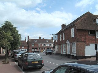
Glynde has an unusually large number of businesses for a small English village. In addition to the usual village shop, there is a staircase manufacturer in the old steam mill and a weighing equipment manufacturer in the old granary.
Glynde has several tourist attractions. Many tourists are people walking on the South Downs; Glynde sits on the flank of Mount Caburn. The Elizabethan manor house, Glynde Place, is open to the public. Other facilities for visitors include a teashop, a forge, and a paragliding and hang-gliding centre. North of the village is Glyndebourne, where opera is performed. The village has a total of 27 listed buildings by Historic England, including Glynde Place, a Grade 1 Listed Building.[13]
The Trevor Arms was a pub in the village, near the station, but it closed in January 2017.[14]
East Sussex is a ceremonial county in South East England. It is bordered by Kent to the north-east, West Sussex to the west, Surrey to the north-west, and the English Channel to the south. The largest settlement is the city of Brighton and Hove, and the county town is Lewes.
Lewes is the county town of East Sussex, England. The town is the administrative centre of the wider district of the same name and the location of East Sussex County Council at the county hall.
The Ouse is a 35 miles long river in the English counties of West and East Sussex. It rises near Lower Beeding in West Sussex, and flows eastwards and then southwards to reach the sea at Newhaven. It skirts Haywards Heath and passes through Lewes. It forms the main spine of an extensive network of smaller streams, of which the River Uck is the main tributary. As it nears the coast it passes through the Lewes and Laughton Levels, an area of flat, low-lying land that borders the river and another tributary, the Glynde Reach. It was a large tidal inlet at the time of the Domesday book in 1086, but over the following centuries, some attempts were made to reclaim some of the valley floor for agriculture, by building embankments, but the drainage was hampered by the buildup of a large shingle bar which formed across the mouth of the river by longshore drift.
Rodmell is a small village and civil parish in the Lewes District of East Sussex, England. It is located three miles (4.8 km) south-east of Lewes, on the Lewes to Newhaven road and six and a half miles from the City of Brighton & Hove and is situated by the west banks of the River Ouse. The village is served by Southease railway station, opened in 1906. The Prime Meridian passes just to the west of the village.
Polegate is a town and civil parish in the Wealden District of East Sussex, England, United Kingdom. It is located five miles (8 km) north of the seaside resort of Eastbourne and is part of the greater area of that town. Although once a railway settlement, its rail links were closed as part of the Beeching cuts. The 2011 census put the civil parish of Polegate at a population of 8,586, with 41.2% aged 65 and over.
Isfield is a small village and civil parish in the Wealden District of East Sussex in England, located north-east of Lewes.
The East Coastway line is a railway line along the south coast of Sussex to the east of Brighton, England. Trains to the west of Brighton operate on the West Coastway line. Together with the West Coastway and the Marshlink line to the east, the line forms part of a continuous route from Havant to Ashford. The Brighton Main Line route to Eastbourne and Hastings, via Plumpton and Cooksbridge, shares the East Coastway line east of Lewes station.
Hassocks is a village and civil parish in the Mid Sussex District of West Sussex, England. Its name is believed to derive from the tufts of grass found in the surrounding fields.
Glynde railway station serves Glynde in East Sussex. It is 53 miles 11 chains (85.5 km) from London Bridge, on the East Coastway Line and train services are provided by Southern.
Glynde and Beddingham Parish Council is a combined council of two civil parishes in the Lewes district of East Sussex.
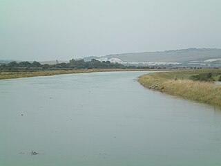
Mount Caburn is a 150-metre prominent landmark in East Sussex, England, about one mile (1.6 km) east of Lewes overlooking the village of Glynde. It is the highest part of an outlier of the South Downs, separated from the main range by Glynde Reach, a tributary of the River Ouse.
Ardingly is an English village and civil parish in the Mid Sussex district of West Sussex, England. The village is in the High Weald Area of Outstanding Natural Beauty about 33 miles (53 km) south of London and 33 miles (53 km) east-north-east of the county town of Chichester. The parish covers an area of 3,974 acres (1,608 ha). The 2011 Census recorded a population of 1,936 an increase from 1,833 in 2001.
Berwick is a village and civil parish in the Wealden district of East Sussex in England. The village lies immediately to the south of the A27 road between Lewes and Polegate, about three miles (4.8 km) west of the latter. The parish is located in the River Cuckmere floodplain, north of the South Downs.
Blackthorn is a village and civil parish in the Cherwell District of Oxfordshire about 3 miles (5 km) southeast of Bicester. The parish is bounded by the River Ray to the south, tributaries of the Ray to the east and north and field boundaries to the west. The parish's eastern boundary forms part of the county's with Buckinghamshire.
Rotherfield is a village and civil parish in the Wealden District of East Sussex, England. It is one of the largest parishes in East Sussex. There are three villages in the parish: Rotherfield, Mark Cross and Eridge. The River Rother, which drains much of the county and discharges at Rye Harbour, has its source on the south side of the hill on which Rotherfield village is built.
Hamsey is a village and civil parish in the Lewes district of East Sussex, England. The parish covers a large area and also consists of the villages Offham and Cooksbridge. The main centres of population in the parish are now Offham and Cooksbridge. Around the main settlements are enlarged fields, isolated old cottages and farms. The winding and undulating parish lanes between banks, old hedge rows, trees, flowery verges and ditches are popular with cyclists and give good views of the Downs. In 2011 the parish had a population of 632.
Plumpton is a village and civil parish in the Lewes District of East Sussex, England. The village is located five miles (8 km) north-west of Lewes. The parish measures 6.5 miles in length on its north–south axis and 1 mile at its widest on the B2116 Underhill Road. The southern half of the parish lies within the South Downs National Park and at the highest point, 214m (702 feet), the South Downs Way traverses the crest of Plumpton Plain. The parish includes the small village of Plumpton adjacent to the Downs and to the north the larger village of Plumpton Green where most of the community and services are based. Plumpton is known for its race course, and also Plumpton College, which farms over 2500 acres of land and has become one of the leading centres for land-based education in the UK.
Anthony David Brand, 6th Viscount Hampden DL was a British stock broker, Sussex land owner, South Downsman, hereditary peer and land agent.
Beddingham is an English village and civil parish in the Lewes district of East Sussex, at the junction between the London–Newhaven (A26) and south coast (A27) roads south-east of Lewes. The parish council joined with that of Glynde shortly after the Second World War, as Glynde and Beddingham, but they remain separate civil parishes.
Hangleton Manor Inn, the adjoining Old Manor House and associated buildings form a bar and restaurant complex in Hangleton, an ancient village which is part of the English city of Brighton and Hove. The manor house is the oldest secular building in the Hove part of the city; some 15th-century features remain, and there has been little change since the High Sheriff of Sussex rebuilt it in the mid-16th century. Local folklore asserts that a 17th-century dovecote in the grounds has been haunted since a monk placed a curse on it. The buildings that comprise the inn were acquired by Hangleton Manor Ltd in 1968, and converted to an inn under the Whitbread banner. The brewery company Hall & Woodhouse have owned and operated it since 2005. English Heritage has listed the complex at Grade II* for its architectural and historical importance, and the dovecote is listed separately at Grade II.
This page is based on this Wikipedia article Text is available under the CC BY-SA 4.0 license; additional terms may apply. Images, videos and audio are available under their respective licenses.