Ringmer

Last updated • 3 min readFrom Wikipedia, The Free Encyclopedia

Ringmer
Village and civil parish
Ringmer Village Hall - geograph.org.uk - 1428252.jpg
East Sussex UK location map.svg
Red pog.svg
Ringmer
Location within East Sussex
Area25.9 km2 (10.0 sq mi)  [1]
Population4,648 (Parish-2011) [2]
  Density 459/sq mi (177/km2)
OS grid reference TQ445124
  London 43 miles (69 km) N
District
Shire county
Region
Country England
Sovereign state United Kingdom
Post town LEWES
Postcode district BN8
Dialling code 01273
Police Sussex
Fire East Sussex
Ambulance South East Coast
UK Parliament
Website Parish Council website
List of places
UK
England
East Sussex
50°53′N0°03′E / 50.89°N 0.05°E / 50.89; 0.05

Ringmer is a village and civil parish in the Lewes District of East Sussex, England. [3] The village is 3 miles (4.8 km) east of Lewes. Other small settlements in the parish include Upper Wellingham, Ashton Green, Broyle Side, Norlington, Little Norlington and Shortgate.

Contents

Description

Ringmer is one of the largest villages in Southern England. [4] There has been human habitation since at least Roman times. [5] The parish church, dedicated to St Mary, was probably built in the 13th century. [6] One of its rectors, named to the living in 1533, was William Levett, named in the same year as rector of Buxted, and one of the most improbable figures in English ecclesiastical history. [7]

Ringmer has two schools, Ringmer Primary School for ages 4–11 and King's Academy (formerly Ringmer Community College) for students aged 11–18.

Ringmer village sign (south face) Ringmer Village sign (south face).jpg
Ringmer village sign (south face)

The symbol of Ringmer is a tortoise named Timothy, after the female tortoise that the naturalist Gilbert White carried back to Selborne in Hampshire in 1780. [8] White’s aunt Rebecca Snooke lived in Delves House where Timothy had the run of the courtyard garden. Timothy died in 1794, a year after White.

Governance

Ringmer is part of the Lewes District Council electoral ward of Ouse Valley and Ringmer. The population of this ward at the 2011 census was 6,422. [9] It is in the Ringmer and Lewes Bridge Division of East Sussex County Council.

The UK Parliament constituency for Ringmer is Lewes. The Liberal Democrat Norman Baker served as the constituency MP from 1997 until 2015, when Conservative Maria Caulfield was elected. As of July 2024 Liberal Democrat James MacCleary is the MP.

Prior to Brexit in 2020, Ringmer was part of the South East England constituency in the European Parliament.

Landmarks

Ringmer Mill stood for centuries on Mill Plain overlooking Ringmer. This post mill was in operation until 1921 but collapsed in 1925 leaving the mill post, on which the body of the mill rotated, standing as a local landmark.

Plashett Park Wood is a Site of Special Scientific Interest partly in the parish. It is a site of biological importance as an area of ancient woodland. Plashett Wood and the adjoining Plashett Park Farm provide habitats for a wide variety of breeding birds and bats, and a number of rarer invertebrates and flora. [10]

Sport and leisure

Ringmer has a Non-League football club, AFC Ringmer, which played at The Caburn ground until 2020; from season 2020/21 games are played at a new ground behind King's Academy.

Notable residents

2006 fireworks factory fire

The mushroom cloud from the fire at the factory Festivalfireworks.JPG
The mushroom cloud from the fire at the factory

On 3 December 2006 the Festival Fireworks factory, which is in the parish near Shortgate, caught fire detonating the display pyrotechnics stored on the site. Successive explosions then followed for more than eight hours. Sussex Police, which described it as "a serious incident", established a 200 metres (660 ft) exclusion zone around the factory. Television pictures showed a large fireball at the centre of the blaze. Two members of Sussex fire services died and nine fire service workers were injured, along with two members of the public and two police officers. Hundreds of rockets continued to explode more than five hours after the initial blasts. [13]

Related Research Articles

<span class="mw-page-title-main">Newhaven</span> Port town in East Sussex, England

Newhaven is a port town in the Lewes district of East Sussex, England, lying at the mouth of the River Ouse.

<span class="mw-page-title-main">Rodmell</span> Village and parish in East Sussex, England

Rodmell is a small village and civil parish in the Lewes District of East Sussex, England. It is located three miles (4.8 km) south-east of Lewes, on the Lewes to Newhaven road and six and a half miles from the City of Brighton & Hove and is situated by the west banks of the River Ouse. The village is served by Southease railway station, opened in 1906. The Prime Meridian passes just to the west of the village.

<span class="mw-page-title-main">Isfield</span> Village and parish in East Sussex, England

Isfield is a small village and civil parish in the Wealden District of East Sussex in England, located north-east of Lewes.

<span class="mw-page-title-main">Burwash</span> Village and parish in East Sussex, England

Burwash, archaically known as Burghersh, is a rural village and civil parish in the Rother district of East Sussex, England. Situated in the High Weald of Sussex some 15 miles (24 km) inland from the port of Hastings, it is located five miles (8 km) south-west of Hurst Green, on the A265 road, and on the River Dudwell, a tributary of the River Rother. In an area steeped in history, some nine miles (14 km) to the south-east lies Battle Abbey and eight miles (13 km) to the east is Bodiam Castle.

<span class="mw-page-title-main">Lewes (UK Parliament constituency)</span> Parliamentary constituency in the United Kingdom, 1868 onwards

Lewes is a constituency in East Sussex represented in the House of Commons of the UK Parliament since 2024 by James MacCleary, a Liberal Democrat.

<span class="mw-page-title-main">Glynde and Beddingham</span> Parish in East Sussex, England

Glynde and Beddingham Parish Council is a combined council of two civil parishes in the Lewes district of East Sussex.

<span class="mw-page-title-main">Firle</span> Village in East Sussex, England

Firle is a village and civil parish in the Lewes district of East Sussex, England. Firle refers to an Old English word fierol meaning overgrown with oak.

<span class="mw-page-title-main">Barcombe</span> Village and parish in East Sussex, England

Barcombe is an East Sussex village and civil parish in the Lewes District of East Sussex. The parish has four settlements: old Barcombe, the oldest settlement in the parish with the parish church; Barcombe Cross, the more populous settlement and main hub with the amenities and services; the hamlet of Spithurst in the northeast and Town Littleworth in the northwest.

<span class="mw-page-title-main">East Hoathly with Halland</span> Parish in East Sussex, England

East Hoathly with Halland is a civil parish in the Wealden District of East Sussex, England. The parish contains the two villages of East Hoathly and Halland, two miles (3.2 km) to the west; it sits astride the A22 road, six miles (9.6 km) north-west of Hailsham, although the original sharp bend on that road through East Hoathly has now been bypassed. On 1 April 2000 the parish was renamed from "East Hoathly" to "East Hoathly with Halland".

<span class="mw-page-title-main">Southease</span> Village and parish in East Sussex, England

Southease is a small village and civil parish in East Sussex, in South East England between the A26 road and the C7 road from Lewes to Newhaven. The village is to the west of the River Ouse, Sussex and has a church dedicated to Saint Peter. Southease railway station lies roughly a kilometre east over the river and may be reached via a swing bridge.

<span class="mw-page-title-main">Little Horsted</span> Village in East Sussex, England

Little Horsted is a village and civil parish in the Wealden district of East Sussex, England. It is located two miles (3.2 km) south of Uckfield, on the A26 road.

<span class="mw-page-title-main">Piddinghoe</span> Village and parish in East Sussex, England

Piddinghoe is a village and civil parish in the Lewes District of East Sussex, England. It is located in the valley of the River Ouse between Lewes and Newhaven, five miles (8 km) south of the former, downstream of Southease.

<span class="mw-page-title-main">Selmeston</span> Village in East Sussex, England

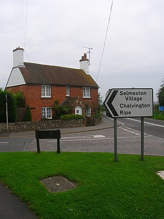
Selmeston is a village and civil parish in the Wealden District of East Sussex, England. It is located eight miles (13 km) east of Lewes, to the north of the A27 road between there and Polegate.

<span class="mw-page-title-main">East Chiltington</span> Village in East Sussex, England

East Chiltington is a village and civil parish in the Lewes District of East Sussex, England. It is centred four miles (5.9 km) south-east of Burgess Hill and five miles (8 km) north-west of Lewes. It is a strip parish of 3.76 square miles (9.7 km2), stretching northward from the crest of the South Downs. The village church is 13th century in origin; the vicar also has charge of two churches in Plumpton. Near the church there is a pub called The Jolly Sportsman. The Sussex Greensand Way, a Roman road, runs from east to west through the centre of the parish.

<span class="mw-page-title-main">Hamsey</span> Village and parish in East Sussex, England

Hamsey is a village and civil parish in the Lewes district of East Sussex, England. The parish covers a large area and also consists of the villages Offham and Cooksbridge. The main centres of population in the parish are now Offham and Cooksbridge. Around the main settlements are enlarged fields, isolated old cottages and farms. The winding and undulating parish lanes between banks, old hedge rows, trees, flowery verges and ditches are popular with cyclists and give good views of the Downs. In 2011 the parish had a population of 632.

<span class="mw-page-title-main">Iford, East Sussex</span> Village and parish in East Sussex, England

Iford is a village and civil parish in the Lewes District of East Sussex, England. The village is located two miles (3.2 km) south of Lewes. The parish lies on the slopes of the South Downs in the valley of the River Ouse.

<span class="mw-page-title-main">Kingston near Lewes</span> Village and parish in East Sussex, England

Kingston near Lewes is a village and civil parish in the Lewes District of East Sussex, England. The village is mentioned in the Domesday Book and is located two miles (3.2 km) south of Lewes and is nestled in the South Downs. The parish is par of two Sites of Special Scientific Interest: the Lewes Brooks and Kingston Escarpment and Iford Hill.

<span class="mw-page-title-main">South Heighton</span> Suburb of Newhaven, Sussex, England

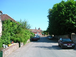
South Heighton is a village and civil parish in the Lewes District of East Sussex, England. The village is seven miles (12 km) south of Lewes. In the 1890s the village's population grew from less than 100 to over 500 after a cement manufacturing plant opened nearby. The village is now associated with the urbanised area of Newhaven.

<span class="mw-page-title-main">Tarring Neville</span> Village and civil parish in East Sussex, England

Tarring Neville is a village and civil parish in the Lewes district of East Sussex, England. The village is located five miles (8 km) south of Lewes, on the A26 road to Newhaven. The south west border of the parish runs along the River Ouse, the parish extending into the South Downs. In 1971 the parish had a population of 36.

References

  1. "East Sussex in Figures". East Sussex County Council. Retrieved 26 April 2008.
  2. "Civil parish population 2011" . Retrieved 12 October 2015.
  3. OS Explorer map Eastbourne and Beachy Head Scale: 1:25 000. Publisher:Ordnance Survey – Southampton B2 edition. Publishing Date:2009. ISBN   978 0319240823
  4. "Archived copy" (PDF). Archived from the original (PDF) on 4 March 2016. Retrieved 7 January 2015.{{cite web}}: CS1 maint: archived copy as title (link)
  5. "Ringmer - Tourist Information on the towns and villages in Sussex". Archived from the original on 8 January 2015. Retrieved 7 January 2015.
  6. "Home". ringmerchurch.org.uk.
  7. Dunkin, Edwin Hadlow W. (1875). "Contributions towards the Ecclesiastical History of the Deanery of South Malling". Sussex Archaeological Collections. 26: 73. doi: 10.5284/1085488 .
  8. "Ringmer East Sussex - (Poor Roads and riots) and English Village UK". Archived from the original on 8 January 2015. Retrieved 7 January 2015.
  9. "Ouse Valley and Ringmer Ward population 2011" . Retrieved 12 October 2015.
  10. "SSSI Citation Plashett Park Wood" (PDF). Natural England. Retrieved 12 October 2008.
  11. "Lady Callaghan of Cardiff". The Independent. London. 30 March 2005.[ dead link ]
  12. "Obituary: Lord Callaghan". BBC News. 26 March 2005.
  13. "Fireworks depot blaze kills two". BBC Southern Counties News. BBC. 3 December 2006. Retrieved 20 July 2008.

Commons-logo.svg Media related to Ringmer at Wikimedia Commons