West Sussex is a ceremonial county in South East England. It is bordered by Surrey to the north, East Sussex to the east, the English Channel to the south, and Hampshire to the west. The largest settlement is Crawley, and the county town is the city of Chichester.

West Green is one of the 14 residential neighbourhoods in Crawley, a town and borough in West Sussex, England. Crawley was planned and laid out as a New Town after the Second World War, based on the principle of self-contained neighbourhoods surrounding a town centre of civic and commercial buildings. West Green was the first neighbourhood to be developed, and is one of the smallest and closest to the town centre.

A rape is a traditional territorial sub-division of the county of Sussex in England, formerly used for various administrative purposes. Their origin is unknown, but they appear to predate the Norman Conquest. Historically the rapes formed the basis of local government in Sussex.
Sussex, from the Old English 'Sūþsēaxe', is a historic county in South East England.

West Sussex County Council (WSCC) is the authority that governs the non-metropolitan county of West Sussex. The county also contains seven district and borough councils, and 158 town, parish and neighbourhood councils. The county council has 70 elected councillors. The Chief Executive and their team of Directors are responsible for the day-to-day running of the council.

St John the Baptist's Church is an Anglican church in Crawley, West Sussex, England. It is the parish church of Crawley, and is the oldest building in the town centre, dating from the 1250—although many alterations have been made since, and only one wall remains of the ancient building. In September 2017, a team from St Peter's Brighton began a new phase in the life of St John's Crawley. St John's offer a variety of services, traditional and informal, and contemporary services.

St Mary de Haura Church is an Anglican church in the ancient "New Shoreham" area of Shoreham-by-Sea in the district of Adur, one of seven local government districts in the English county of West Sussex. It was founded at the end of the 11th century as a large cruciform church which, due to its original scale, has been described as a collegiate church—a reflection of the port of Shoreham's importance at the time. The former east end of that building survives to form the present church, and much 12th-century work remains. It functions as Shoreham-by-Sea's "town church" for major religious and social events, as well as serving as the town-centre parish. English Heritage has listed it at Grade I for its architectural and historical importance.
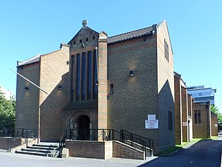
The Friary Church of St Francis and St Anthony is a Roman Catholic church in Crawley, a town and borough in West Sussex, England. The town's first permanent place of Roman Catholic worship was founded in 1861 next to a friary whose members, from the Order of Friars Minor Capuchin, had been invited to the area by a wealthy local family of Catholic converts. Crawley's transformation from a modest market town to a rapidly growing postwar New Town in the mid-20th century made a larger church necessary, and in the late 1950s the ecclesiastical architect Harry Stuart Goodhart-Rendel was commissioned to build a new church. The friary closed in 1980 and has been demolished, but the large brick church still stands in a commanding position facing the town centre. English Heritage has listed the building at Grade II for its architectural and historical importance.

The Rape of Lewes is one of the rapes, the traditional sub-divisions unique to the historic county of Sussex in England.
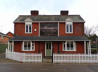
As of November 2010, there were 59 locally listed buildings in Crawley, a town and borough in the county of West Sussex in southeast England. One of these has subsequently been demolished. A locally listed building is defined as "a building, structure or feature that, whilst not statutorily listed by the Secretary of State, the Council considers to be an important part of Crawley's heritage due to its architectural, historic or archaeological significance". Crawley Borough Council administers the selection and deselection process, defines the criteria for inclusion, and produces and updates the local list.
Religion in Sussex has been dominated over the last 1,400 years by Christianity. Like the rest of England, the established church in Sussex is the Church of England, although other Christian traditions exist. After Christianity, the religion with the most adherents is Islam, followed by Hinduism, Buddhism, Judaism and Sikhism.
The history of Christianity in Sussex includes all aspects of the Christianity in the region that is now Sussex from its introduction to the present day. Christianity is the most commonly practised religion in Sussex.
The history of local government in Sussex is unique and complex. Founded as a kingdom in the 5th century, Sussex was annexed by the kingdom of Wessex in the 9th century, which after further developments became the Kingdom of England. It currently corresponds to two counties, East Sussex and West Sussex.
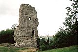
Sussex in the High Middle Ages includes the history of Sussex from the Norman Conquest in 1066 until the death of King John, considered by some to be the last of the Angevin kings of England, in 1216. It was during the Norman period that Sussex achieved its greatest importance in comparison with other English counties. Throughout the High Middle Ages, Sussex was on the main route between England and Normandy, and the lands of the Anglo-Norman nobility in what is now western France. The growth in Sussex's population, the importance of its ports and the increased colonisation of the Weald were all part of changes as significant to Sussex as those brought by the neolithic period, by the Romans and the Saxons. Sussex also experienced the most radical and thorough reorganisation of land in England, as the Normans divided the county into five tracts of lands called rapes. Although Sussex may have been divided into rapes earlier in its history, under the Normans they were clearly administrative and fiscal units. Before the Norman Conquest Sussex had the greatest concentration of lands belonging to the family of Earl Godwin. To protect against rebellion or invasion, the scattered Saxon estates in Sussex were consolidated into the rapes as part of William the Conqueror's 'Channel march'.