
The Kingdom of the South Saxons, today referred to as the Kingdom of Sussex, was one of the seven traditional kingdoms of the Heptarchy of Anglo-Saxon England. On the south coast of the island of Great Britain, it was originally a sixth-century Saxon colony and later an independent kingdom. The kingdom remains one of the least known of the Anglo-Saxon polities, with no surviving king-list, several local rulers and less centralisation than other Anglo-Saxon kingdoms. The South Saxons were ruled by the kings of Sussex until the country was annexed by Wessex, probably in 827, in the aftermath of the Battle of Ellendun.

East Sussex is a ceremonial county in South East England. It is bordered by Kent to the north-east, West Sussex to the west, Surrey to the north-west, and the English Channel to the south. The largest settlement is the city of Brighton and Hove, and the county town is Lewes.

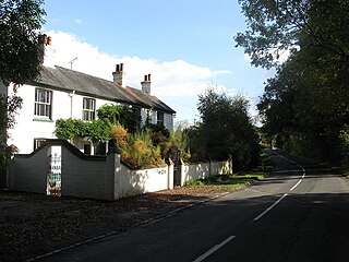
Rodmell is a small village and civil parish in the Lewes District of East Sussex, England. It is located three miles (4.8 km) south-west of Lewes, on the Lewes to Newhaven road and six and a half miles from the City of Brighton & Hove and is situated by the west banks of the River Ouse. The village is served by Southease railway station, opened in 1906. The Prime Meridian passes just to the west of the village.

The Adur is a river in Sussex, England; it gives its name to the Adur district of West Sussex. The river, which is 20 miles (32 km) long, was once navigable for large vessels up as far as Steyning, where there was a large Saxon port, but by the 11th century the lower river became silted up and the port moved down to the deeper waters at the mouth of the river in Shoreham-by-Sea.

A rape is a traditional territorial sub-division of the county of Sussex in England, formerly used for various administrative purposes. Their origin is unknown, but they appear to predate the Norman Conquest. Historically the rapes formed the basis of local government in Sussex.
Sussex, from the Old English 'Sūþsēaxe', is a historic county in South East England.

Ditchling is a village and civil parish in the Lewes District of East Sussex, England. The village is contained within the boundaries of the South Downs National Park; the order confirming the establishment of the park was signed in Ditchling.
Wivelsfield village and the larger adjacent village of Wivelsfield Green are the core of the civil parish of Wivelsfield in the Lewes District of East Sussex, England. The villages are 9.3 miles (15.0 km) north of the city of Brighton and Hove.

Westmeston is a village and civil parish in the Lewes District of East Sussex, England heavily dependent in amenities on larger Ditchling to the near-immediate northwest. It is four miles (6 km) south-southeast of Burgess Hill and (10 km) west of Lewes, on the northern slopes of the South Downs.
Kingston by Sea, also known as Kingston Buci, Kingston Bucii or simply Kingston, is a small area in the Adur district of West Sussex, England. Although it is now part of a continuous urban area, its origins lay in an ancient village and parish church between Southwick to the east, Shoreham-by-Sea to the west and the mouth of the River Adur to the south. St Julian's Church survives, and its parish perpetuates the ancient "Kingston Buci" name.

Lewes Priory is a part-demolished medieval Cluniac priory in Lewes, East Sussex in the United Kingdom. The ruins have been designated a Grade I listed building.
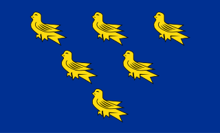
A heraldic shield has been associated with the historic county of Sussex since the seventeenth century. The device, displaying six martlets or heraldic swallows on a shield, later formed the basis of the flag of Sussex and the armorial bearings granted to the county councils of East and West Sussex.

Sussex is a historic county and cultural region in the south of England corresponding roughly in area to the ancient Kingdom of Sussex. It is bounded on the north by Surrey, north-east by Kent, south by the English Channel, and west by Hampshire, and is divided for local government into West Sussex and East Sussex and the city of Brighton and Hove. The city of Brighton & Hove was created a unitary authority in 1997, and was granted City status in 2000. Until then Chichester had been Sussex's only city. By convention, Chichester is Sussex's capital city and Lewes is Sussex's county town.

The Rape of Bramber is one of the rapes, the traditional sub-divisions unique to the historic county of Sussex in England. It is the smallest Sussex rape by area. Bramber is a former barony whose original seat was the castle of Bramber and its village, overlooking the river Adur.

Erringham chapel is a former place of worship in the deserted medieval village of Old Erringham, north of Shoreham-by-Sea in the district of Adur, one of seven local government districts in the English county of West Sussex. Founded in the 11th century as a chapel of ease to St Nicolas' Church in the Saxon riverside village of Old Shoreham, it was in use for several centuries until depopulation caused Old Erringham to become unviable as a settlement. The chapel fell into ruin, and its remains have been incorporated into a barn on the farm which now occupies the site of the village. English Heritage has listed the remaining structure at Grade II for its architectural and historical importance.
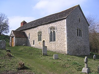
Coombes Church is a Church of England parish church in the rural hamlet of Coombes in the Adur District of West Sussex, England. It has served the rural parish, northwest of Shoreham-by-Sea and next to the River Adur, since the 11th century. Despite several re-buildings, some structural elements remain from that period. An important series of wall paintings, dating from the 12th to the 18th century, were uncovered in 1949. English Heritage has listed the church at Grade I for its architectural and historical importance.

Southover General Baptist Chapel is a former Baptist place of worship in the ancient village of Southover, now part of the town and district of Lewes, one of six local government districts in the English county of East Sussex. Founded in 1741 as the first Baptist place of worship in the area, it attracted a congregation of General Baptists whose theological views gradually moved towards Unitarianism. This led to their union with the members of the nearby Westgate Chapel, after which the flint and brick building housed other congregations and secular groups before its conversion to a house. The building is protected as a Grade II by English Heritage.
The history of local government in Sussex is unique and complex. Founded as a kingdom in the 5th century, Sussex was annexed by the kingdom of Wessex in the 9th century, which after further developments became the Kingdom of England. It currently corresponds to two counties, East Sussex and West Sussex.
Sussex in the High Middle Ages includes the history of Sussex from the Norman Conquest in 1066 until the death of King John, considered by some to be the last of the Angevin kings of England, in 1216. It was during the Norman period that Sussex achieved its greatest importance in comparison with other English counties. Throughout the High Middle Ages, Sussex was on the main route between England and Normandy, and the lands of the Anglo-Norman nobility in what is now western France. The growth in Sussex's population, the importance of its ports and the increased colonisation of the Weald were all part of changes as significant to Sussex as those brought by the neolithic period, by the Romans and the Saxons. Sussex also experienced the most radical and thorough reorganisation of land in England, as the Normans divided the county into five tracts of lands called rapes. Although Sussex may have been divided into rapes earlier in its history, under the Normans they were clearly administrative and fiscal units. Before the Norman Conquest Sussex had the greatest concentration of lands belonging to the family of Earl Godwin. To protect against rebellion or invasion, the scattered Saxon estates in Sussex were consolidated into the rapes as part of William the Conqueror's 'Channel march'.

