Magnetic survey (archaeology)

Last updated
Magnetic survey of an archaeological site Mag survey g858grad.JPG
Magnetic survey of an archaeological site
Magnetic gradiometer map of Prehistoric fire-hearths 3030-mag.jpg
Magnetic gradiometer map of Prehistoric fire-hearths
A magnetic survey at Pembroke Castle carried out by Dyfed Archaeological Trust and funded by the Castle Studies Trust. [1]

Magnetic surveying is one of a number of methods used in archaeological geophysics. Magnetic surveys record spatial variation in the Earth's magnetic field. In archaeology, magnetic surveys are used to detect and map archaeological artefacts and features. Magnetic surveys are used in both terrestrial and marine archaeology.

Contents

Overview

Magnetometers used in geophysical survey may use a single sensor to measure the total magnetic field strength, or may use two (sometimes more) spatially separated sensors to measure the gradient of the magnetic field (the difference between the sensors). In most archaeological applications the latter (gradiometer) configuration is preferred because it provides better resolution of small, near-surface phenomena. Magnetometers may also use a variety of different sensor types. Proton precession magnetometers have largely been superseded by faster and more sensitive fluxgate and cesium instruments.

Every kind of material has unique magnetic properties, even those that we do not think of as being "magnetic". Different materials below the ground can cause local disturbances in the Earth's magnetic field that are detectable with sensitive magnetometers. The chief limitation of magnetometer survey is that subtle features of interest may be obscured by highly magnetic geologic or modern materials.

Magnetometry largely relies on the fact that the topsoil has a higher magnetic susceptibility than most bedrocks or subsoils. [2] This is because of the concentration of iron minerals in the topsoil, often weathered from the bedrock. Environmental processes such as repeated vegetation fires and redox reactions caused by wetting and drying of the soil convert iron compounds to oxide maghemite (y-Fe2O3). [3] Associated anthropogenic activities such as lighting fires or irrigated farming accentuate this effect.

Magnetometry is therefore useful for finding pits and ditches which have been backfilled with topsoil, with a higher magnetic susceptibility than the surroundings. [2] Roads and structures are also visible from magnetic surveys since they can be detected because the susceptibility of the subsoil material used in their construction is lower than the surrounding topsoil. [4]

Terrestrial magnetic surveys

In terrestrial archaeology, magnetic surveys are typically used for detailed mapping of archaeological features on known archaeological sites. More exceptionally, magnetometers are used for low-resolution exploratory surveys.

Several types of magnetometer are used in terrestrial archaeology. Early surveys, beginning in the 1950s, were conducted with proton precession magnetometers. Data collection with proton precession instruments was slow, making high sample density surveys impracticable. Data were manually recorded and plotted. The subsequent introduction of Fluxgate and cesium vapor magnetometers improved sensitivity, and greatly increased sampling speed, making high resolution surveys of large areas practical. Equally important was the development of computers to handle, process, and display large datasets. [5]

Magnetometers react very strongly to iron and steel, brick, burned soil, and many types of rock, and archaeological features composed of these materials are very detectable. Where these highly magnetic materials do not occur, it is often possible to detect very subtle anomalies caused by disturbed soils or decayed organic materials. Many types of sites and features have been successfully mapped with magnetometers, ranging from very ephemeral prehistoric campsites to large urban centers.

Magnetic survey help to prove that a survey area has the potential for more detailed studies and scientific excavation.

Marine magnetic surveys

Magnetic surveys are extremely useful in the excavation and exploration of underwater archaeological sites. The apparatus used on the water slightly differs from that on land. Marine magnetometers come in two types: surface-towed and near-bottom. Both are towed a sufficient distance (about two ship lengths) away from the ship to allow them to collect data without being affected by the ship's magnetic properties. Surface-towed magnetometers allow for a wider range of detection but have lower precision than near-bottom magnetometers. [6]

The most common type of magnetometer used for marine surveying is the fluxgate magnetometer. Fluxgate magnetometers utilize two ferromagnetic cores each wound with a primary coil (in opposite directions) and an outer secondary coil attached to an amp meter. When an alternating current (AC) is passed through the primary coils, it creates two opposing magnetic fields that vary in intensity based on the outside magnetic fields. [7] By floating them parallel to the seafloor, they can measure the changes in magnetic fields over the seabed.

Another common type is the newer proton precession magnetometer. This utilizes a container full of hydrogen-rich liquids (commonly kerosene or methanol) that, when agitated by a direct current (DC) or Radio Frequency (RF), cause the electrons to become energized and transfer that energy to the protons due to the Overhauser Effect, basically turning them into dipole magnets. When the stimulus is removed, the protons precess at a rate that can be interpreted to determine the magnetic forces of the area. [7]

In maritime archaeology, these are often used to map the geology of wreck sites and determine the composition of magnetic materials found on the seafloor. An Overhauser magnetometer (PPM) was used in 2001 to map Sebastos (the harbor of Caesarea Maritima) and helped to identify components of the Roman concrete. [8]

Airborne magnetic surveys

Measuring the Earths' magnetic field is a very useful tool in mineral exploration, oil exploration, and geological mapping. To cover large areas with uniform data, aircraft such as helicopters, airplanes, and drones are employed. The amount of detail is a function of flight height and sample density, in addition to instrument sensitivity. For surverys, drones are used which helps greatly in the process.

The magnetic properties of archaeological materials form the basis for a number of other archaeological techniques, Including:

Related Research Articles

<span class="mw-page-title-main">Magnetometer</span> Device that measures magnetism

A magnetometer is a device that measures magnetic field or magnetic dipole moment. Different types of magnetometers measure the direction, strength, or relative change of a magnetic field at a particular location. A compass is one such device, one that measures the direction of an ambient magnetic field, in this case, the Earth's magnetic field. Other magnetometers measure the magnetic dipole moment of a magnetic material such as a ferromagnet, for example by recording the effect of this magnetic dipole on the induced current in a coil.

<span class="mw-page-title-main">Archaeological site</span> Place in which evidence of past activity is preserved

An archaeological site is a place in which evidence of past activity is preserved, and which has been, or may be, investigated using the discipline of archaeology and represents a part of the archaeological record. Sites may range from those with few or no remains visible above ground, to buildings and other structures still in use.

<span class="mw-page-title-main">Geophysical survey (archaeology)</span> Non-invasive physical sensing techniques used for archaeological imaging or mapping

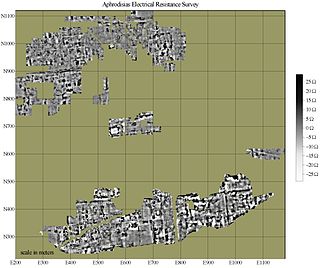
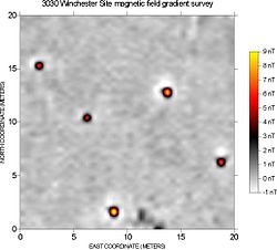
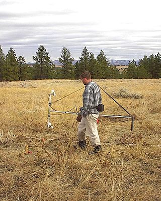
In archaeology, geophysical survey is ground-based physical sensing techniques used for archaeological imaging or mapping. Remote sensing and marine surveys are also used in archaeology, but are generally considered separate disciplines. Other terms, such as "geophysical prospection" and "archaeological geophysics" are generally synonymous.

<span class="mw-page-title-main">Proton magnetometer</span> Instrument which measures very small variations in the Earths magnetic field

A proton magnetometer, also known as a proton precession magnetometer (PPM), uses the principle of Earth's field nuclear magnetic resonance (EFNMR) to measure very small variations in the Earth's magnetic field, allowing ferrous objects on land and at sea to be detected.

<span class="mw-page-title-main">Geoarchaeology</span> Archaeological sub-discipline

Geoarchaeology is a multi-disciplinary approach which uses the techniques and subject matter of geography, geology, geophysics and other Earth sciences to examine topics which inform archaeological knowledge and thought. Geoarchaeologists study the natural physical processes that affect archaeological sites such as geomorphology, the formation of sites through geological processes and the effects on buried sites and artifacts post-deposition. Geoarchaeologists' work frequently involves studying soil and sediments as well as other geographical concepts to contribute an archaeological study. Geoarchaeologists may also use computer cartography, geographic information systems (GIS) and digital elevation models (DEM) in combination with disciplines from human and social sciences and earth sciences. Geoarchaeology is important to society because it informs archaeologists about the geomorphology of the soil, sediment, and rocks on the buried sites and artifacts they are researching. By doing this, scientists are able to locate ancient cities and artifacts and estimate by the quality of soil how "prehistoric" they really are. Geoarchaeology is considered a sub-field of environmental archaeology because soil can be altered by human behavior, which archaeologists are then able to study and reconstruct past landscapes and conditions.

Exploration geophysics is an applied branch of geophysics and economic geology, which uses physical methods at the surface of the Earth, such as seismic, gravitational, magnetic, electrical and electromagnetic, to measure the physical properties of the subsurface, along with the anomalies in those properties. It is most often used to detect or infer the presence and position of economically useful geological deposits, such as ore minerals; fossil fuels and other hydrocarbons; geothermal reservoirs; and groundwater reservoirs. It can also be used to detect the presence of unexploded ordnance.

<span class="mw-page-title-main">Magnetotellurics</span> Electromagnetic geophysical technique

Magnetotellurics (MT) is an electromagnetic geophysical method for inferring the earth's subsurface electrical conductivity from measurements of natural geomagnetic and geoelectric field variation at the Earth's surface.

<span class="mw-page-title-main">Ørsted (satellite)</span> Satellite

Ørsted is an Earth science satellite launched in 1999 to study the earth's geomagnetic field. It is Denmark's first satellite, named after Hans Christian Ørsted (1777–1851), a Danish physicist and professor at the University of Copenhagen, who discovered electromagnetism in 1820.

An inductive sensor is a device that uses the principle of electromagnetic induction to detect or measure objects. An inductor develops a magnetic field when an electric current flows through it; alternatively, a current will flow through a circuit containing an inductor when the magnetic field through it changes. This effect can be used to detect metallic objects that interact with a magnetic field. Non-metallic substances, such as liquids or some kinds of dirt, do not interact with the magnetic field, so an inductive sensor can operate in wet or dirty conditions.

Geophysical survey is the systematic collection of geophysical data for spatial studies. Detection and analysis of the geophysical signals forms the core of Geophysical signal processing. The magnetic and gravitational fields emanating from the Earth's interior hold essential information concerning seismic activities and the internal structure. Hence, detection and analysis of the electric and Magnetic fields is very crucial. As the Electromagnetic and gravitational waves are multi-dimensional signals, all the 1-D transformation techniques can be extended for the analysis of these signals as well. Hence this article also discusses multi-dimensional signal processing techniques.

<span class="mw-page-title-main">Aeromagnetic survey</span> Surveying method, analyzing the magnetic properties of large regions from high altitudes

An aeromagnetic survey is a common type of geophysical survey carried out using a magnetometer aboard or towed behind an aircraft. The principle is similar to a magnetic survey carried out with a hand-held magnetometer, but allows much larger areas of the Earth's surface to be covered quickly for regional reconnaissance. The aircraft typically flies in a grid-like pattern with height and line spacing determining the resolution of the data.

<span class="mw-page-title-main">Magnetic anomaly</span> Local variation in the Earths magnetic field

In geophysics, a magnetic anomaly is a local variation in the Earth's magnetic field resulting from variations in the chemistry or magnetism of the rocks. Mapping of variation over an area is valuable in detecting structures obscured by overlying material. The magnetic variation in successive bands of ocean floor parallel with mid-ocean ridges was important evidence for seafloor spreading, a concept central to the theory of plate tectonics.

<span class="mw-page-title-main">Spacecraft magnetometer</span>

Spacecraft magnetometers are magnetometers used aboard spacecraft and satellites, mostly for scientific investigations, plus attitude sensing. Magnetometers are among the most widely used scientific instruments in exploratory and observation satellites. These instruments were instrumental in mapping the Van Allen radiation belts around Earth after its discovery by Explorer 1, and have detailed the magnetic fields of the Earth, Moon, Sun, Mars, Venus and other planets and moons. There are ongoing missions using magnetometers, including attempts to define the shape and activity of Saturn's core.

<span class="mw-page-title-main">Gradiometer</span>

A gradiometer measures the gradient of a physical quantity, such as a magnetic field or gravity.

<span class="mw-page-title-main">Explorer 14</span> NASA satellite of the Explorer program

Explorer 14, also called EPE-B or Energetic Particles Explorer-B, was a NASA spacecraft instrumented to measure cosmic-ray particles, trapped particles, solar wind protons, and magnetospheric and interplanetary magnetic fields. It was the second of the S-3 series of spacecraft, which also included Explorer 12, 14, 15, and 26. It was launched on 2 October 1962, aboard a Thor-Delta launch vehicle.

<span class="mw-page-title-main">Near-surface geophysics</span> Geophysics of first tens of meters below surface

Near-surface geophysics is the use of geophysical methods to investigate small-scale features in the shallow subsurface. It is closely related to applied geophysics or exploration geophysics. Methods used include seismic refraction and reflection, gravity, magnetic, electric, and electromagnetic methods. Many of these methods were developed for oil and mineral exploration but are now used for a great variety of applications, including archaeology, environmental science, forensic science, military intelligence, geotechnical investigation, treasure hunting, and hydrogeology. In addition to the practical applications, near-surface geophysics includes the study of biogeochemical cycles.

<span class="mw-page-title-main">Forensic geophysics</span> Use of geophysics tools in forensic science

Forensic geophysics is a branch of forensic science and is the study, the search, the localization and the mapping of buried objects or elements beneath the soil or the water, using geophysics tools for legal purposes. There are various geophysical techniques for forensic investigations in which the targets are buried and have different dimensions. Geophysical methods have the potential to aid the search and the recovery of these targets because they can non-destructively and rapidly investigate large areas where a suspect, illegal burial or, in general, a forensic target is hidden in the subsoil. When in the subsurface there is a contrast of physical properties between a target and the material in which it is buried, it is possible to individuate and define precisely the concealing place of the searched target. It is also possible to recognize evidences of human soil occupation or excavation, both recent and older. Forensic geophysics is an evolving technique that is gaining popularity and prestige in law enforcement.

Geophysical signal analysis is concerned with the detection and a subsequent processing of signals. Any signal which is varying conveys valuable information. Hence to understand the information embedded in such signals, we need to 'detect' and 'extract data' from such quantities. Geophysical signals are of extreme importance to us as they are information bearing signals which carry data related to petroleum deposits beneath the surface and seismic data. Analysis of geophysical signals also offers us a qualitative insight into the possibility of occurrence of a natural calamity such as earthquakes or volcanic eruptions.

The Interior Characterization of Europa using Magnetometry (ICEMAG) is a multi-frequency magnetometer that was proposed to be flown on board the Europa Clipper mission to Jupiter's moon Europa, but its inclusion was cancelled in March 2019. Magnetic induction is a powerful tool for probing the subsurface and determine Europa's ocean depth, salinity, and ice shell thickness, as well as detecting erupting plume activity.

<span class="mw-page-title-main">FIELDS</span>

FIELDS is a science instrument on the Parker Solar Probe (PSP), designed to measure magnetic fields in the solar corona during its mission to study the Sun. It is one of four major investigations on board PSP, along with WISPR, ISOIS, and SWEAP. It features three magnetometers. FIELDS is planned to help answer an enduring questions about the Sun, such as why the solar corona is so hot compared to the surface of the Sun and why the solar wind is so fast.

References

  1. Ludlow, Neil (19 January 2017). "Geophysical survey at Pembroke Castle". Castle Studies Trust. Retrieved 27 April 2017.
  2. 1 2 Clark, Anthony J. (July 1986). "Archaeological geophysics in Britain". Geophysics. 51 (7): 1404–1413. Bibcode:1986Geop...51.1404C. doi:10.1190/1.1442189. ISSN   0016-8033.
  3. Le Borgne, E (1960). "Influence du feu sur le propriet´ es magn ´ etiques du sol et sur celles du schiste et du granite". Annales de Géophysique. 16: 159–195.
  4. Tite, M. S.; Mullins, C. (August 1971). "Enhancement of the Magnetic Susceptibility of Soils on Archaeological Sites". Archaeometry. 13 (2): 209–219. doi:10.1111/j.1475-4754.1971.tb00043.x. ISSN   0003-813X.
  5. Clark, Anthony J. (1996). Seeing Beneath the Soil. Prospecting Methods in Archaeology. London, United Kingdom: B.T. Batsford Ltd.
  6. "Marine Magnetometer." Ocean Instruments. Woods Hole Oceanographic Institution. http://www.whoi.edu/page.do?pid=8415&tid=3622&cid=14847
  7. 1 2 Boyd, Thomas M. "Measuring the Earth's Magnetic Field." Introduction to Geophysical Exploration. 30 June 1999. University of Melbourne. 9 May 2009 http://www.earthsci.unimelb.edu.au/ES304/index.html.
  8. Boyce, Joseph I., Eduard G. Reinhardt, Avner Raban, and Matthew R. Pozza. "Marine Magnetic Survey of a Submerged Roman Harbour, Caesarea Maritima, Israel." The International Journal of Nautical Archaeology 33 (2004): 122–36.

Further reading