Vattavada

Last updated

Vattavada
Village
Vattavada Valley.jpg
Farmlands at Vattavada village
India Kerala location map.svg
Red pog.svg
Vattavada
Location in Kerala, India
Coordinates: 10°11′0″N77°15′24″E / 10.18333°N 77.25667°E / 10.18333; 77.25667
CountryFlag of India.svg  India
State Kerala
District Idukki
Taluk Devikulam
Area
  Total31.78 km2 (12.27 sq mi)
Elevation
1,659 m (5,443 ft)
Population
 (2001)
  Total3,292
  Density100/km2 (270/sq mi)
Languages
  Official Malayalam, English [1]
  Regional Tamil [2] ,Malayalam
Time zone UTC+5:30 (IST)
PIN
685615
Telephone code04865
Vehicle registration KL-68
Sex ratio 955:1000 /
Literacy78%
Climate heavy cool (Köppen)

Vattavada is a village in Idukki district in the state of Kerala, bordering Tamil Nadu, India. [3] The village is located along Palani Hills in Western Ghats. It is an agricultural village known for growing a wide range of vegetables and fruits in the terrace farmlands. [4]

Contents

Demographics

As of 2011 Census, Vattavada had a population of 3,292 with 1,690 males and 1,602 females. Vattavada village has an area of 31.78 km2 (12.27 sq mi) with 901 families residing in it. In Vattavada, 12% of the population was under 6 years of age. Vattavada had an average literacy of 75.7% higher than the national average of 74% and lower than state average of 94%. [5]

Geography and climate

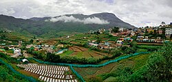
Vattavada is a virtually rain shadow village, lying in the eastern side of the Western Ghats near to Marayur and north side of Munnar. The region in and around Vattavada varies in height from 1,450 meters (4,760 ft) to 2,695 meters (8,842 ft) above mean sea level. Vattavada enjoys a salubrious climate. The temperature ranges between 5 °C (41 °F) and 20 °C (68 °F) in winter and 12 °C (54 °F) and 18 °C (64 °F) in summer. Temperatures as low as −4 °C (25 °F) have been recorded in the border region of Vattavada. [6] The mean maximum daily temperature is at its lowest during the monsoon months with the highest temperature being 19 °C (66 °F).

Crops

Vattavada is known as the market of Kerala, because they are in front of vegetable producing. Vattavada is famous for its wide variety of crops which is not seen on the other parts of Kerala, which includes varieties of apples, oranges, strawberries, guavas, pears, blackberries, plums, gooseberries, canistels, peaches and passion fruits, etc. Vattavada was also famous for cultivating wheat. But as the water content in the soil became less over the years due to large-scale cultivation of Eucalyptus, wheat cultivation has reduced significantly. [7]

Flora and fauna

Most of the native flora and fauna of Vattavada have disappeared due to severe habitat fragmentation resultant from the creation of the plantations. However, some species continue to survive and thrive in several protected areas nearby, including the new Kurinjimala Sanctuary to the east, the Chinnar Wildlife Sanctuary, Manjampatti Valley and the Amaravati reserve forest of Indira Gandhi Wildlife Sanctuary to the north east, the Eravikulam National Park and Anamudi Shola National Park to the north, the Pampadum Shola National Park to the south and the proposed Palani Hills National Park to the east. These protected areas are especially known for several threatened and endemic species including Nilgiri tahr, the grizzled giant squirrel, the Nilgiri wood-pigeon, elephant, the gaur, the Nilgiri langur, the sambar, and the neelakurinji (that blossoms only once in twelve years) and special thing is it center for Munnar, Kodaikanal and Marayur [8] [9]

Major Social and Political Events

On July 2, 2018, Abhimanyu belonging to Vattavada who was pursuing graduation in Maharajas College, Ernakulam was murdered by Campus Front of India activists over political rivalry. [10] [11] [12]

Related Research Articles

<span class="mw-page-title-main">Ooty</span> Hill station city in Tamil Nadu, India

Ooty, officially known as Udhagamandalam ; abbreviated as Udhagai), is a town and a municipality in the Nilgiris district of the Indian state of Tamil Nadu. It is located 86 km (53 mi) north west of Coimbatore and is the headquarters of the Nilgiris district. Located in the Nilgiri Hills, it is known as the "Queen of Hill Stations" and is a popular tourist destination.

<span class="mw-page-title-main">Western Ghats</span> Mountain range along the western coast of India

The Western Ghats, also known as the Sahyadri mountain range, is a mountain range that covers an area of 160,000 km2 (62,000 sq mi) in a stretch of 1,600 km (990 mi) parallel to the western coast of the Indian peninsula, traversing the states of Gujarat, Maharashtra, Goa, Karnataka, Kerala and Tamil Nadu. It is a UNESCO World Heritage Site and one of the 36 biodiversity hotspots in the world. It is sometimes called the Great Escarpment of India. It contains a very large proportion of the country's flora and fauna, many of which are endemic to this region. The Western Ghats are older than the Himalayas. They influence Indian monsoon weather patterns by intercepting the rain-laden monsoon winds that sweep in from the south-west during late summer. The range runs north to south along the western edge of the Deccan Plateau and separates the plateau from a narrow coastal plain called the Western Coastal Plains along the Arabian Sea. A total of 39 areas in the Western Ghats, including national parks, wildlife sanctuaries and reserve forests, were designated as world heritage sites in 2012 – twenty of them in Kerala, ten in Karnataka, six in Tamil Nadu and four in Maharashtra.

<span class="mw-page-title-main">Munnar</span> Town in Kerala, India

Munnar is a town and hill station located in the Idukki district of the southwestern Indian state of Kerala. Munnar is situated at around 1,600 metres (5,200 ft) above mean sea level, in the Western Ghats mountain range. Munnar is also called the "Kashmir of South India" and is a popular honeymoon destination.

<span class="mw-page-title-main">Idukki district</span> District in Kerala, India

Idukki is one of the 14 districts in the Indian state of Kerala in the southwest of the country. It is the largest district in Kerala and lies amid the Cardamom Hills of Western Ghats in Kerala. Idukki district contains two municipal towns - Kattappana and Thodupuzha, and five taluks.

<span class="mw-page-title-main">Nilgiri tahr</span> Species of mammal

The Nilgiri tahr is an ungulate that is endemic to the Nilgiri Hills and the southern portion of the Western and Eastern Ghats in the states of Tamil Nadu and Kerala in southern India. It is the only species in the genus Nilgiritragus and is closely related to the sheep of the genus Ovis.

<span class="mw-page-title-main">Thekkady</span> Hill station in Kerala, India

Thekkady is a town near Periyar National Park, an important tourist attraction in the Kerala state of India. The name Thekkady is derived from the word "thekku" which means teak. Temperatures are lowest in the months of December–January and highest in the months of April–May.

<span class="mw-page-title-main">Cardamom Hills</span> Mountain range in Kerala, India

The Cardamom Hills or Yela Mala are mountain range of southern India and part of the southern Western Ghats located in Idukki district, Kerala, India. Their name comes from the cardamom spice grown in much of the hills' cool elevation, which also supports pepper and coffee. The Western Ghats and Periyar Sub-Cluster including the Cardamom Hills are UNESCO World Heritage Sites.

<span class="mw-page-title-main">Palani Hills</span> Mountain range in India

The Palani Hills are a mountain range in the southern Indian states of Tamil Nadu and Kerala. The Palani Hills are an eastward extension of the Western Ghats ranges, which run parallel to the west coast of India. The Palani Hills adjoin with the high Anamalai range on the west and extend east into the plains of Tamil Nadu, covering an area of 2,068 square kilometres (798 sq mi). The highest part of the range is in the southwest, and reaches 1,800-2,500 metres elevation; the eastern extension of the range is made up of hills 1,000-1,500 m (3,281-4,921 ft) high.

<span class="mw-page-title-main">Anaimalai Hills</span> Mountain range in India

The Anamala or Anaimalai, also known as the Elephant Mountains, are a range of mountains in the southern Western Ghats of central Kerala and span the border of western Tamil Nadu in Southern India. The name anamala is derived from the Malayalam word aana and the Tamil word yaanai, meaning elephant, or from tribal languages. Mala or Malai means 'mountain', and thus literally translatable as 'Elephant mountain'.

<span class="mw-page-title-main">Marayur</span> Town in Kerala, India

Marayur or Marayoor is a town in Devikulam taluk of Idukki district in the southwestern Indian state of Kerala. It is located 42 kilometers north of Munnar on SH 17 connecting Munnar with Udumalpet, Tamil Nadu. Marayur is situated at around 1,600 metres above mean sea level and is the only place in Kerala that has natural sandalwood forests. Ancient dolmens and rock paintings in Marayur date back to the Stone Age. In 1991 Marayur had a population of 9,590.

<span class="mw-page-title-main">Eravikulam National Park</span> National park in India

Eravikulam National Park is a 97 km2 national park located along the Western Ghats in the Idukki and Ernakulam districts of Kerala in India. The park is situated between 10º05'N and 10º20' north, and 77º0' and 77º10' east and is the first national park in Kerala. It was established in 1978.

<i>Strobilanthes kunthiana</i> Species of shrub

Strobilanthes kunthiana, known as Kurinji or Neelakurinji in Tamil language and Malayalam and Gurige in Kannada, is a shrub of the bear's breeches family (Acanthaceae) that is found in the shola forests of the Western Ghats in Kerala, Karnataka and Tamil Nadu. The purplish blue flower blossoms only once in 12 years, and gave the Nilgiri Mountains range its name as nil (blue) + giri (mountains). The name Neelakurinji originates from the Malayalam language neela (blue) + kurinji (flower). Of all long interval bloomers Strobilanthes kunthiana is the most rigorously demonstrated, with documented bloomings in 1838, 1850, 1862, 1874, 1886, 1898, 1910, 1922, 1934, 1946, 1958, 1970, 1982, 1994, 2006 and 2018, these have no match to Solar cycles.

The Palani Hills Wildlife Sanctuary and National Park is a proposed protected area in Dindigul District, Tamil Nadu India. The park will be an upgrade and expansion of the 736.87 km2 (284.51 sq mi) Palani Kodaikanal Wildlife Sanctuary which was to be established in 2008. The park includes about 36% of the 2,068 km2 (798 sq mi) in the Palani Hills. The park is located between latitude 10°7'–10°28' N and longitude 77°16'–77°46' E. Central location is 1.5 kilometres (0.93 mi) east northeast of Silver Cascade Waterfall and 4 km (2.5 mi) E X NE of Kodaikanal Lake.

<span class="mw-page-title-main">Chinnar Wildlife Sanctuary</span> Wildlife sanctuary in South India

Chinnar Wildlife Sanctuary is located 18 km north of Marayoor on State Highway 17 in the Marayoor and Kanthalloor panchayats of Devikulam taluk in the Idukki district of India's Kerala state. It is one of 18 wildlife sanctuaries among the protected areas of Kerala.

<span class="mw-page-title-main">Kurinjimala Sanctuary</span>

Kurinjimala Sanctuary protects the approximately 32 hectare core habitat of the endangered Neelakurinji plant in the Kottakamboor and Vattavada villages in Devikulam Taluk, in the Idukki district of Kerala, a state in southern India.

<span class="mw-page-title-main">Anamudi Shola National Park</span> Protected area in Idukki district, Kerala, India

Anamudi Shola National Park is a protected area located along the Western Ghats of Idukki district in Kerala state, India. It is composed of Mannavan shola, Idivara shola and Pullardi shola, covering a total area of around 7.5 km². Draft notification of this new park was issued on 21 November 2003.

<span class="mw-page-title-main">Pampadum Shola National Park</span> National park in India

Pampadum Shola National Park is the smallest national park in Idukki district of Kerala in India. It is on the border with Kodaikanal, Dindigul district of Tamil Nadu. The park is administered by the Kerala Department of Forests and Wildlife, Munnar Wildlife Division, together with the nearby Mathikettan Shola National Park, Eravikulam National Park, Anamudi Shola National Park, Chinnar Wildlife Sanctuary and the Kurinjimala Sanctuary. The park adjoins the Allinagaram Reserved Forest within the proposed Palani Hills Wildlife Sanctuary and National Park.It is a part of Palani hills stretched up to Vandaravu peak. The Westerns Ghats, Anamalai Sub-Cluster, including these parks, is under consideration by the UNESCO World Heritage Committee for selection as a World Heritage Site.

<span class="mw-page-title-main">Vandaravu</span> Mountain in Tamil Nadu, India

Vandaravu is the highest peak in the Palani hills in Tamil Nadu, India.

<span class="mw-page-title-main">Kadavari</span> Village in Kerala, India

Kadavari is a village in the Vattavada panchayat of Devikulam taluk in Idukki district in Kerala, India. It is located close to the Tamil Nadu border at an elevation of around 2,000 m (6,600 ft) above sea level. The village is situated inside the Kurinjimala Sanctuary, a protected area for the Neelakurinji plant.

References

  1. "The Kerala Official Language (Legislation) Act, 1969" (PDF).
  2. "Table C-16 Population by Mother Tongue: Kerala". www.censusindia.gov.in. Registrar General and Census Commissioner of India.
  3. "Census of India: Villages with population 5000 & above". Registrar General & Census Commissioner, India. Archived from the original on 8 December 2008. Retrieved 10 December 2008.{{cite web}}: CS1 maint: others (link)
  4. "Why Vattavada is hailed as agricultural haven of Kerala". OnManorama. Retrieved 10 July 2023.
  5. Kerala, Directorate of Census Operations. District Census Handbook, Idukki (PDF). Thiruvananthapuram: Directorateof Census Operations,Kerala. p. 52,53. Retrieved 14 July 2020.
  6. Frost hits plantations in Vattavada.
  7. "Why Vattavada is hailed as agricultural haven of Kerala".
  8. Government of Kerala, Forest and Wildlife Department, Notification No. 36/2006 F&WLD (6 October 2006) retrieved 5/12/2007 Kerala Gazette
  9. Mathew Roy (25 September 2006) "Proposal for Kurinjimala sanctuary awaits Cabinet nod" the Hindu, retrieved 5/12/2007 the Hindu
  10. "Abhimanyu murder accused surrenders". The New Indian Express. Retrieved 8 May 2020.
  11. "20-year-old SFI activist stabbed to death inside a Kerala college hostel". www.thenewsminute.com. 2 July 2018. Retrieved 8 May 2020.
  12. "Abhimanyu murder case accused gets LLB admission, SFI stops him". OnManorama. Retrieved 8 May 2020.