
Alappuzha district, is one of the 14 districts in the Indian state of Kerala. It was formed as Alleppey district on 17 August 1957, the name of the district being changed to Alappuzha in 1990, and is the smallest district of Kerala. Alleppey town, the district headquarters, was renamed Alappuzha in 2012, even though the anglicised name is still commonly used to describe the town as well as the district.

Kumarakom is a popular tourism destination located near the city of Kottayam, in Kerala, India, famous for its backwater tourism. It is set in the backdrop of the Vembanad Lake, the largest lake in the state of Kerala.

The Kerala backwaters are a network of brackish lagoons and lakes lying parallel to the Arabian Sea coast of Kerala state in southern India, as well as interconnected canals, rivers, and inlets, a labyrinthine system formed by more than 900 kilometres (560 mi) of waterways, and sometimes compared to American bayous. The network includes five large lakes linked by canals, both man made and natural, fed by 38 rivers, and extending virtually half the length of Kerala state. The backwaters were formed by the action of waves and shore currents creating low barrier islands across the mouths of the many rivers flowing down from the Western Ghats range. In the midst of this landscape there are a number of towns and cities, which serve as the starting and end points of backwater cruises. There are 34 backwaters in Kerala. Out of it, 27 are located either closer to Arabian Sea or parallel to the sea. The remaining 7 are inland navigation routes.

Vembanad is the longest lake in India, as well as the largest lake in the state of Kerala. With an area of 2033 square kilometers and a maximum length of 96.5 km, it is the second largest Ramsar site in India only after the Sunderbans in West Bengal. Spanning several districts in the state of Kerala, it is known as Vembanadu Lake in Kottayam, Vaikom, Changanassery, Punnamada Lake in Alappuzha, Punnappra, Kuttanadu and Kochi Lake in Kochi. Several groups of small islands including Vypin, Mulavukad, Maradu, Udayamperoor, Vallarpadam, Willingdon Island are located in the Kochi Lake portion. Kochi Port is built around the Willingdon Island and the Vallarpadam island.

Kuttanad is a region covering the Alappuzha, Kottayam and Pathanamthitta Districts, in the state of Kerala, India, well known for its vast paddy fields and geographical peculiarities. The region has the lowest altitude in India, and is one of the few places in the world where farming is carried on around 1.2 to 3.0 metres below sea level. Kuttanad is historically important in the ancient history of South India and is the major rice producer in the state. Farmers of Kuttanad are famous for Biosaline Farming. Food and Agriculture Organization (FAO) has declared the Kuttanad Farming System as a Globally Important Agricultural Heritage System (GIAHS).
Kollam district, is one of 14 districts of the state of Kerala, India. The district has a cross-section of Kerala's natural attributes; it is endowed with a long coastline, a major Laccadive Sea seaport and an inland lake. The district has many water bodies. Kallada River is one among them, and the east side land of river is East Kallada and the west side land is West Kallada.

Uzhavoor is an expanding town in Kottayam district, Kerala in India. It is just 32 km away from the administrative capital Kottayam District. Most of its residents are either wealthy farmers or businessmen. Many of the houses belong to NRIs. The tenth President of India, K. R. Narayanan, was born and brought up in this village. The newly expanded road which connects the city of Pala and other destinations such as Sabarimala to the city of Muvattupuzha passes through Uzhavoor. The town is 177 km from the state capital Thiruvananthapuram.
Alappuzha or Alleppey is the administrative headquarters of Alappuzha district in state of Kerala, India. The Backwaters of Alappuzha are one of the most popular tourist attractions in India which attracts millions of domestic and international tourists.

Kainakary is a village in Kuttanad Taluk in Alappuzha District of the Indian state of Kerala.

Kerala, a state situated on the tropical Malabar Coast of southwestern India, is one of the most popular tourist destinations in the country. Named as one of the ten paradises of the world by National Geographic Traveler, Kerala is famous especially for its ecotourism initiatives and beautiful backwaters. Its unique culture and traditions, coupled with its varied demography, have made Kerala one of the most popular tourist destinations in the world. Growing at a rate of 13.31%, the tourism industry is a major contributor to the state's economy.

Kerala State Water Transport Department (SWTD) is a governmental department that regulates the inland navigation systems in the Indian state of Kerala and provides inland water transport facilities. It stands for catering to the traffic needs of the inhabitants of the waterlogged areas of the Districts of Alappuzha, Kottayam, Kollam, Ernakulam, Kannur and Kasaragod. The department is headed by the State Minister in charge of transportation.

Vechoor is a village in Vaikom taluk, Kottayam district in the state of Kerala, India. Vechoor is a short drive away from one of Kerala's tourist destinations, Kumarakom. The Vechur Cow breed of cattle is named after this village.
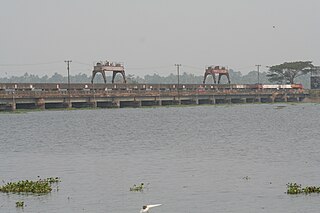
The Thanneermukkom Bund was constructed as a part of the Kuttanad Development Scheme to prevent tidal action and intrusion of salt water into the Kuttanad low-lands across Vembanad Lake between Thannermukkom on west and Vechur on east. Thanneermukkom Bund was constructed in 1974 and is functional since 1976. It is the largest mud regulator in India. This barrier essentially divides the lake into two parts - one with brackish water perennially and the other half with fresh water fed by the rivers draining into the lake.

The West Coast Canal or National Waterway No 3 is a 205-km stretch of this inland navigational route located in Kerala, India and runs from Kollam to Kottapuram and was declared a National Waterway in 1993. In addition to the main stretch, Champakara and Udyogmandal canals are navigable and connect the industrial centers of Kochi to Kochi port Inland Waterways Authority of India (IWAI) under the Ministry of Shipping is coordinating the task for developing, monitoring and administering national waterways. It is the first National Waterway in the country with 24-hour navigation facilities along the entire stretch. It has been extended to Kozhikode as per National Waterways Act, 2016. The National Waterway 3 is passing mainly through the alignment of erstwhile Thiruvananthapuram–Shoranur canal.
Manimala River or Manimalayar is a 92km long river which flows through South and Central Kerala. The river used to be wrongly considered as a tributary of Pamba River before satellite maps became popular, but this was proved incorrect. Manimala does not flow into the Pamba, instead a distributary of the Pamba river flows into the Manimala river at Kallunkal, later branches out again from Manimala at Nedumpuram and flows through Niranam, Thalavady, Edathua, Changankary, Champakulam, Nedumudy, Chennamkary, and finally Kainakary and then empties into the Vembanad lake. This branch again links with Manimala river at Chennankary in a short, but broad connection known as Munnattumukham.

Ilaveezhapoonchira is a tourist destination located in Melukavu village in Kottayam district near Kanjar. Ilaveezha Poonchira is surrounded by three enchanting hillocks - Mankunnu, Kodayathoormala and Thonippara. This makes the place ideal for trekking.
Pallithode is a village in the Alappuzha district, in the state of Kerala, India, on the shores of the Arabian Sea. Pallithode is within the Gram Panchayat of Kuthiathode, Pattanakad Block, of Cherthala Taluk. During the 20th century, more than half of its width was eroded away by the action of river backwaters and the sea. The village is very densely populated and has a wet, maritime tropical climate. It has an important role in the fishing industry.

Kayamkulam Kayal, Kayamkulam Lake or Kayamkulam Estuary is a shallow brackish water lagoon streaching between Panmana and Karthikapally. It has an outlet to the Arabian sea at Kayamkulam barrage. The Kayal used to be connected to the sea most of the time except during dry season when a bar like formation separates it from the sea. Now the bar has been opened up permanently for construction of Kayamkulam Fishing Harbor. Kayamkulam boat race is conducted in Kayamkulam Kayal.

Kollam KSWTD Boat Jetty or Kollam KSWTD Ferry Station is an transport hub in the city of Kollam in Kerala, India, one of 14 ferry stations owned by the Kerala State Water Transport Department.
Waterways have always been an important mode of transport in Kerala. The total length of navigable route in Kerala was 1,900 kilometres and the navigable rivers constitute about 54 per cent of the waterways. The 41 West-flowing rivers together with the backwaters are an integrated part of the inland navigation system in Kerala. In Kerala water transportation through these channels are mainly small distant passenger services, informal country boats, freight transportation to PSU's such as Fertilisers and Chemicals Travancore, Kochi etc.


