Honnavar | |
---|---|
Town | |
Coordinates: 14°16′48″N74°26′38″E / 14.28°N 74.4439°E | |
Country | India |
State | Karnataka |
Region | Kanara |
District | Uttara Kannada |
Taluk | Honnavar |
Established | 1890 [1] |
Government | |
• Type | Municipality |
• Body | Honnavar Town Panchayat |
Elevation | 2 m (7 ft) |
Population (2011) | |
• Total | 19,109 [2] |
Languages | |
• Official | Kannada |
Time zone | UTC+5:30 (IST) |
ISO 3166 code | IN-KA |
Vehicle registration | KA 47 |
Website | honnavaratown |
Honnavar is a town in Uttara Kannada district of Karnataka, India.
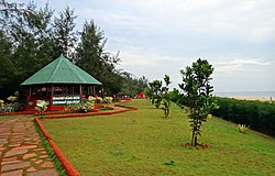
Honnavar is a port town in Coastal Karnataka known for its beautiful landscapes and rich history. The port hosted foreign traders from the Arab world, as well as later from European countries such as Portugal, England and the Netherlands. The 14th century Moroccan traveler Ibn Batutta stopped in the port during his voyage. [3]
During the Portuguese domination a Fortress was built in the 16th century to protect trade in the Indian Ocean. Later in the 18th century the English built warehouses at the port. [4]
The Konkan Railway line passes through Honnavar, and its longest bridge is 2.065 km in length and is in Honnavar, over the Sharavati River. [5]
In October 2013 the Karnataka government announced plans to develop a new port at Honnavar, to be funded by a public–private partnership (PPP) model. [6]
There are proposals for improvements to the Inland Water Transportation system between Honnavar and Gerusoppa along the Sharavati river coast. [7] Also, the Office of Ferries Inspector (Mangalore Circle) that oversees Inland Water Transportation System of the entire coastal belt of Karnataka State is headquartered at Honnavar. [8]
Climate data for Honnavar (1981–2010, extremes 1939–2012) | |||||||||||||
---|---|---|---|---|---|---|---|---|---|---|---|---|---|
Month | Jan | Feb | Mar | Apr | May | Jun | Jul | Aug | Sep | Oct | Nov | Dec | Year |
Record high °C (°F) | 37.7 (99.9) | 39.4 (102.9) | 38.3 (100.9) | 37.5 (99.5) | 38.5 (101.3) | 35.4 (95.7) | 33.7 (92.7) | 32.1 (89.8) | 33.2 (91.8) | 37.1 (98.8) | 37.0 (98.6) | 37.2 (99.0) | 38.5 (101.3) |
Mean daily maximum °C (°F) | 32.8 (91.0) | 32.2 (90.0) | 32.5 (90.5) | 33.1 (91.6) | 33.0 (91.4) | 30.0 (86.0) | 28.7 (83.7) | 28.6 (83.5) | 29.8 (85.6) | 31.5 (88.7) | 33.4 (92.1) | 33.4 (92.1) | 31.6 (88.9) |
Mean daily minimum °C (°F) | 20.3 (68.5) | 20.2 (68.4) | 22.8 (73.0) | 24.9 (76.8) | 25.9 (78.6) | 24.3 (75.7) | 23.8 (74.8) | 23.6 (74.5) | 23.6 (74.5) | 23.5 (74.3) | 22.8 (73.0) | 21.7 (71.1) | 23.1 (73.6) |
Record low °C (°F) | 13.5 (56.3) | 14.2 (57.6) | 17.4 (63.3) | 20.4 (68.7) | 20.5 (68.9) | 20.3 (68.5) | 19.6 (67.3) | 19.4 (66.9) | 18.2 (64.8) | 18.3 (64.9) | 15.6 (60.1) | 14.9 (58.8) | 13.5 (56.3) |
Average rainfall mm (inches) | 0.4 (0.02) | 0.0 (0.0) | 0.9 (0.04) | 9.5 (0.37) | 126.9 (5.00) | 1,009.3 (39.74) | 1,115.6 (43.92) | 842.7 (33.18) | 344.7 (13.57) | 204.4 (8.05) | 48.5 (1.91) | 9.4 (0.37) | 3,712.4 (146.16) |
Average rainy days | 0.1 | 0.0 | 0.1 | 1.0 | 5.3 | 23.0 | 27.8 | 26.3 | 15.1 | 8.5 | 2.2 | 0.7 | 110.0 |
Average relative humidity (%) (at 17:30 IST) | 57 | 60 | 66 | 67 | 70 | 84 | 88 | 88 | 82 | 76 | 62 | 55 | 72 |
Source: India Meteorological Department [9] [10] |
Uttara Kannada is a fifth largest district in the Indian state of Karnataka, It is bordered by the state of Goa and Belagavi districts to the north, Dharwad District and Haveri District to the east, Shivamogga District, and Udupi District to the south, and the Laccadive Sea to the west. Karwar is the district headquarters, Kumta and Sirsi are the major commercial centers in the district. The district's agroclimatic divisions include the coastal plain consisting of Karwar, Ankola, Kumta, Honnavar Bhatkal taluks and Malenadu consisting of Sirsi, Siddapur, Yellapur, Haliyal, Dandeli, Joida, Mundgod taluks.
Shimoga, officially Shivamogga, is a city and the district headquarters of Shimoga district in the Karnataka state of India. The city lies on the banks of the Tunga River. Being the gateway for the hilly region of the Western Ghats, the city is popularly nicknamed the "Gateway of Malnad". The population of Shimoga city is 322,650 as per 2011 census. The city has been selected for the Smart Cities project, standing in the fourth position in the state and 25th in the country as of November 2020.
Ratnagiri is a port city on the Arabian Sea coast in Ratnagiri District in southwestern Maharashtra, India. The district is part of Konkan division of Maharashtra. The city is known for the Hapus or Alphonso mangoes. Ratnagiri is the birthplace of Indian independence activist Lokmanya Tilak. Thibaw, the last king of Burma, alongside his consort Supayalat and two infant daughters were exiled to a two-storied brick mansion in Ratnagiri. The building is now known as Thibaw Palace. This place has many villages like Karla, Rajiwada, Mirkarwada, etc.
Port Blair, officially named as Sri Vijaya Puram, is the capital city of the Andaman and Nicobar Islands, a union territory of India in the Bay of Bengal. It is also the local administrative sub-division (tehsil) of the islands, the headquarters for the district of South Andaman, and the territory's only notified town.
Jog Falls is a waterfall on the Sharavati river located in Siddapur taluk of Uttara Kannada district and its view point in Kargal town of Shimoga district, Karnataka, India. It is the second highest plunge waterfall in India. It is a segmented waterfall which depends on rain and season to become a plunge waterfall. The falls are major attractions for tourists and is ranked 36th in the list of free-falling waterfalls, 490th in the world by list of waterfalls by total height, 128th in the list of single-drop waterfalls in the World by the waterfall database.
Karwar is a seaside city and headquarters of Uttara Kannada district lying at the mouth of Kali river in the Karnataka state of India. Karwar is a popular place known for the INS Kadamba.
Sharavati is a river which originates and flows entirely within the state of Karnataka in India. It is one of the few westward flowing rivers of India and a major part of the river basin lies in the Western Ghats. The famous Jog Falls, located about 25 km from Siddapura, is formed by this river. The river itself and the regions around it are rich in biodiversity and are home to many rare species of flora and fauna.
Chikmagalur previously known as Kiriya-Muguli is a city and the headquarters of Chikmagalur district in the Indian state of Karnataka. Located on the foothills of the Mullayanagiri peak of the Western Ghats, the city attracts tourists from around the world for its pleasant and favourable hill station climate, tropical rainforest and coffee estates. The pristine Baba Budangiri lies to the north of Chikmagalur where it's believed Baba Budan first introduced coffee to India.
Basrur / Basroor is a village in Kundapura taluk in Udupi district of Karnataka. Historically Basrur was also called Barcelor, Barcelore, Barcalor, Basnur, Bares, Abu-Sarur and Barsellor.
Karnataka, a state in South India has a well-developed transport system. Its capital city, Bengaluru is well-connected by air to domestic and international destinations and the Kempegowda International Airport (KIA) in the city is one of the busiest airports in India. It was also the headquarters of the airlines Air Deccan and Kingfisher Airlines. The road transport is also well developed in the state with many National and State highways providing means for fast transportation. The headquarters of the South-Western Railway division of Indian Railways is located at Hubballi and this division governs most of the railway network in the state. Konkan Railway which passes along the coastal region of the state is considered one of the toughest engineering projects being undertaken in India till date. Buses, cars and trains are the means of transport for moving across distant places in Karnataka. For transportation within the city or town limits; motorbikes, cars, autorickshaws and buses are used. With the advent of low-cost airlines, many people are choosing to travel via air as well.
Karnataka's coastline, known as Karavali, stretches 300 km between Mangalore in the Dakshina Kannada district and Karwar in the Uttara Kannada district. This coastline runs along the eastern shore of the Arabian Sea. Karnataka has one major and ten minor ports in this coastal belt. Important rivers in this area, including the Kali, Belekeri, Gangavali, Aghanashini Sharavathi, Sharabi, Kollur, Gangolli, Sitanadi, Gurpur, and Netravati, flow into the Arabian Sea. Sea erosion, the migration of river mouths, and siltation of ports and harbours are some of the common problems facing this region.
Chennai is located at 13.04°N 80.17°E on the southeast coast of India and in the northeast corner of Tamil Nadu. It is located on a flat coastal plain known as the Eastern Coastal Plains. The city has an average elevation of 6 metres (20 ft), its highest point being 60 m (200 ft). Chennai is 2,184 kilometres south of Delhi, 1,337 kilometres southeast of Mumbai, and 1,679 kilometers southwest of Kolkata by road.
Haldipur is a village in Honnavar Taluk in Uttara Kannada District in the southern state of Karnataka, India. It is located in the Honavar taluk of Uttara Kannada district in Karnataka. A sea port is under construction.
The Mirjan Fort is located on the west coast of the Uttara Kannada district in the southern Indian state of Karnataka. The fort known for its architectural elegance was the location of several battles in the past. It is about 0.5 kilometres (0.31 mi) from the National Highway 66 and 21 kilometres (13 mi) from Gokarna, the famous Hindu pilgrimage centre on the west coast of India.
Chandabali is an old town in the Bhadrak district of Odisha on the bank of the River Baitarani.
Basavaraj Durga Island is an island in the Arabian Sea near Honnavar. It is part of Honnavar Taluk in Karnataka State of India.
The Sharavati Bridge is a railway bridge, south of Honnavar, in the state of Karnataka, India, completed in 1994. It carries the Konkan Railway over the Sharavati river.
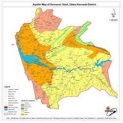
Honnavar Taluk is one of the five coastal taluks in the district of Uttara Kannada in Karnataka, India.
Sagara is a city located in the Indian state of Karnataka. It is also a sub divisional and a taluk headquarters. Located in the Sahyadri Mountain range on the banks of river Varada, it is known for its proximity to Jog Falls and to the historical places of Ikkeri, Keladi and Varadamoola. The river Varada originates near Varada-moola. Sagara subdivision consists of Sagara, Soraba, Hosanagara and Shikaripur taluks.
Hospattan officially known as Hosapatna is a village near the bank of the river Sharavati in Honnavar taluk in the Uttara Kannada district of Karnataka state of India. Once the capital of Nawayath Sultanate and the former settlement of Nawayath community.