Uttara Kannada is a fifth largest district in the Indian state of Karnataka, It is bordered by the state of Goa and Belagavi districts to the north, Dharwad District and Haveri District to the east, Shivamogga District, and Udupi District to the south, and the Laccadive Sea to the west. Karwar is the district headquarters, Kumta and Sirsi are the major commercial centers in the district. The district's agroclimatic divisions include the coastal plain consisting of Karwar, Ankola, Kumta, Honnavar Bhatkal taluks and Malenadu consisting of Sirsi, Siddapur, Yellapur, Haliyal, Dandeli, Joida, Mundgod taluks.
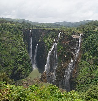
Jog Falls is a waterfall on the Sharavati river located in Siddapur taluk of Uttara Kannada district and its view point in Kargal town of Shimoga district, Karnataka, India. It is the second highest plunge waterfall in India. It is a segmented waterfall which depends on rain and season to become a plunge waterfall. The falls are major attractions for tourists and is ranked 36th in the list of free-falling waterfalls, 490th in the world by list of waterfalls by total height, 128th in the list of single-drop waterfalls in the World by the waterfall database.

Sharavati is a river which originates and flows entirely within the state of Karnataka in India. It is one of the few westward flowing rivers of India and a major part of the river basin lies in the Western Ghats. The famous Jog Falls, located about 25 km from Siddapura, is formed by this river. The river itself and the regions around it are rich in biodiversity and are home to many rare species of flora and fauna.

Palanpur is a city and a headquarters of Banaskantha district in the Indian state of Gujarat. Palanpur is the ancestral home to an industry of Indian diamond merchants.
Dharmasthala is an Indian temple town on the banks of the Nethravathi River in the taluk of Belthangady of the Dakshina Kannada district in Karnataka, India.
Jalgaon district is a district in Maharashtra, India. Its headquarters is the Jalgaon city.
The Saluva dynasty was the second dynasty to rule the Vijayanagara Empire and was created by the Saluvas, who by historical tradition were natives of the Kalyani region of northern Karnataka in modern India. The Gorantla inscription traces their origins to this region from the time of the Western Chalukyas and Kalachuris of Karnataka. The term "Saluva" is known to lexicographers as "hawk" used in hunting. They later spread into the east coast of modern Andhra Pradesh, perhaps by migration or during the Vijayanagara conquests during the 14th century.
Rani is a town and municipality and tehsil of Pali district in the Indian state of Rajasthan. It lies on the banks of Sukri River, a tributary of the Luni River. It is an important railway station on Ahmedabad-Delhi railway line. Some nearby villages are Beejowa,Itendra Medtian,etc.
Parola is a city and a municipal council in Jalgaon district in the Indian state of Maharashtra. It is located on the Hajira (Surat)–Dhule–Kolkata national highway 6. The municipal council was established by the British government before the independence of India. This City is centuries old known for the two main features such as the Shree Balaji Temple and The Parola fort Also known as the native of Rani Laxmibai of Jhansi. City and Fort Build by Jahagirdar Sadashiv Rao Damodar Newalkar the great grandfather in law of Rani Lakshmibai Jhansi.
Honnemaradu is a tourist place situated on the back waters of River Sharavathi in India. Honnemardu derived its name from the Honne tree. However, the literal meaning of Honnemardu is Golden Lake. This is perhaps a reference to the fact that Honnemardu is located on the backwaters of the Sharavathi river.
Talaguppa is a village located in Sagara Taluk in Karnataka State, India. The National Highway No.206 passes through Talaguppa village. The village is 14.37 km from the taluk's center Sagara, 77.68 km from Shivamogga, and 373 km from Bengaluru. It is located at a distance of 14 km from Jog Falls, the highest waterfall in India and Talaguppa is the linking Railway terminus for Jog falls. Areca nut and paddy are the most grown crops.Main reserve station of electricity generated from jog falls and linganamakki dam located here.

Karkala, also known as Karla in Tulu language, is a town and the headquarters of Karkala taluk in the Udupi district of Karnataka, India. Located about 60 km from Mangalore in the Tulu Nadu region of the state, it lies near the foothills of the Western Ghats. Karkala has a number of natural and historical landmarks, and is a major tourist and transit destination due to its strategic location along the way to Hebri, Sringeri, Kalasa, Horanadu, Udupi, Kollur, Subrahmanya and Dharmasthala.

The Mirjan Fort is located on the west coast of the Uttara Kannada district in the southern Indian state of Karnataka. The fort known for its architectural elegance was the location of several battles in the past. It is about 0.5 kilometres (0.31 mi) from the National Highway 66 and 21 kilometres (13 mi) from Gokarna, the famous Hindu pilgrimage centre on the west coast of India.
Bagol is a village in the Desuri tehsil in the Pali district of Rajasthan, India. It was established by Keshu Das and Bheek Singh. It is near Sadri on state highway SH 62 between Ganthi and Magartalav-Kolar, in a valley on the western side of the Aravalli Range. Bagol is accessible by road from Jojawar and Khinwara to Desuri.
Kattinahole is a small village in Hosanagara Taluk, Shimoga district of the Indian state of Karnataka. The local language of Kattinahole is Kannada.
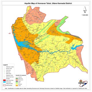
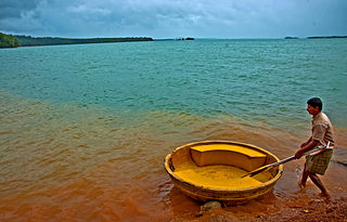
Honnavar Taluk is one of the five coastal taluks in the district of Uttara Kannada in Karnataka, India.
Jagana is a village in the Palanpur taluka of Banaskantha district in northern Gujarat, India. The villages Vasna, Bhagal, Sedrasana are located near to Jagana and it is just 6 km away from the district headquarters, Palanpur.

The Humcha Jain temples or Humcha basadis are a group of temples found in Humcha village of Shimoga district in Karnataka, India. They were constructed in the 7th century CE in the period of the Santara dynasty and are regarded as one of the major Jain centres of Karnataka. The Padmavati Basadi is the most well-known of these temples.

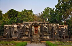
Chaturmukha Basadi is a symmetrical Jain temple located in Gerusoppa in Honnavar Taluk of Uttara Kannada district in the Indian state of Karnataka. The temple is situated near the banks of the Sharavati.

Rani Chennabhairadevi,, was the 16th-century Jain queen of Nagire province under the Vijayanagara Empire. She was officially known as Mahamandaleshwari Rani Chennabhairadevi. She is regarded as being the longest ruling queen in Indian history, from 1552 to 1606, a period of 54 years. She is also known for her wars against the Portuguese in 1559 and 1570, which she won, which helped to start commercial relationships with the Portuguese.