Davanagere

Last updated

Davanagere
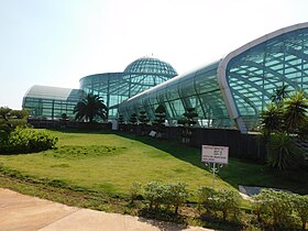
HBPA N 1107 Davanagere Glass House.jpg
'Davanagere glass House'
Nickname: 
India Karnataka location map.svg
Red pog.svg
Davanagere
Davanagere in Karnataka, India
India location map 3.png
Red pog.svg
Davanagere
Davanagere (India)
Coordinates: 14°28′00″N75°55′27″E / 14.4666°N 75.9242°E / 14.4666; 75.9242
CountryFlag of India.svg  India
State Karnataka
District Davanagere
Government
  TypeMunicipal Corporation
  Body Davanagere Mahanagara Palike
  MayorVinayaka B. H.
   MLA (Davanagere North Assembly constituency) S. S. Mallikarjun
   MLA (Davanagere South Assembly constituency) Shamanuru Shivashankarappa
   MP Prabha Mallikarjun
Area
  Total68.63 km2 (26.50 sq mi)
  Rank9th
Population
 (2011-12)
  Total435,125
  Rank9th(Karnataka)
  Density6,300/km2 (16,000/sq mi)
Languages
  Official Kannada
Time zone UTC+5:30 (IST)
PIN
577001-577008
Telephone code08192
Vehicle registration KA-17

Davanagere is a city in the centre of the southern Indian state of Karnataka. It is the seventh largest city in the state, and the administrative headquarters of eponymous Davangere district. [1] Hitherto being a cotton hub and hence popularly known before as the Manchester of Karnataka, the commercial ventures of the city is now dominated by education and agro-processing industries. [2] [3] Davanagere became a separate district in 1997, [4] when it was separated from the erstwhile undivided district of Chitradurga for administration conveniences. Davanagere is known for rich culinary traditions which encompass the diversity of entire Karnataka's dishes due to its geographical position in the state as its centre. Notable among them is its aromatic benne dose. [5] [6]

Contents

Davanagere was selected as one of the hundred Indian cities to be developed as a smart city under the Central government's Smart Cities Mission. It was among the first 20 towns to be developed under the mission by Ministry of Urban Development. [7] According to 2020 human living index, it was selected as the top 9th most livable city with a population under 10 million in India.

Civic administration

Davangere has been at the forefront in municipal administration with the city attaining the status of a municipality as early as 1870. [8] The Imperial Gazetteer of India (1911) says that the receipts and expenditure of the municipality, during the ten years ending 1901, averaged Rs 14,200 and Rs 12,600 respectively. [8] The civic administration of the city was managed by the Nagarasabhe, before it was established as a municipality on 7 August 1951. It now has the status of a City Corporation, which was upgraded on 6 January 2007. It is headed by a Mayor, assisted by Commissioners and council members. The city is divided into 45 wards, and the council members (corporators) are elected by the people of the city.

Geography

Davanagere is the "Heart of Karnataka". Davanagere is surrounded by the Chitradurga, Vijayanagara, Shimoga, Chikmagalur and Haveri districts. Davanagere is at the centre of Karnataka, 14°28' N latitude, 75°59' longitude and 602.5 metres (1,977 ft) above sea level. Davanagere District receives an average annual rainfall of 644 mm (25.4 in). [9]

Davanagere lies in the semi arid region. The district is bounded by Shimoga (Malenadu) Area of Hills, Haveri, Chitradurga, Chikmagalur and Vijayanagara districts. The southern and western parts of the district are irrigated by the waters of the Bhadra reservoir. It has Asia's 2nd largest irrigation tank called Sulekere (shanthi sagara) which is a major water source for farmers in the district.

Demographics

Historical population
YearPop.±%
193123,155    
1941 31,759+37.2%
195156,018+76.4%
196178,124+39.5%
1971121,110+55.0%
1981 196,621+62.3%
1991287,233+46.1%
2001364,523+26.9%
2011435,125+19.4%
Source: [10]
Religions in Davanagere City (2011) [11]
ReligionPercent
Hinduism
73.14%
Islam
24.57%
Jainism
1.04%
Christianity
0.65%
Other or not stated
0.60%

As of the 2011 census, Davanagere city had a population of 435,125. Males constitute 52% of the population, and females 48%. Davanagere has an average literacy rate of 85%, higher than the national average of 74.04%: male literacy is 89% and, female literacy is 81%. [12] In Davanagere, 12% of the population is under 6 years of age.

Languages of Davanagere (2011) [13]

   Kannada (66.37%)
   Urdu (23.82%)
   Telugu (2.81%)
   Marathi (1.96%)
   Tamil (1.17%)
   Konkani (1.04%)
  Others (2.83%)

At the time of the 2011 census, 66.37% of the population spoke Kannada, 23.82% Urdu, 2.81% Telugu, 1.96% Marathi, 1.17% Tamil and 1.04% Konkani as their first language. [13]

Transportation

Davangere is well-connected by road to Bangalore, Chitradurga, Dharwad, Pune, Goa, Mangalore, Mysore and Chennai through NH 48 (previously National Highway 4). Karnataka State Road Transport Corporation, has a divisional office situated in Davanagere City. The city is well-connected to Bengaluru and other cities in the state by KSRTC buses. Many privately operated buses offer overnight services to other places within the state.

Rail

The city's railway station comes under the South Western Railway zone and was constructed during the era of the British Raj and has recently been renovated. The station code is DVG. The railway station is quite conveniently located in the centre of the city. Regular train services are available towards Bengaluru, Hubli and Mysuru.

Air

The nearest domestic airport to Davanagere is Shivamogga Airport (IATA:RQY), which is 100 kilometres (62 mi) from the city and the nearest International airports are Bangalore International Airport and Mangalore International Airport both of which are about 275 km away. The ubiquitous Autorickshaws are the backbone for travelling within the city. The city bus services are operated by both private as well as state owned entreprises.

See also

Related Research Articles

<span class="mw-page-title-main">Shimoga</span> City in Karnataka, India

Shimoga, officially Shivamogga, is a city and the district headquarters of Shimoga district in the central part of the state of Karnataka, India. The city lies on the banks of the Tunga River. Being the gateway for the hilly region of the Western Ghats, the city is popularly nicknamed the "Gateway of Malnad". The population of Shimoga city is 322,650 as per 2011 census. The city has been selected for the Smart Cities project, standing in the fourth position in the state and 25th in the country as of November 2020.

<span class="mw-page-title-main">Chikmagalur district</span> District of Karnataka in India

Chikmagalur, officially Chikkamagaluru is an administrative district in the Malnad subregion of Karnataka, India. Coffee was first cultivated in India in Chikmagalur. The hills of Chikmagalur are parts of the Western Ghats and the source of Tunga and Bhadra rivers. Mullayanagiri, the highest peak in Karnataka is located in the district. The area is well known for the Sringeri Mutt that houses the Dakshina Peeta established by Adi Shankaracharya.

<span class="mw-page-title-main">Haveri district</span> District of Karnataka in India

Haveri is a district in the state of Karnataka, India. As of 2011, it had a population of 1,597,668, out of which 20.78% were urban residents. The district headquarters is Haveri.

<span class="mw-page-title-main">Tungabhadra River</span> River in southern India

The Tungabhadra River starts and flows through the state of Karnataka, India, during most of its course, then through Andhra Pradesh, and ultimately joins the Krishna River near Murvakonda in Andhra Pradesh.

Harihara is a city in Davanagere District in the Indian state of Karnataka. It is the administrative headquarters of the Harihara Taluk. Harihara is famous for Harihareshwara temple.
<span class="mw-page-title-main">Chikmagalur</span> City in Karnataka, India

Chikmagalur is a city and the headquarters of Chikmagalur district in the Indian state of Karnataka. Located on the foothills of the Mullayanagiri peak of the Western Ghats, the city attracts tourists from around the world for its pleasant and favourable hill station climate, tropical rainforest and coffee estates. The pristine Baba Budangiri lies to the north of Chikmagalur where it's believed Baba Budan first introduced coffee to India.
<span class="mw-page-title-main">Hassan district</span> District of Karnataka in India

Hassan is one of the 31 districts of Karnataka, India. The district headquarter is Hassan. It was part of Manjarabad Faujdari a.k.a Patnada Rayada between 1832-81. In 1882, it was reduced into a sub-division under erstwhile Kadur district. But in 1886, the Hassan district was restored to its current form.

<span class="mw-page-title-main">Chitradurga</span> City in Karnataka, India

Chitradurga is a city and the headquarters of Chitradurga district, which is located on the valley of the Vedavati river in the central part of the Indian state of Karnataka. Chitradurga is a place with historical significance which is located to the North West about 200 km from the state capital Bangalore. Chitradurga is a major tourist hub in Karnataka.

<span class="mw-page-title-main">Davanagere district</span> District in Karnataka, India

Davanagere district is an administrative district of Karnataka state in India. It is the centre of Karnataka. The city of Davanagere is the district headquarters. It had a population of 1,643,494 of which 32.31% was urban as of 2011. This district was separated from Chitradurga district in 1997 by the then Chief minister of Karnataka J. H. Patel including Chennagiri and Honali Taluks Shimoga district.

Harapanahalli is a town, taluk and is one of the two sub-divisional headquarter in the Vijayanagara District in the Indian state of Karnataka.

<span class="mw-page-title-main">Mudigere</span> Town in Karnataka, India

Mudigere is a Town and Taluk in Chikmagalur district in the Indian state of Karnataka. It is 30 km from the district headquarters.

Tarikere is a town, a taluk and is one of the two Subdivisional headquarter in the Chikmagalur district of Karnataka state, India. It is popularly known as gateway of Malnad because the Malnad area starts from here. The town's name is derived from the number of water tanks which surround it.

<span class="mw-page-title-main">Ballari district</span> District of Karnataka State, India

Ballari, formerly Bellary, is a major district in Karnataka. It is located at north-eastern part of Karnataka. This district belongs to Kalyana-Karnataka. This district was one of the biggest districts in Karnataka until the Vijayanagara district was carved out of Ballari district in 2021 officially.

<span class="mw-page-title-main">Koppa, India</span> Town in Chikkamagaluru, Karnataka, India

Koppa is a panchayat town in Chikkamagaluru district in the Indian state of Karnataka. It is the headquarters of Koppa sub-district. The name "Koppa" is derived from the Kopada Veerabadra Swamy Temple, a historic site that attracts devotees from the Malnad region.

Hagaribommanahalli is a town and a taluk in Vijayanagara District in the Indian state of Karnataka. It is the administrative headquarters of the Hagaribommanahalli Taluk.

Chigateri is a village in the Harapanahalli Taluk of Vijayanagara District of Karnataka, India.

Shamanur is a village adjacent to Davanagere city and a municipal ward under the municipal corporation of Davanagere city in Davanagere district in the state of Karnataka, India. The predominantly agrarian village, nestled amidst the lush green paddy fields and towering coconut and arecanut orchards, is characterized by its suburban outlook due to its proximity to Davangere city. National Highway 48 separates Shamanur from Davangere city. Shamanur is famous for Sri Anjaneya Swamy Temple.

<span class="mw-page-title-main">Benne dose</span> Type of dosa from Karnataka, India

Davangere benne dose or butter dosa is a type of dosa which traces its origin to the city of Davanagere in Karnataka, India. The term "benne dose" in Kannada means simply "butter dosa." It is prepared by the addition of a generous amount of butter while preparing the normal dosa, and accompanied by coconut chutney. Its batter is very different comprising a mixture of rice, dal, puffed rice, etc., and is prepared on a wood-fired pan. It is similar to masala dosa or set dosa but smaller in size, made out of rice batter and much more butter. It is served with liberal helpings of butter sprinkled on it.

<span class="mw-page-title-main">Outline of Karnataka</span> Overview of and topical guide to Karnataka

The following outline is provided as an overview of and topical guide to Karnataka:

<span class="mw-page-title-main">Belludi Mutt, Harihar</span> Village in Karnataka, India

Belludi Mutt, also known as Baktara Baktiya KuteeraBelludi, is a village in Harihar taluka of Davanagere district in Karnataka, India. Belludi Village is located in Harihar to Shimoga High Way in Harihar Taluka, Davanagere District Karnataka State. Kaginele gurupeeta shakha halumatha mutt is recently built by halumatha kuruba community Swamiji Jagadaguru Shri Niranjanandapuri of Kaginele, Byadagi Taluka, Haveri District, Karnataka, India.

References

  1. "Davangere town Statistics". Archived from the original on 21 December 2012. Retrieved 8 October 2012.
  2. Tejaswi, Marx (21 April 2019). "Caste factor holds key in Karnataka's Manchester". The New Indian Express. Retrieved 13 September 2024.
  3. Shastri, Vittal (25 February 2018). "Battleground karnataka: Davangere Where the Lingayats are keeping everyone guessing". Deccan Chronicle. Retrieved 13 September 2024.
  4. "History | Davanagere District, Government of Karnataka" . Retrieved 27 March 2019.
  5. District Gazetteers Karnataka state
  6. Mujumdar, Neha (22 December 2012). "In search of DAVANGERE BENNE DOSE". The Hindu. ISSN   0971-751X . Retrieved 26 July 2022.
  7. "Davanagere, Belagavi Among 1st Smart Cities". The New Indian Express-28-Jan-2016. Archived from the original on 30 January 2016. Retrieved 10 February 2016.
  8. 1 2 "Imperial Gazetteer2 of India, Volume 11, page 204 -- Imperial Gazetteer of India -- Digital South Asia Library". dsal.uchicago.edu.
  9. "NIC.in" . Retrieved 28 April 2024.
  10. Census Tables censusindia.gov.in [ dead link ]
  11. "Table C-01 Population By Religion - Karnataka". census.gov.in. Registrar General and Census Commissioner of India.
  12. "Davanagere City Census 2011 data". Census 2011. Retrieved 14 September 2018.
  13. 1 2 "Table C-16 Population by Mother Tongue (Urban): Karnataka". censusindia.gov.in. Registrar General and Census Commissioner of India.