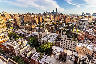
Greenwich Village, or simply the Village, is a neighborhood on the west side of Lower Manhattan in New York City, bounded by 14th Street to the north, Broadway to the east, Houston Street to the south, and the Hudson River to the west. Greenwich Village also contains several subsections, including the West Village west of Seventh Avenue and the Meatpacking District in the northwest corner of Greenwich Village.

A ghost town, deserted city, extinct town, or abandoned city is an abandoned settlement, usually one that contains substantial visible remaining buildings and infrastructure such as roads. A town often becomes a ghost town because the economic activity that supported it has failed or ended for any reason. The town may have also declined because of natural or human-caused disasters such as floods, prolonged droughts, extreme heat or extreme cold, government actions, uncontrolled lawlessness, war, pollution, or nuclear and radiation-related accidents and incidents. The term can sometimes refer to cities, towns, and neighborhoods that, though still populated, are significantly less so than in past years; for example, those affected by high levels of unemployment and dereliction.

Westchester County is a county located in the southeastern portion of the U.S. state of New York, bordering the Long Island Sound to its east and the Hudson River on its west. The county is the seventh most populous county in the State of New York and the most populous north of New York City. According to the 2020 United States Census, the county had a population of 1,004,456, its highest decennial count ever and an increase of 55,344 (5.8%) from the 949,113 counted in 2010. Westchester covers an area of 450 square miles (1,200 km2), consisting of six cities, 19 towns, and 23 villages. Established in 1683, Westchester was named after the city of Chester, England. The county seat is the city of White Plains, while the most populous municipality in the county is the city of Yonkers, with 211,569 residents per the 2020 census. The county is part of the Hudson Valley region of the state.

A town is a type of a human settlement. Towns are generally larger than villages and smaller than cities, though the criteria to distinguish between them vary considerably in different parts of the world.

A gay village, also known as a gayborhood, is a geographical area with generally recognized boundaries that is inhabited or frequented by many lesbian, gay, bisexual, transgender, and queer (LGBT) people. Gay villages often contain a number of gay-oriented establishments, such as gay bars and pubs, nightclubs, bathhouses, restaurants, boutiques, and bookstores.

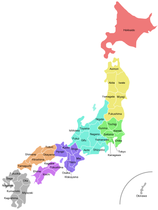
Japan is divided into 47 prefectures, which rank immediately below the national government and form the country's first level of jurisdiction and administrative division. They include 43 prefectures proper, two urban prefectures, one regional prefecture and one metropolis. In 1868, the Meiji Fuhanken sanchisei administration created the first prefectures to replace the urban and rural administrators in the parts of the country previously controlled directly by the shogunate and a few territories of rebels/shogunate loyalists who had not submitted to the new government such as Aizu/Wakamatsu. In 1871, all remaining feudal domains (han) were also transformed into prefectures, so that prefectures subdivided the whole country. In several waves of territorial consolidation, today's 47 prefectures were formed by the turn of the century. In many instances, these are contiguous with the ancient ritsuryō provinces of Japan.
A census-designated place (CDP) is a concentration of population defined by the United States Census Bureau for statistical purposes only.

A hamlet is a human settlement that is smaller than a town or village. This is often simply an informal description of a smaller settlement or possibly a subdivision or satellite entity to a larger settlement. Sometimes a hamlet is defined for official or administrative purposes.

The administrative divisions of New York are the various units of government that provide local services in the American state of New York. The state is divided into boroughs, counties, cities, towns, and villages. They are municipal corporations, chartered (created) by the New York State Legislature, as under the New York State Constitution the only body that can create governmental units is the state. All of them have their own governments, sometimes with no paid employees, that provide local services. Centers of population that are not incorporated and have no government or local services are designated hamlets. Whether a municipality is defined as a borough, city, town, or village is determined not by population or land area, but rather on the form of government selected by the residents and approved by the New York State Legislature. Each type of local government is granted specific home rule powers by the New York State Constitution. There are still occasional changes as a village becomes a city, or a village dissolves, each of which requires legislative action. New York also has various corporate entities that provide local services and have their own administrative structures (governments), such as school and fire districts. These are not found in all counties.
Gram Panchayat is a basic governing institution in Indian villages. It is a political institution, acting as the cabinet of a village or group of villages. The Gram Sabha works as the general body of the Gram Panchayat. The members of the gram panchayat are elected directly by the people. The gram panchayat is headed by an elected President and Vice President, assisted by a Secretary who serves as the administrative head of the panchayat. The president of a gram panchayat is known as a "Pradhan" or "Sarpanch" in Northern India. There are about 250,000 gram panchayats present in India.
Nayakas of Chitradurga (1588–1779) were an Indian dynasty that ruled parts of eastern Karnataka during the post-Vijayanagara period, centered at Chitradurga. During the rule of the Hoysala Empire and the Vijayanagara Empire, they served as a feudatory chiefdom. Later, after the fall of the Vijayanagara Empire, they ruled at times as an independent chiefdom and at other times as a vassal of the Mysore Kingdom, Mughal Empire and Maratha Empire. Their territories merged into the Kingdom of Mysore under British rule.
Santaji Ghorpade (1660–1696) was a Maratha general and held the esteemed position of the 7th Senapati within the Maratha Empire during the reign of Chattrapati Rajaram I. He is widely regarded as one of the foremost experts in Guerrilla warfare. Santaji Ghorpade, in collaboration with Dhanaji Jadhav, conducted a series of successful campaigns against the Mughals from 1689 to 1696. His strategic acumen was demonstrated through the adept utilization of tactics such as guerrilla warfare, ambushes, and swift mobility, ultimately resulting in effective defeats of the Mughal Army. In recognition of his valor, Rajaram bestowed upon him the title of Mamlakat-Madar in 1690.

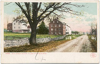
In the United States, the meaning of village varies by geographic area and legal jurisdiction. In formal usage, a "village" is a type of administrative division at the local government level. Since the Tenth Amendment to the United States Constitution prohibits the federal government from legislating on local government, the states are free to have political subdivisions called "villages" or not to and to define the word in many ways. Typically, a village is a type of municipality, although it can also be a special district or an unincorporated area. It may or may not be recognized for governmental purposes.

The Folklore Museum at Mysore, India, is a museum which exhibits folk art and crafts from all over the state of Karnataka

A village development committee in Nepal was the lower administrative part of its Ministry of Federal Affairs and Local Development. Each district had several VDCs, similar to municipalities but with greater public-government interaction and administration. There were 3,157 village development committees in Nepal. Each village development committee was further divided into several wards depending on the population of the district, the average being nine wards.

Village People is an American disco group known for its on-stage costumes and suggestive lyrics in their music. The group was originally formed by French producers Jacques Morali, Henri Belolo and lead singer Victor Willis following the release of the debut album Village People, which targeted disco's large gay audience. The group's name refers to Manhattan's Greenwich Village, with its reputation as a gay village. The characters were a symbolic group of American masculinity and macho gay-fantasy personas. To date, Willis is the only original member still remaining with the group.
P.R. Thippeswamy was an artist and folklorist of Karnataka. He was popularly known as PRT. He was instrumental in establishment of the "Folklore Museum" in Mysore in 1968. He was also the first curator of the museum. The folklore museum contains Representative collection of arts and crafts from all over Karnataka. P.R.Thippeswamy brought material from all over Karnataka to increase the collection. One of the displays in the museum is the "Ink" prepared locally by the great grandfather of the late P.R.Thippeswamy at Dodderi village of Chitradurga District 200 years ago.
The siege of Basavapatan was a military engagement between the Mughal Army and the Maratha troops led by Santaji Ghorpade, the Marathas were defeated and Basavapatan was relieved.
State Highway 25 also known as Hosapete-Shivamogga Road or SH-25, is a state highway connecting Hosapete of Vijayanagar district and Shivamogga City in Shivamogga district, in the South Indian state of Karnataka. It has a total length of 194.46 kilometres (120.83 mi).
The Battle of Dodderi was a three-day battle of the Deccan wars between the Maratha forces led by Santaji Ghorpad and the Mughal army, with support from the Nayak of Chitaldurg. Santaji's strategic attacks disrupted the Mughal advance, leading to the death of Mughal commander Qasim Khan. The Mughals retreated to the fort of Dodderi, where they faced starvation and hard conditions due to a tight Maratha blockade. Mughal commander Khanazad Khan surrendered and agreed to pay a ransom of 100,000 rupees. The battle is considered a decisive defeat for the Mughal Empire.


